
A ghost town, deserted city, extinct town, or abandoned city is an abandoned settlement, usually one that contains substantial visible remaining buildings and infrastructure such as roads. A town often becomes a ghost town because the economic activity that supported it has failed or ended for any reason. The town may have also declined because of natural or human-caused disasters such as floods, prolonged droughts, extreme heat or extreme cold, government actions, uncontrolled lawlessness, war, pollution, or nuclear and radiation-related accidents and incidents. The term can sometimes refer to cities, towns, and neighborhoods that, though still populated, are significantly less so than in past years; for example, those affected by high levels of unemployment and dereliction.
Goshen was a pioneer town in western Whatcom County.
Nanoose Bay is a community on the east coast of southern Vancouver Island, British Columbia, Canada. The location off BC Highway 19 is by road about 26 kilometres (16 mi) north of Nanaimo, and 16 kilometres (10 mi) south of Parksville.
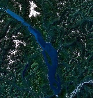
Harrison Lake is the largest lake in the southern Coast Mountains of Canada, being about 250 square kilometres (95 mi²) in area. It is about 60 km (37 mi) in length and at its widest almost 9 km (5.6 mi) across. Its southern end, at the resort community of Harrison Hot Springs, is c. 95 km east of downtown Vancouver. East of the lake are the Lillooet Ranges while to the west are the Douglas Ranges. The lake is the last of a series of large north-south glacial valleys tributary to the Fraser along its north bank east of Vancouver, British Columbia. The others to the west are the Chehalis, Stave, Alouette, Pitt, and Coquitlam Rivers. Harrison Lake is a natural lake, not man-made. The lake is supplied primarily from the Lillooet River, which flows into the lake at the northernmost point.
Emory Creek Provincial Park is a provincial park in British Columbia, Canada, located on the west side of the Fraser River just south of the town of Yale. It commemorates the location of a large boomtown, variously known as Emory, Emory Bar or Emory City, that first rose during the Fraser Canyon Gold Rush but became a major construction town during the building of the Canadian Pacific Railway in the 1880s.
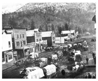
Emory Creek in 1858 was a tent and shack camp, established by miners in search of gold. When it became evident that the gold was not available in the amounts estimated, the miners started moving north on the Fraser River. A few Chinese remained in the area. The area came into the hands of a man named Walker, who felt Emory Creek would become the head of riverboat navigation on the Fraser. Eventually, he sold the land to the Oppenheimer Brothers in early 1879. In the fall of 1879, Emory was chosen by the C.P.R. as the western terminus. In a short time it became Emory Creek. The town consisted of thirteen streets with its own newspaper, various shops, a brewery, nine saloons and a sawmill. When Yale was made the terminus, Emory was all but abandoned by 1885, with the completion of the railway. Today, it is an easily accessible treed campground with paved roads and flush outhouses.
Francis Xavier Richter Jr. was a Canadian politician, who served as a Member of the Legislative Assembly and Minister of Agriculture, Minister of Commercial Transport, and Minister of Mines and Petroleum Resources in the Social Credit government of W.A.C. Bennett in the province of British Columbia. He represented the riding of Similkameen from 1953 to 1966 and its successor riding Boundary-Similkameen from 1966 to 1975.
The Similkameen Gold Rush, also known as the Blackfoot Gold Rush, was a minor gold rush in the Similkameen Country of the Southern Interior of British Columbia, Canada, in 1860. The Similkameen Rush was one of a flurry of small rushes peripheral to the Fraser Canyon Gold Rush, which had drawn tens of thousands of prospectors to the new colony in 1858-1859, among the others being Rock Creek Gold Rush and Big Bend.
Cascade City or Cascade was a Canadian Pacific Railway construction era boom town in the Boundary Country of the West Kootenay region of British Columbia, Canada. Because of its location near the Canada–United States border, it was also called the "Gateway to the Boundary Country".
Fort Rupert is the site of a former Hudson's Bay Company (HBC) fort on the east coast near the northern tip of Vancouver Island, British Columbia. The unincorporated community on Beaver Harbour is about 11 kilometres (7 mi) by road southeast of Port Hardy.

Blubber Bay is an unincorporated settlement on the northern end of Texada Island at the bay of the same name in the northern Gulf of Georgia on the South Coast of British Columbia, Canada. The ferry from Powell River docks at Blubber Bay, which sits beside quarry offices, pits and workings which stretch up the hill. The north rim of the bay has the disused workings of BC Cement Company with dock, work area, and various pits stretching out to the headland. There is a museum and archives and a small store located above the ferry landing.
Derby is a locality on the lower Fraser River in northwestern Langley. The site of the original Fort Langley, established in 1827 by the Hudson's Bay Company, and was the first post established in Coast Salish territory. The Fort was later moved 4 km to its present location in 1839. In 1858, when the Royal Engineers arrived, they built barracks in Derby. All signs of the town and fort have since disappeared, with the locality now only an intersection in the middle of farmland. Its church, the Church of St. John the Divine, was moved across the river to what is now Maple Ridge, where it remains today. The only surviving trace of Derby on the map is the Derby Reach of the Fraser, which describes the northward arc of the Fraser south of Haney and the associated Derby Reach Regional Park.
Victoria most often refers to:
Comaplix was a former mining town on the Incomappleux River in the Upper Arrow Lake area of the West Kootenay region of British Columbia. The name of the town and an adjacent mountain and creek derived from the river. Cleared in 1896, the town was surveyed and a sawmill established the next year. The suspicious 1915 fire, which levelled the buildings, largely ended the flourishing hamlet. The site, north of Beaton, on the northeast side of the lake's Beaton Arm, comprised merely concrete foundations when the Keenleyside Dam reservoir submerged the area in 1968. The small overgrown cemetery above the townsite is all that remains.

Beaton is at the head of the Beaton Arm of Upper Arrow Lake in the West Kootenay region of southeastern British Columbia. The locality is sometimes confused with nearby Evansport.
Belcher Camp is a ghost town located in Ferry County, Washington, United States. The town is located on upper Lambert Creek, nearly ten miles northeast of Republic. The town was founded around 1897 when Iron ore was discovered in the vicinity. The Belcher Mountain Mining Company began operations in the area. By 1906 the town had a population of about 72. The town contained a post office, large bunkhouse for single miners, a general store, five or six houses and a railroad. There was even a Belcher Mountain Railroad line. Eventually the mine folded and the town disappeared.
Leeblain is a ghost town in the Canadian province of Ontario, located on the north shore of Gunflint Lake in the Thunder Bay District, partly within La Verendrye Provincial Park and next to the Boundary Waters Canoe Area Wilderness in the Boundary Waters between Canada and the United States.
