Related Research Articles

Israeli settlements, also called Israeli colonies, are the civilian communities built by Israel throughout the Israeli-occupied territories. They are populated by Israeli citizens, almost exclusively of Jewish identity or ethnicity, and were built on lands occupied by Israel since the Six-Day War in 1967. The international community considers Israeli settlements to be illegal under international law, but Israel disputes this. The expansion of settlements often involves the confiscation of Palestinian land and resources, leading to displacement of Palestinian communities and creating a source of tension and conflict. Settlements are often protected by the Israeli military and are frequently flashpoints for violence against Palestinians. Further, the presence of settlements and Jewish-only bypass roads creates a fragmented Palestinian territory, seriously hindering economic development and freedom of movement for Palestinians.

Jerusalem is a city in the Southern Levant, on a plateau in the Judaean Mountains between the Mediterranean and the Dead Sea. It is one of the oldest cities in the world, and is considered holy to the three major Abrahamic religions—Judaism, Christianity, and Islam. Both the State of Israel and Palestine claim Jerusalem as their capital. Israel maintains its primary governmental institutions there, and Palestine ultimately foresees it as its seat of power. Neither claim is widely recognized internationally.

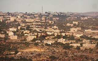
The West Bank, so called due to its relation to the Jordan River, is the larger of the two Palestinian territories. A landlocked territory near the coast of the Mediterranean Sea in the Levant region of West Asia, it is bordered by Jordan and the Dead Sea to the east and by Israel to the south, west, and north. The territory has been under Israeli occupation since 1967.

The Israeli–Palestinian conflict is an ongoing military and political conflict about land and self-determination within the territory of the former Mandatory Palestine. Key aspects of the conflict include the Israeli occupation of the West Bank and Gaza Strip, the status of Jerusalem, Israeli settlements, borders, security, water rights, the permit regime, Palestinian freedom of movement, and the Palestinian right of return.

The Palestinian territories are the two regions of the former British Mandate for Palestine that have been occupied by Israel since the Six-Day War of 1967, namely the West Bank and the Gaza Strip. The International Court of Justice (ICJ) has referred to the West Bank, including East Jerusalem, as "the Occupied Palestinian Territory", and this term was used as the legal definition by the ICJ in its advisory opinion of July 2004. The term occupied Palestinian territory was used by the United Nations and other international organizations between October 1999 and December 2012 to refer to areas controlled by the Palestinian National Authority, but from 2012, when Palestine was admitted as one of its non-member observer states, the United Nations started using exclusively the name State of Palestine. The European Union (EU) also uses the term "occupied Palestinian territory". The government of Israel and its supporters use the label "disputed territories" instead.
Arab–Israeli peace projects are projects to promote peace and understanding between the Arab League and Israel in different spheres. These are part of a broader attempt at a peace process between Palestinians and Israelis. Sponsors of such projects can be found both in Israel and Palestine.

Beitar Illit is a Haredi Jewish-Israeli settlement organized as a city council in the Gush Etzion settlement bloc, ten kilometres (6 mi) southwest of Jerusalem in the West Bank. Beitar Illit is one of Israel's largest and most rapidly growing settlements, and in 2022 had a population of 64,016.
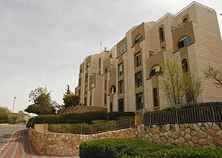
Ma'ale Adumim is an urban Israeli settlement organized as a city council in the West Bank, seven kilometers east of Jerusalem. Ma'ale Adumim achieved city status in 1991. In 2015, its population was 38,046. It is located along Highway 1, which connects it to Jerusalem and the Tel Aviv Metropolitan Area. Israeli settlements in the West Bank are illegal under international law.

The Israeli West Bank barrier, comprising the West Bank Wall and the West Bank fence, is a separation barrier built by Israel along the Green Line and inside parts of the West Bank. Israel describes the wall as a necessary security barrier against Palestinian political violence; whereas Palestinians describe it as an element of racial segregation and a representation of Israeli apartheid, who often call it "Wall of Apartheid". At a total length of 708 kilometres (440 mi) upon completion, the route traced by the barrier is more than double the length of the Green Line, with 15% of its length running along the Green Line or inside Israel, and the remaining 85% running as much as 18 kilometres (11 mi) inside the West Bank, effectively isolating about 9% of the land and approximately 25,000 Palestinians from the rest of the Palestinian territory.

A separation barrier or separation wall is a barrier, wall or fence, constructed to limit the movement of people across a certain line or border, or to separate peoples or cultures. A separation barrier that runs along an internationally recognized border is known as a border barrier.

The Gaza–Israel barrier is a border barrier located on the Israeli side of the Gaza–Israel border. Before the 2023-24 Israel-Hamas war, the Erez Crossing, in the north of the Gaza Strip, used to be the only crossing point for people and goods coming from Israel into the Gaza Strip, with a second crossing point, the Kerem Shalom border crossing, used exclusively for goods coming from Egypt, as Israel didn't allow goods to go directly from Egypt into Gaza through the Egypt–Gaza border, except for the Salah Al Din Gate, opened in 2018.

Isratin or Isratine, also known as the bi-national state, is a proposed unitary, federal or confederate Israeli-Palestinian state encompassing the present territory of Israel, the West Bank and the Gaza Strip. Depending on various points of view, such a scenario is presented as a desirable one-state solution to resolving the Israeli–Palestinian conflict, or as a calamity in which Israel would ostensibly lose its character as a Jewish state and the Palestinians would fail to achieve their national independence within a two-state solution. Increasingly, Isratin is being discussed not as an intentional political solution – desired or undesired – but as the probable, inevitable outcome of the continuous growth of the Jewish settlements in the West Bank and the seemingly irrevocable entrenchment of the Israeli occupation there since 1967.

Har Gilo is an Israeli settlement in the West Bank, organized as a community settlement, located about 2 kilometers west of the Palestinian city of Bethlehem and 5 kilometers south of Jerusalem, in the northern Judean hills.
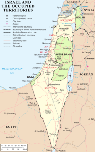
Israel has occupied the Palestinian territories and the Golan Heights since the Six-Day War of 1967. It previously occupied the Sinai Peninsula and southern Lebanon as well. Prior to Israel's victory in the Six-Day War, occupation of the Palestinian territories was split between Egypt and Jordan, with the former having occupied the Gaza Strip and the latter having annexed the West Bank; the Sinai Peninsula and the Golan Heights were under the sovereignty of Egypt and Syria, respectively. The first conjoined usage of the terms "occupied" and "territories" with regard to Israel was in United Nations Security Council Resolution 242, which was drafted in the aftermath of the Six-Day War and called for: "the establishment of a just and lasting peace in the Middle East" to be achieved by "the application of both the following principles: ... Withdrawal of Israeli armed forces from territories occupied in the recent conflict ... Termination of all claims or states of belligerency and respect for and acknowledgment of the sovereignty, territorial integrity and political independence of every State in the area and their right to live in peace within secure and recognized boundaries free from threats or acts of force."
Bil'in is a Palestinian village located in the Ramallah and al-Bireh Governorate, 12 kilometres (7.5 mi) west of the city of Ramallah in the central West Bank. According to the Palestinian Central Bureau of Statistics, Bil'in had a population of 2,137 in 2017. In the 2000s, it was known for its regular protests against Israeli occupation.

Demographic features of the population of the area commonly described as Palestinian territories includes information on ethnicity, education level, health of the populace, economic status, religious affiliations and other aspects of that population.
Karmei Tzur, or Carmei Tzur is an Israeli settlement organized as a community settlement in the West Bank located north of Hebron in the Judean hills between the Palestinian towns of Beit Ummar and Halhul. The National Religious community falls under the jurisdiction of Gush Etzion Regional Council. Under the terms of the Oslo Accords of 1993 between Israel and the Palestine Liberation Organization, Karmei Tzur was designated Area "C" under full Israeli civil and security control. In 2022 it had a population of 980.

Psagot is an Israeli settlement in the West Bank, located on Tawil hill, adjacent to the Palestinian cities of Ramallah and al-Bireh. Established in 1981, it is organised as a community settlement and falls under the jurisdiction of Binyamin Regional Council, with the council's headquarters located there. In 2022 it had a population of 2,086.
Hafrada is the policy of the government of Israel to separate the Israeli population from the Palestinian population in the occupied Palestinian territories, in both the West Bank and the Gaza Strip.
The Alternative Information Center (AIC) is a joint Palestinian-Israeli non-governmental organization (NGO) which "engages in dissemination of information, political advocacy, grassroots activism and critical analysis of the Palestinian and Israeli societies as well as the Israeli–Palestinian conflict". It was established in February 1984 by Israeli activists from the Revolutionary Communist League (previously Matzpen-Jerusalem) and Palestinian leftwing activists from the West Bank.
References
- 1 2 Wilson, Mary (2007-05-30). "Backs Against the Wall". Philadelphia City Paper. Paul Curci. Archived from the original on 2013-02-21. Retrieved 2008-01-13.
- 1 2 Fraser, Genevieve Cora (2006-11-20). "Israel's Iron Will Inspired "The Iron Wall"". Arabic Media Internet Network. Archived from the original on 2007-08-15. Retrieved 2008-01-13.