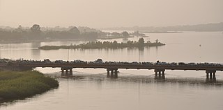
The Niger River is the main river of West Africa, extending about 4,180 kilometres. Its drainage basin is 2,117,700 km2 (817,600 sq mi) in area. Its source is in the Guinea Highlands in south-eastern Guinea near the Sierra Leone border. It runs in a crescent shape through Mali, Niger, on the border with Benin and then through Nigeria, discharging through a massive delta, known as the Niger Delta, into the Gulf of Guinea in the Atlantic Ocean. The Niger is the third-longest river in Africa, exceeded by the Nile and the Congo River. Its main tributary is the Benue River.

Irrigation is the practice of applying controlled amounts of water to land to help grow crops, landscape plants, and lawns. Irrigation has been a key aspect of agriculture for over 5,000 years and has been developed by many cultures around the world. Irrigation helps to grow crops, maintain landscapes, and revegetate disturbed soils in dry areas and during times of below-average rainfall. In addition to these uses, irrigation is also employed to protect crops from frost, suppress weed growth in grain fields, and prevent soil consolidation. It is also used to cool livestock, reduce dust, dispose of sewage, and support mining operations. Drainage, which involves the removal of surface and sub-surface water from a given location, is often studied in conjunction with irrigation.
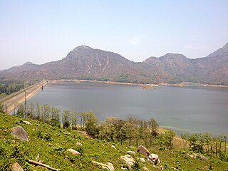
Pothundi Dam is an irrigation dam near Pothundi village in the Palakkad district of Kerala state, India. Constructed in the 19th century, it is considered one of the oldest dams in India. It provides irrigation to an area of 5,470 hectares in the Palakkad district and drinking water supply to the Nemmara, Ayalur, Melarcode Panchayat. An unusual feature of the earth dam is the core wall, which is built with a mixture of jaggery and quick lime.

Tajikistan is a highly agrarian country, with its rural population at more than 70% and agriculture accounting for 60% of employment and around 20% of GDP in 2020. As is typical of economies dependent on agriculture, Tajikistan has a low income per capita: Soviet Tajikistan was the poorest republic with a staggering 45% of its population in the lowest income “septile”. In 2006 Tajikistan still had the lowest income per capita among the Commonwealth of Independent States (CIS) countries: $1,410 compared with nearly $12,000 for Russia. The low income and the high agrarian profile justify and drive the efforts for agricultural reform since 1991 in the hope of improving the population's well-being.
Mexico, a classified arid and semi-arid country, has a total land area of 2 million square kilometres, 23% of which is equipped for irrigated agriculture. The agricultural sector plays an important role in the economic development of the country accounting for 8.4 of agricultural gross domestic product (GDP) and employing 23% of the economically active population. Irrigated agriculture contributes about 50% of the total value of agricultural production and accounts for about 70% of agriculture exports. Mexico's government initiated a number of structural reforms in the water sector aimed to introduce modern water management and irrigation.

Agriculture employs the majority of Madagascar's population. Mainly involving smallholders, agriculture has seen different levels of state organisation, shifting from state control to a liberalized sector.
Irrigation in Brazil has been developed through the use of different models. Public involvement in irrigation is relatively new while private investment has traditionally been responsible for irrigation development. Private irrigation predominates in the populated South, Southeast, and Center-West regions with most of the country’s agricultural and industrial development. In the Northeast region, investments made by the public sector seek to stimulate regional development in an area prone to droughts and with serious social problems. These different approaches have resulted in diverse outcomes. Of the 120 million hectares (ha) that are potentially available for agriculture, only about 3.5 million ha are under irrigation, although estimates show that 29 million ha are suitable for this practice.
Agricultural land is typically land devoted to agriculture, the systematic and controlled use of other forms of life—particularly the rearing of livestock and production of crops—to produce food for humans. It is generally synonymous with both farmland or cropland, as well as pasture or rangeland.
Irrigation in Colombia has been an integral part of Colombia's agricultural and rural development in the 20th Century. Public investment in irrigation has been especially prominent in the first half of the Century. During the second half, largely driven by fiscal shortages and a common inability to raise sufficient revenues from collection of water charges, the Colombian government adopted a program to devolve irrigation management responsibility to water users associations. Irrigation management transfer has occurred only partially in Colombia, as the government has maintained strong managerial tasks in certain irrigation districts.
Irrigation in the Dominican Republic (DR) has been an integral part of DR agricultural and economic development in the 20th century. Public investment in irrigation has been the main driver for irrigation infrastructural development in the country. Irrigation Management Transfer to Water Users Associations (WUAs), formally started in the mid-1980s, is still an ongoing process showing positive signs with irrigation systems in 127,749 ha, being managed by 41,329 users. However, the transfer process and the performance of WUAs are still far from ideal. While WUAs show a significant increase in cost recovery, especially when compared to low values in areas under state management, a high subsidy from the government still contributes to cover operation and maintenance costs in their systems.

The environmental impact of irrigation relates to the changes in quantity and quality of soil and water as a result of irrigation and the subsequent effects on natural and social conditions in river basins and downstream of an irrigation scheme. The effects stem from the altered hydrological conditions caused by the installation and operation of the irrigation scheme.
This page shows statistical data on irrigation of agricultural lands worldwide.
Irrigation is the artificial abstraction of water from a source followed by the distribution of it at scheme level aiming at application at field level to enhance crop production when rainfall is scarce.
Costa Rica is divided into three major drainage basins encompassing 34 watersheds with numerous rivers and tributaries, one major lake used for hydroelectric generation, and two major aquifers that serve to store 90% of the municipal, industrial, and agricultural water supply needs of Costa Rica. Agriculture is the largest water user demanding around 53% of total supplies while the sector contributes 6.5% to the Costa Rica GDP. About a fifth of land under cultivation is being irrigated by surface water. Hydroelectric power generation makes up a significant portion of electricity usage in Costa Rica and much of this comes from the Arenal dam.
Water resources management in Nicaragua is carried out by the National water utility and regulated by the Nicaraguan Institute of water. Nicaragua has ample water supplies in rivers, groundwater, lagoons, and significant rainfall. Distribution of rainfall is uneven though with more rain falling on an annual basis in the Caribbean lowlands and much lower amounts falling in the inland areas. Significant water resources management challenges include contaminated surface water from untreated domestic and industrial wastewater, and poor overall management of the available water resources.
Water resources management in El Salvador is characterized by difficulties in addressing severe water pollution throughout much of the country's surface waters due to untreated discharges of agricultural, domestic and industrial run off. The river that drains the capital city of San Salvador is considered to be polluted beyond the capability of most treatment procedures.
Guatemala faces substantial resource and institutional challenges in successfully managing its national water resources. Deforestation is increasing as the global demand for timber exerts pressure on the forests of Guatemala. Soil erosion, runoff, and sedimentation of surface water is a result of deforestation from development of urban centers, agriculture needs, and conflicting land and water use planning. Sectors within industry are also growing and the prevalence of untreated effluents entering waterways and aquifers has grown alongside.
Water resources management in Belize is carried out by the Water and Sewerage Authority (WASA) in most cases. One of the primary challenges the country is facing with regard to water resources management, however, is the lack of coordinated and comprehensive policies and institutions. Furthermore, there are various areas of water management that are not well addressed at all such as groundwater data and provision of supply. Data on irrigation and drainage is not adequately available either. Demand on water resources is growing as the population increases, new economic opportunities are created, and the agriculture sector expands. This increased demand is placing new threats on the quality and quantity of freshwater resources. Other constant challenge for management entities are the constant threat of floods from tropical storms and hurricanes. The Belize National Emergency Management Organization (NEMO) is charged with flood management as they occur but it is unclear what institution has responsibility for stormwater infrastructures.

The Ha Chhu is a river in west-central Bhutan, it is a tributary of the Raidak River.

Irrigation in India includes a network of major and minor canals from Indian rivers, groundwater well based systems, tanks, and other rainwater harvesting projects for agricultural activities. Of these groundwater system is the largest. In 2013–14, only about 36.7% of total agricultural land in India was reliably irrigated, and remaining 2/3 cultivated land in India is dependent on monsoons. 65% of the irrigation in India is from groundwater. Currently about 51% of the agricultural area cultivating food grains is covered by irrigation. The rest of the area is dependent on rainfall which is most of the times unreliable and unpredictable.
In 1977 the Board of Governors of the World Bank approved Bura Irrigation and Settlement Project (BISP) in Kenya. The project area is situated just South of the Equator in the Lower Tana Basin. It lies on the west bank of the Tana River and falls within the administrative area of Tana River County. The project was an ambitious attempt of the government of Kenya, the World Bank and a few other donors to develop a remote area, create employment for thousands of people with a reasonable income and earn foreign exchange. Bura project would develop about 6,700 net irrigated ha over a 5 1⁄2 year period and settle on smallholdings about 5,150 landless poor families selected from all parts of Kenya. Physical and social infrastructure would be provided to support the settler and satellite population, expected to reach a total of 65,000 persons by 1985. The total cost of the project was estimated at 92 million dollars in 1977 prices. Actual construction started in 1978. During implementation the costs exploded from $17,500/= per family to $55,000/=, a new record for the World Bank. The largest cost increase was for the irrigation network (615%). The donors were not willing and the government was not able to raise the additional funds and subsequently the size of the project was scaled down from 6,700 ha to 3,900 and later to 2,500 ha, although the irrigation structures were completed for 6,700 ha. In this period 2,100 landless households from all over Kenya were settled in the scheme. They were allocated two plots of 0.625 ha and a garden of 0.05 ha. Each year they were to grow 1.25 ha cotton and 0.625 maize intercropped with cowpeas. Soon it was evident that the project would fail to achieve its objectives. Job creation was only 40% of the target, the economic rate of return was negative and the annual operating and maintenance costs exceeded the benefits. Even with net farm incomes of about 40% of the appraisal estimates in real terms, annual government subsidies amounted to about 1,000 dollars per settler. The project had an unreliable water supply and many buildings had foundation problems. After cotton crop failures due to pests in 1990 the project came virtually to a standstill as the management lacked the funds to finance cotton and maize crops. Most settlers deserted and only the ones with nowhere to go remained in the scheme, living on famine relief and odd jobs. In the period 1993-2005 a number of times the government tried to revive a number of timesthe project, but all in vain. After 2005, rehabilitation and crop growing started in phases and since 2009-10 the tenants have been growing crops, although the cropping pattern comed down to no more than 50% of the projected crop intensity and the settlers have low incomes, if any. This is partly caused by the fact that the original cash crop, cotton, is no longer a profitable crop.