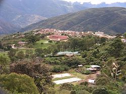
Irupana Municipality

Last updated
Irupana
Municipality
Vista de Irupana.jpg
Irupana
Bolivia adm location map.svg
Red pog.svg
Irupana
Location within Bolivia
Coordinates: 16°30′S67°30′W / 16.500°S 67.500°W / -16.500; -67.500
CountryFlag of Bolivia.svg  Bolivia
Department La Paz Department
Province Sud Yungas Province
Seat Irupana
Government
  MayorClemente Mamani Condorena (2007)
Elevation
5,900 ft (1,800 m)
Population
 (2001)
  Total11,383
Time zone UTC-4 (BOT)
Mururata as seen from Coroico Mount Mururata.jpg
Mururata as seen from Coroico

Irupana Municipality or Villa de Lanza Municipality is the second municipal section of the Sud Yungas Province in the La Paz Department, Bolivia. Its seat is Irupana.

Contents

Geography

The Cordillera Real traverses the municipality. The highest peaks of the municipality is Illimani at 6,438 m (21,122 ft) above sea level. Other mountains are listed below: [1] [2] [3]

Subdivision

Irupana Municipality is divided into six cantons.

CantonInhabitants (2001) [4] SeatInhabitants (2001)
Irupana4,465 Irupana 1,882
Lambate2,693Lambate347
Laza800Laza164
Taca1,080Taca183
Chicaloma1,177 Chicaloma 634
Victorio Lanza1,168Victorio Lanza181

See also

Related Research Articles

Sud Yungas Province Province in La Paz Department, Bolivia

Sud Yungas or Sur Yungas is a province in the Bolivian department of La Paz. It was created during the presidency of José Manuel Pando on January 12, 1900. The capital of the province is Chulumani.

Inquisivi Province Province in La Paz, Bolivia

Inquisivi is a province in the La Paz Department in Bolivia. During the presidency of José Ballivián it was created on November 2, 1844. The capital of the province is Inquisivi.

Larecaja Province Province in La Paz Department, Bolivia

Larecaja is a province in the Bolivian La Paz Department. It was founded by Antonio José de Sucre on October 18, 1826. Its capital is Sorata.

Loayza Province Province in La Paz Department, Bolivia

Loayza or José Ramón Loayza is a province in the La Paz Department, Bolivia. Its seat is Luribay.

Pedro Domingo Murillo Province Province in La Paz Department, Bolivia

Pedro Domingo Murillo is a province in the Bolivian La Paz Department. It was created on January 8, 1838, with the name Cercado and on October 17, 1912, during the presidency of Eliodoro Villazón, its name was changed in honor of Pedro Domingo Murillo, protagonist of the revolution of June 16, 1809.

Cercado Province (Oruro) Province in Oruro, Bolivia

Cercado is a province in the northeastern parts of the Bolivian department of Oruro. Its capital is Oruro. The hamlet of Paria, established in 1535, was the first Spanish settlement in Bolivia and previously had been a regional capital of the Inca Empire. Paria is located in Soracachi municipality.

Sajama Province Province in Oruro, Bolivia

Sajama is a province in the northwestern parts of the Bolivian Oruro Department.

Sorata Municipality Municipality in La Paz Department, Bolivia

Sorata Municipality is the first municipal section of the Larecaja Province in the La Paz Department, Bolivia. Its capital is Sorata. The Illampu - Janq'u Uma massif is located within the municipality, site of the 17th highest lake in the world, Laguna Glaciar.

Batallas Municipality is the third municipal section of the Los Andes Province in the La Paz Department, Bolivia. Its capital is Batallas.

La Paz Municipality, Bolivia Municipality in La Paz Department, Bolivia

La Paz Municipality is the capital municipality and one of the five municipalities of the Pedro Domingo Murillo Province in the La Paz Department in Bolivia. Its seat is La Paz.

Palca Municipality Municipality in La Paz Department, Bolivia

Palca or Pallqa (Aymara) is the first municipal section of the Pedro Domingo Murillo Province in the La Paz Department, Bolivia. Its seat is Palca.

Luribay Municipality Municipality in La Paz Department, Bolivia

Luribay Municipality is the first municipal section of the Loayza Province in the La Paz Department, Bolivia. Its seat is Luribay.

Cairoma Municipality is the fifth municipal section of the Loayza Province in the La Paz Department, Bolivia. Its seat is Cairoma.

Malla Municipality is the fourth municipal section of the Loayza Province in the La Paz Department, Bolivia. Its seat is Malla.

Quime Municipality Municipality in La Paz Department, Bolivia

Quime Municipality is the second municipal section of the Inquisivi Province in the La Paz Department in Bolivia, located south-east of the city of La Paz. Its seat is Quime. The coordinates are 16° 59' 0" South, 67° 13' 0".

Cordillera Quimsa Cruz

The Cordillera Quimsa Cruz is a mountain range in the La Paz Department in Bolivia situated south east of Lake Titicaca and north of Lake Uru Uru, measuring about 35–40 km in length and 12 km at its widest point. It is the continuation of the Cordillera Real of Bolivia extending in a north to south-eastern direction from Asiento pass south of Illimani to Tres Cruces pass.

Mikaya

Mik'aya is a 5,342-metre-high (17,526 ft) mountain in the Cordillera Real in the Andes of Bolivia. It is located in the La Paz Department at the border of the Pedro Domingo Murillo Province, La Paz Municipality, and the Sud Yungas Province, Yanacachi Municipality. Mik'aya lies north-east of the city of La Paz, south-east of the mountains Ch'uñawi and Wak'ani and north of the mountains Jathi Qullu and Sirk'i Qullu.

Chiyar Qullu (Sud Yungas)

Ch'iyar Qullu is a 5,398-metre-high (17,710 ft) mountain in the Cordillera Real in the Andes of Bolivia. It is situated in the La Paz Department, Sud Yungas Province, Irupana Municipality. Ch'iyar Qullu lies south of the mountain Pupusani, north-west of Illimani and south-east of P'iq'iñ Q'ara.

Layqa Qullu

Layqa Qullu is a 6,166-metre-high (20,230 ft) peak in the Cordillera Real in the Andes of Bolivia. It is one of the highest peaks in the Illimani massif. It is situated in the La Paz Department, Murillo Province, Palca Municipality, and in the Sud Yungas Province, Irupana Municipality. Layqa Qullu lies south-east of the highest point of the massif, north-west of Link'u Link'u and Silla Pata.

The Ch'alla Jawira which upstream is named Ch'api K'uchu and downstream successively is called Tupa Jawira and Qura Jawira is a river in the La Paz Department in Bolivia. It is a right affluent of the Aqhuya Jawira whose waters flow to the Desaguadero River.

References

  1. Bolivian IGM map 1:50,000 Araca 6043-I
  2. Bolivian IGM map 1:50,000 Lambate 6044-II
  3. "Irupana". INE, Bolivia. Archived from the original on March 26, 2016. Retrieved March 18, 2016.
  4. www.ine.gob.bo Archived 2011-09-24 at the Wayback Machine

Coordinates: 16°30′S67°30′W / 16.5°S 67.5°W / -16.5; -67.5