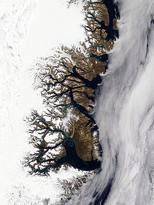
Kaiser Franz Joseph Fjord is a major fjord system in the NE Greenland National Park area, East Greenland.
Frænkel Land is a peninsula in King Christian X Land, East Greenland. Administratively it is part of the Northeast Greenland National Park.

Andrée Land is a peninsula in King Christian X Land, East Greenland that is bounded by Kejser Franz Joseph Fjord, Isfjord and Geologfjord.

King Christian X Land is an area of northeastern Greenland.

Bernstorff Fjord is a fjord in King Frederick VI Coast, eastern Greenland.
The Devil's Castle is a conspicuous mountain rising above the Kaiser Franz Josef Fjord at the SE end of Andrée Land in eastern Greenland. The feature is within the boundaries of Northeast Greenland National Park, currently the largest park on earth.

Waltershausen Glacier is one of the major glaciers in Greenland. It has its terminus on the east coast of the Greenland ice sheet.
Nordfjord is a fjord in the NE Greenland National Park area, East Greenland.
Payer Peak, is a mountain in King Christian X Land, Northeast Greenland. Administratively it is part of the Northeast Greenland National Park zone.
Petermann Peak,, also known as Petermann Fjeld, Petermanns Topp and Petermann Point is a mountain in King Christian X Land, Northeast Greenland. Administratively it is part of the Northeast Greenland National Park zone.
Akuliarutsip Sermerssua, also known as Nordenskiöld Glacier,, is a large glacier located on the east coast of Greenland.

The Antarctic Sound is a sound in King Christian X Land, Northeast Greenland. Administratively it is part of the Northeast Greenland National Park zone.

Suess Land is a peninsula in King Christian X Land, East Greenland. Administratively it is part of the Northeast Greenland National Park.
Louise Boyd Land is an area in King Christian X Land, Eastern Greenland. Administratively it lies in the Northeast Greenland National Park zone. The area is remote and uninhabited.

Bjorne Island, Danish: Bjørneø, meaning 'Bear Island', is an island in NE Greenland. Administratively it belongs to the Northeast Greenland National Park.

Geologfjord is a fjord in King Christian X Land, East Greenland. Administratively it belongs to the Northeast Greenland National Park.
Margaretatop is a mountain in eastern Greenland. Administratively it is part of the Northeast Greenland National Park.
Muskox Fjord is a fjord in King Christian X Land, East Greenland. Administratively it lies in the Northeast Greenland National Park area. This fjord is part of the Kaiser Franz Joseph Fjord system.
Kjerulf Fjord is a fjord in King Christian X Land, eastern Greenland.