
The Mist Trail is one of the most popular short hikes in Yosemite National Park, California, USA. The steep hike follows the Merced River, starting at Happy Isles in Yosemite Valley, past Vernal Fall and Emerald Pool, to Nevada Fall.

McCormick's Creek State Park is the oldest state park in the U.S. state of Indiana, dedicated on July 4, 1916, as part of the state's centennial celebration. It is located 14 miles (23 km) west of Bloomington in Owen County. The park receives about 640,000 visitors annually.

Nevada Fall is a 594-foot (181 m) high waterfall on the Merced River in Yosemite National Park, California. It is located below the granite dome, Liberty Cap, at the west end of Little Yosemite Valley. The waterfall is widely recognized by its "bent" shape, in which the water free-falls for roughly the first third of its length to a steep slick-rock slope. This mid-fall impact of the water on the cliff face creates a turbulent, whitewater appearance in the fall and produces a great deal of mist which covers a wide radius, which led to its current name.
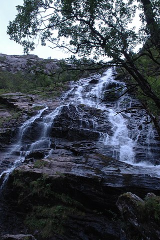
Glen Nevis is a glen in Lochaber, Highland, Scotland, with Fort William at its foot. It is bordered to the south by the Mamore range, and to the north by the highest mountains in the British Isles: Ben Nevis, Càrn Mor Dearg, Aonach Mòr, and Aonach Beag. It is home to one of the three highest waterfalls in Scotland, Steall Falls, where the Allt Coire a'Mhail joins the Water of Nevis in the glen. Below the waterfall is a steeply walled and impressive gorge. The scenic beauty of the glen has led to its inclusion in the Ben Nevis and Glen Coe National Scenic Area, one of 40 such areas in Scotland.

The Laurel Falls Trail is an American hiking trail, in the Great Smoky Mountains National Park of Sevier County, Tennessee. The trail ascends Cove Mountain, leading past Laurel Falls, one of the most popular waterfalls in the national park, en route to the summit of Cove Mountain and the Cove Mountain fire tower.
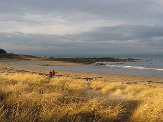
Yellowcraig, also known as Broad Sands Beach, is a coastal area of forest, beach and grassland in East Lothian, south-east Scotland. Yellowcraig is partly within the Firth of Forth Site of Special Scientific Interest (SSSI). It is bordered to the north by the Firth of Forth, to the south by the village of Dirleton and Dirleton Castle, to the east by the North Berwick West Links golf course, and to the west by the Archerfield Estate and Links golf courses.

The Linville Gorge Wilderness is the third largest wilderness area in North Carolina and one of only two wilderness gorges in the Southern United States. Maintained by the United States Forest Service, it comprises 11,786 acres (47.70 km2) around the Linville River, and is situated inside the Pisgah National Forest. The river is approximately 1,400 feet (430 m) below the ridge, thus hiking in and out of the Gorge is challenging and enjoyable for those who like serious hiking. The plant and animal community is extremely diverse, with a dense hardwood/pine forest and a wide variety of smaller trees and other plants as well as bear, fox, raccoon, trout, grouse, wild turkey, vultures, owls, hawks, copperheads, and timber rattlesnakes.
Albion Falls is a 19 m (62 ft) classical/cascade waterfall flowing down the Niagara Escarpment in Red Hill Valley, in Hamilton, Ontario, Canada. With cascade falls the downpour is staggered into a series of steps causing water to "cascade". The top of the falls are located on Mountain Brow Blvd. The lower-end of the falls can be found at the south-end of King's Forest Park in lower Hamilton by following the Red Hill Creek south towards the Niagara Escarpment.

Kaaterskill Falls is a two-stage waterfall on Spruce Creek in the eastern Catskill Mountains of New York, between the hamlets of Haines Falls and Palenville in Greene County. The two cascades total 260 feet in height, making Kaaterskill Falls one of the highest waterfalls in New York, and one of the Eastern United States' tallest waterfalls.

Raven Cliff Falls are located in White County, Georgia on a creek that joins Dodd Creek. The waterfall consists of three drops, a 60-foot (18 m) drop, followed by a 20-foot (6.1 m) drop into a deep pool, followed by a cascade of 20 feet (6.1 m) to Dodd Creek. The waterfall is an unusual double cascade flowing down through a fissure in a massive granite outcrop. There are also three other major waterfalls located on Dodd Creek, with the largest having a 70-foot (21 m) drop.
The John Muir Way is a 215-kilometre (130 mi) continuous long-distance route in southern Scotland, running from Helensburgh, Argyll and Bute in the west to Dunbar, East Lothian in the east. It is named in honour of the Scottish conservationist John Muir, who was born in Dunbar in 1838 and became a founder of the United States National Park Service. The route provides a coast-to-coast route across Scotland, linking Muir's birthplace with Scotland's first national park, Loch Lomond and The Trossachs, and Helensburgh, from where he left Scotland for the United States. It is suitable for walkers and cyclists although some sections are on rougher terrain and may not be suitable for road bicycles.
The John Muir National Recreation Trail (#152) is a 20.7 mile (33.3 km) trail in eastern Tennessee, along the north side of Hiwassee River in the Cherokee National Forest. It is named after naturalist John Muir and was constructed in 1972 through the efforts of the Youth Conservation Corps and the Senior Community Service Employment Program. The trail is said to follow the path taken during Muir's travels from Kentucky to Florida in his book A Thousand Mile Walk to the Gulf. In it, he wrote:
My path all to-day led me along the leafy banks of the Hiwassee, a most impressive mountain river. Its channel is very rough, as it crosses the edges of upturned rock strata, some of them standing at right angles, or glancing off obliquely to right and left. Thus a multitude of short, resounding cataracts are produced, and the river is restrained from the headlong speed due to its volume and the inclination of its bed.
All the larger streams of uncultivated countries are mysteriously charming and beautiful, whether flowing in mountains or through swamps and plains. Their channels are interestingly sculptured, far more so than the grandest architectural works of man. The finest of the forests are usually found along their banks, and in the multitude of falls and rapids the wilderness finds a voice. Such a river is the Hiwassee, with its surface broken to a thousand sparkling gems, and its forest walls vine-draped and flowery as Eden. And how fine the songs it sings!

Chapel Brook of Franklin County, Massachusetts is a tributary of the South River and the name of a 173-acre (70 ha) open space preserve located along the brook. The brook, est. 3.79 mi (6.10 km) long, is located in southeast Ashfield and southwest Conway. It drains into Poland Brook, thence into the South River, the Deerfield River, the Connecticut River, and Long Island Sound. The Chapel Brook reservation, managed by the non-profit conservation organization The Trustees of Reservations, is located in Ashfield and contains Chapel Falls, a series of three waterfalls on Chapel Brook, measuring 10 feet (3.0 m), 15 feet (4.6 m) and 20 feet (6.1 m) high; and Pony Mountain est. 1,400 feet (430 m), a 100-foot (30 m) open granite cliff face and popular recreational rock climbing site.

Eaton Canyon is a major canyon beginning at the Eaton Saddle near Mount Markham and San Gabriel Peak in the San Gabriel Mountains in the Angeles National Forest, United States. Its drainage flows into the Rio Hondo river and then into the Los Angeles River. It is named after Judge Benjamin S. Eaton, who lived in the Fair Oaks Ranch House in 1865 not far from Eaton Creek.

Salt Creek Falls is a cascade and plunge waterfall on Salt Creek, a tributary of the Middle Fork Willamette River, that plunges into a gaping canyon in the Willamette National Forest near Willamette Pass in Lane County, Oregon. The waterfall is notable for its main drop of 286 feet (87 m), ranking third highest among plunge waterfalls in Oregon, after Multnomah Falls and Watson Falls.) The pool at the bottom of Salt Creek Falls waterfall is 66 feet (20 m) deep.

Kaaterskill Clove is a deep gorge, or valley, in New York's eastern Catskill Mountains, lying just west of the village of Palenville and in Haines Falls. The clove was formed by Kaaterskill Creek, a tributary of Catskill Creek rising west of North Mountain, and is estimated by geologists to be as much as 1 million years old. Kaaterskill High Peak and Roundtop Mountain rise to the south of the gorge, while South Mountain is to its north. This makes the gorge as deep as 2,500 feet in places.

The Minyon Falls is a plunge waterfall on Repentance Creek in the Northern Rivers region of New South Wales, Australia. The waterfall descends more than 100 metres (330 ft) over the huge rhyolite cliffs which were once part of the Tweed Volcano. The water flow eroded the rocks to create the waterfall.

The East Highland Way is a long-distance walking route in Scotland that connects Fort William (56.8178°N 5.1109°W) with the ski and mountain resort of Aviemore (57.1899°N 3.8292°W). The route was described by Kevin Langan in 2007. The name is derived from the fact that the route terminates in Aviemore at the eastern edge of Highland region. The EHW route takes in a varied and wild landscape through deep forest plantations, passing many highland lochs and negotiating unspoilt marshlands. The route also explores the ancient Caledonian forests of Inshriach. The walk is 82 miles (132 km) long.
