
The Jamestown settlement in the Colony of Virginia was the first permanent English settlement in the Americas. It was located on the northeast bank of the James River, about 2.5 mi (4 km) southwest of present-day Williamsburg. It was established by the London Company as "James Fort" on May 4, 1607 O.S., and considered permanent, after brief abandonment in 1610. It followed failed attempts, including the Roanoke Colony, established in 1585. Despite the dispatch of more supplies, only 60 of the original 214 settlers survived the 1609–1610 Starving Time. In mid-1610, the survivors abandoned Jamestown, though they returned after meeting a resupply convoy in the James River.

Jamestown Settlement is a living history museum operated by the Commonwealth of Virginia, created in 1957 as Jamestown Festival Park for the 350th anniversary celebration. Today it includes a recreation of the original James Fort, a Powhatan Native American town, indoor and outdoor displays, and replicas of the original settlers' ships: the Susan Constant, Godspeed, and Discovery.

York County is a county in the eastern part of the Commonwealth of Virginia, located in the Tidewater. As of the 2020 census, the population was 70,045. The county seat is the unincorporated town of Yorktown.

Williamsburg is an independent city in Virginia, United States. As of the 2020 census, it had a population of 15,425. Located on the Virginia Peninsula, Williamsburg is in the northern part of the Hampton Roads metropolitan area. It is bordered by James City County on the west and south and York County on the east.

James City County is a county located in the Commonwealth of Virginia. As of the 2020 census, the population was 78,254. Although politically separate from the county, the county seat is the adjacent independent city of Williamsburg.

The Virginia Peninsula is located in southeast Virginia, bounded by the York River, James River, Hampton Roads and Chesapeake Bay. It is sometimes known as the Lower Peninsula to distinguish it from two other peninsulas to the north, the Middle Peninsula and the Northern Neck.
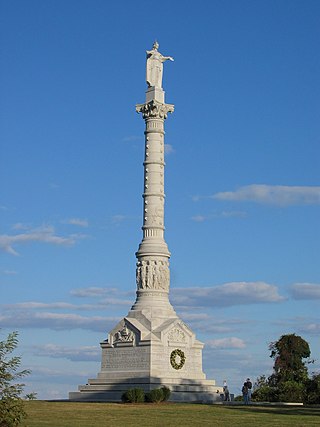
Colonial National Historical Park is a large national historical park located in the Hampton Roads region of Virginia operated by the National Park Service. It protects and interprets several sites relating to the Colony of Virginia and the history of the United States more broadly. These range from the site of the first English settlement at Jamestown, to the battlefields of Yorktown where the British Army was defeated in the American Revolutionary War. Over 3 million people visit the park each year.

The Middle Peninsula is the second of three large peninsulas on the western shore of Chesapeake Bay in Virginia. To the north the Rappahannock River separates it from the Northern Neck peninsula. To the south the York River separates it from the Virginia Peninsula. It encompasses six Virginia counties: Essex, Gloucester, King and Queen, King William, Mathews, and Middlesex. Developed for tobacco plantations in the colonial era, in the 21st century the Middle Peninsula is known for its quiet rural life, vegetable truck-farming, and fishing industry. As of the 2020 census, the Middle Peninsula was home to 92,886 people.

Jamestown Island is a 1,561-acre island in the James River in Virginia, part of James City County. It is located off Glasshouse Point, to which it is connected via a causeway to the Colonial Parkway. Much of the island is wetland, including both swamp and marsh.

Colonial Parkway is a 23-mile (37 km) scenic parkway linking the three points of Virginia's Historic Triangle, Jamestown, Williamsburg, and Yorktown. It is part of the National Park Service's Colonial National Historical Park. Virginia's official state classification for the parkway is State Route 90003. With portions built between 1930 and 1957, it links the three communities via a roadway shielded from views of commercial development. The roadway is toll-free, is free of semi trucks, and has speed limits of around 35 to 45 mph. As a National Scenic Byway and All-American Road, it is also popular with tourists due to the James River and York River ends of the parkway.
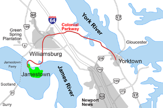
The Historic Triangle includes three historic colonial communities located on the Virginia Peninsula, bounded by the York River on the north and James River on the south. The three points that form the triangle are Jamestown, Colonial Williamsburg, and Yorktown. They feature many restored attractions and are linked by the Colonial Parkway in James City and York counties, and the City of Williamsburg.

The Jamestown Ferry is a free automobile and bus ferry service across a navigable portion of the James River in Virginia. It carries State Route 31, connecting Jamestown in James City County with Scotland Wharf in Surry County.
In the seventeenth century, Kecoughtan was the name of the settlement now known as Hampton, Virginia. In the early twentieth century, it was also the name of a town nearby in Elizabeth City County. It was annexed into the City of Newport News in 1927.
Grove is an unincorporated community in the southeastern portion of James City County in the Virginia Peninsula subregion of Virginia in the United States. It is located in the center of the Historic Triangle of Colonial Virginia, communities linked by the Colonial Parkway. This area is one of the busiest tourist destinations in the world.

Transportation in the Commonwealth of Virginia is by land, sea and air. Virginia's extensive network of highways and railroads were developed and built over a period almost 400 years, beginning almost immediately after the founding of Jamestown in 1607, and often incorporating old established trails of the Native Americans.

The Capitol at Williamsburg, Virginia housed both houses of the Virginia General Assembly, the Governor's Council and the House of Burgesses of the colony of Virginia from 1705, six years after the colonial capital was relocated there from Jamestown, until 1780, when the capital was relocated to Richmond. Two capitol buildings served the colony on the same site: the first from 1705 until its destruction by fire in 1747; the second from 1753 to 1780.

College Creek is located in James City County in the Virginia Peninsula area of the Hampton Roads region of southeastern Virginia in the United States. From a point of origin near the independent city of Williamsburg, it is a tributary of the James River.
Queen's Creek is located in York County in the Virginia Peninsula area of the Hampton Roads region of southeastern Virginia in the United States. From a point of origin near the Waller Mill Reservoir in western York County, it flows northeasterly across the northern half of the Peninsula as a tributary of the York River.

Jamestown Church, constructed in brick from 1639 onward, in Jamestown in the Mid-Atlantic state of Virginia, is one of the oldest surviving building remnants built by Europeans in the original Thirteen Colonies and in the United States overall. It is now part of Historic Jamestown, and is owned by Preservation Virginia. There have been several sites and stages in the church's history, and its later tower is now the last surviving above-ground structure from the days when Jamestown was the capital of Virginia. The current structure, active as part of the Continuing Anglican movement, is still in use today. The ruins are currently being researched by members of the Jamestown Rediscovery project.

Lake Matoaka is a mill pond on the campus of the College of William & Mary in Williamsburg, Virginia, located in the College Woods. Originally known both as Rich Neck Pond for the surrounding Rich Neck Plantation and Ludwell's Mill Pond for Philip Ludwell who owned it, Lake Matoaka was constructed around 1700 to power a gristmill. The pond was renamed after acquisition by the college to bear the Powhatan name for Pocahontas. Construction projects by the Civilian Conservation Corps, college, and others have contributed to the lake becoming a site for outdoor entertainment and recreation.
