Island Park, Idaho

Last updated
Island Park, Idaho
Fremont County Idaho Incorporated and Unincorporated areas Island Park Highlighted 1640600.svg
Location of Island Park in Fremont County, Idaho.
Coordinates: 44°29′59″N111°20′19″W / 44.49972°N 111.33861°W / 44.49972; -111.33861
Country United States
State Idaho
County Fremont
Area
[1]
  Total6.19 sq mi (16.03 km2)
  Land6.08 sq mi (15.75 km2)
  Water0.11 sq mi (0.28 km2)
Elevation
6,293 ft (1,918 m)
Population
 (2010) [2]
  Total286
  Estimate 
(2019) [3]
266
  Density43.74/sq mi (16.89/km2)
Time zone UTC-7 (Mountain (MST))
  Summer (DST) UTC-6 (MDT)
ZIP codes
83429, 83433
Area code 208
FIPS code 16-40600
GNIS feature ID2410121

Island Park is a city in Fremont County, Idaho, United States. The city's population was 286 at the 2010 census, up from 215 in 2000. The city was incorporated by owners of the many lodges and resorts along U.S. Route 20 in 1947, primarily to circumvent Idaho's liquor laws that prohibited the sale of liquor outside of city limits. It is only 500 feet (150 m) wide in most locations yet, at 33 miles (53 km), claims to have the longest "Main Street" in the world.

Contents

Island Park is part of the Rexburg Micropolitan Statistical Area.

Geography

City geography

Island Park is located at 44°29′59″N111°20′19″W / 44.49972°N 111.33861°W / 44.49972; -111.33861 (44.4996, 111.3387), [4] at an elevation of 6,293 feet (1,918 m) above sea level, making it the highest city in Idaho. [5]

According to the United States Census Bureau, the city has a total area of 6.77 square miles (17.53 km2), of which, 6.64 square miles (17.20 km2) is land and 0.13 square miles (0.34 km2) is water. [6]

Regional geography

The area was known as Island Park long before the 33-mile (53 km)-long town was incorporated. [7] The area known as Island Park is mostly a large crater or caldera named the Henry's Fork Caldera that was created by the same hotspot that created the earlier Island Park Caldera and the later Yellowstone Caldera. [8]

Upper Henrys Fork drainage IP Place Names.jpg
Upper Henrys Fork drainage

In addition to the portion which lies on the Henry's Fork Caldera, about a third of what is known as Island Park is north of the caldera, extending across Henry's Lake Flat and Henry's Lake towards the Idaho/Montana border. Henry's Lake Flat is a flat bottomed valley between high mountain ranges, with Henrys Lake at the northwest end of the flats. Mount Jefferson, south of Henry's Lake, is 10,203 feet (3,110 m) high and Targhee Peak, north of Henrys Lake is 10,240 feet (3,121 m) high. The most famous of Island Park's peaks, however, is the 9,886-foot (3,013 m) Sawtell Peak, south of Henrys Lake near Mount Jefferson. The peak is known for its beauty and is named for a perceived resemblance to a Native American chief's profile while napping. The peak has also been called Chief Rains in the Face. Sawtell Peak is topped by a FAA radar dome and is visible from nearly anywhere in Island Park.

Although much smaller than either the Island Park Caldera or the Yellowstone Caldera, the Henry's Fork Caldera is still one of the largest calderas in the world and is the only large caldera in the Yellowstone region that is plainly visible. [9] It has a nearly level 20-mile (32 km) wide circular floor that slopes slightly towards the southeast. The caldera floor is at about 6,000 feet (1,830 m) of elevation with the rim generally being several hundred feet higher. The Henry's Lake Flat area, north of the caldera, is a little higher. Henry's Lake sits at about 6,500 feet (1,980 m), with the flats sloping slightly southward towards the caldera.

The Island Park area is mostly forested with many meadows and grasslands. It is mostly level, but is surrounded by forested hills and high mountains in the north. The Henrys Fork of the Snake River meanders through Island Park with its headwaters at Henry's Lake and at Big Springs (Idaho). The Henry's Fork is impounded by Island Park Dam to form Island Park Reservoir outside the north rim of the caldera. In fact, the entire south bank of Island Park Reservoir is formed by the northern slope of the caldera. The Henry's Fork crosses through the caldera and then cascades off from it at Upper and Lower Mesa Falls.

Mt. Jefferson and Indian Paintbrush JeffersonFlowers.jpg
Mt. Jefferson and Indian Paintbrush
Meadow in Island Park revealing flat bottom of caldera floor, Teton Range in background Meadow in Island Park, Idaho.jpg
Meadow in Island Park revealing flat bottom of caldera floor, Teton Range in background

The geography of Island Park is actually unique and distinctive. It is largely flat and it has unusually high precipitation. Island Park is at the same 6,000 feet (1,830 m) elevation as Teton Valley, Idaho, Jackson Hole, Wyoming, or the Centennial Valley, Montana; yet while these nearby areas are semi-arid prairie or even desert areas receiving less than 12 inches (30 cm) of precipitation annually, Island Park is forested and green with many streams, ponds, lakes, and meadows. Island Park receives well over 30 inches (76 cm) of precipitation annually, with parts receiving over 50 inches (127 cm). That is, Island Park has three times the rainfall and snowfall as nearby areas of the same elevation. [10]

The Snake River Plain that was also formed by the Yellowstone hotspot aligns with the gap between the Sierra Nevada and Cascade mountain ranges along the West Coast of the United States so that there is a moisture channel that extends from the distant Pacific Ocean, between the Cascades and Sierra Nevada, through the Rocky Mountains to Island Park.

This abundant precipitation in Island Park falls on the relatively level floor of the caldera, where it forms numerous meandering streams, ponds, marshes, and meadows. It also falls on the higher areas to the east along the Yellowstone Park border, where it percolates though the granular volcanic deposits to emerge as some of the largest springs in the world. Big Springs, Buffalo River Springs, and Warm River Springs all are 1st Magnitude springs, and they form some of the crystal-clear meandering streams that the area is famous for.

Demographics

Historical population
CensusPop.Note
1930 50
1960 53
1970 136156.6%
1980 15413.2%
1990 1593.2%
2000 21535.2%
2010 28633.0%
2020 193−32.5%
source: [11]

2010 census

As of the census [2] of 2010, there were 286 people, 122 households, and 74 families residing in the city. The population density was 43.1 inhabitants per square mile (16.6/km2). There were 692 housing units at an average density of 104.2 per square mile (40.2/km2). The racial makeup of the city was 96.9% White, 0.7% Native American, 1.7% from other races, and 0.7% from two or more races. Hispanic or Latino of any race were 6.6% of the population.

There were 122 households, of which 19.7% had children under the age of 18 living with them, 55.7% were married couples living together, 2.5% had a female householder with no husband present, 2.5% had a male householder with no wife present, and 39.3% were non-families. 33.6% of all households were made up of individuals, and 5% had someone living alone who was 65 years of age or older. The average household size was 2.28 and the average family size was 2.97.

The median age in the city was 45 years. 19.2% of residents were under the age of 18; 6.2% were between the ages of 18 and 24; 24.4% were from 25 to 44; 34.2% were from 45 to 64; and 15.7% were 65 years of age or older. The gender makeup of the city was 53.5% male and 46.5% female.

2000 census

As of the census [12] of 2000, there were 215 people, 90 households, and 57 families residing in the city. The population density was 34.6 inhabitants per square mile (13.4/km2). There were 425 housing units at an average density of 68.4 per square mile (26.4/km2). The racial makeup of the city was 95.81% White, 0.93% Asian, 2.33% from other races, and 0.93% from two or more races. Hispanic or Latino of any race were 4.19% of the population.

There were 90 households, out of which 22.2% had children under the age of 18 living with them, 55.6% were married couples living together, 6.7% had a female householder with no husband present, and 35.6% were non-families. 27.8% of all households were made up of individuals, and 2.2% had someone living alone who was 65 years of age or older. The average household size was 2.39 and the average family size was 2.93.

In the city, the population was spread out, with 19.5% under the age of 18, 11.2% from 18 to 24, 27.4% from 25 to 44, 28.4% from 45 to 64, and 13.5% who were 65 years of age or older. The median age was 42 years. For every 100 females, there were 112.9 males. For every 100 females age 18 and over, there were 119.0 males.

The median income for a household in the city was $26,250, and the median income for a family was $30,000. Males had a median income of $22,292 versus $16,250 for females. The per capita income for the city was $15,617. About 21.0% of families and 23.9% of the population were below the poverty line, including 37.9% of those under the age of eighteen and none of those 65 or over.

Climate

Island Park has a humid continental climate (Dsb), bordering on a subarctic climate (Dsc). Summer days are usually warm, with nights dropping to temperatures around 40, while winters are very cold, with massive yearly snowfall averaging 215 inches (546 cm). It is the site of Idaho's lowest recorded temperature, −60 °F (−51 °C), on January 18, 1943.

Climate data for Island Park Dam, Idaho, 19912020 normals, extremes 1937present
MonthJanFebMarAprMayJunJulAugSepOctNovDecYear
Record high °F (°C)49
(9)
55
(13)
62
(17)
76
(24)
84
(29)
91
(33)
97
(36)
96
(36)
91
(33)
82
(28)
68
(20)
56
(13)
97
(36)
Mean maximum °F (°C)40.7
(4.8)
43.8
(6.6)
53.3
(11.8)
64.5
(18.1)
75.2
(24.0)
81.8
(27.7)
87.7
(30.9)
87.8
(31.0)
82.8
(28.2)
70.9
(21.6)
54.4
(12.4)
40.7
(4.8)
87.8
(31.0)
Average high °F (°C)26.5
(−3.1)
29.7
(−1.3)
38.6
(3.7)
47.4
(8.6)
59.2
(15.1)
67.3
(19.6)
77.1
(25.1)
77.2
(25.1)
68.0
(20.0)
51.3
(10.7)
35.6
(2.0)
25.5
(−3.6)
50.3
(10.2)
Daily mean °F (°C)16.2
(−8.8)
18.6
(−7.4)
26.5
(−3.1)
35.3
(1.8)
45.4
(7.4)
52.6
(11.4)
60.0
(15.6)
58.6
(14.8)
50.1
(10.1)
37.7
(3.2)
25.0
(−3.9)
16.0
(−8.9)
36.8
(2.7)
Average low °F (°C)5.9
(−14.5)
7.5
(−13.6)
14.5
(−9.7)
23.1
(−4.9)
31.5
(−0.3)
37.8
(3.2)
42.8
(6.0)
40.0
(4.4)
32.2
(0.1)
24.1
(−4.4)
14.3
(−9.8)
6.4
(−14.2)
23.3
(−4.8)
Mean minimum °F (°C)−22.7
(−30.4)
−19.2
(−28.4)
−9.8
(−23.2)
6.1
(−14.4)
20.1
(−6.6)
27.3
(−2.6)
32.9
(0.5)
29.5
(−1.4)
21.4
(−5.9)
9.0
(−12.8)
−8.9
(−22.7)
−19.3
(−28.5)
−28.1
(−33.4)
Record low °F (°C)−60
(−51)
−54
(−48)
−36
(−38)
−18
(−28)
7
(−14)
20
(−7)
25
(−4)
17
(−8)
8
(−13)
−17
(−27)
−34
(−37)
−51
(−46)
−60
(−51)
Average precipitation inches (mm)3.53
(90)
2.64
(67)
2.05
(52)
2.37
(60)
2.99
(76)
2.63
(67)
1.17
(30)
1.14
(29)
1.66
(42)
2.09
(53)
2.54
(65)
4.01
(102)
28.82
(733)
Average snowfall inches (cm)54.2
(138)
36.1
(92)
27.1
(69)
17.7
(45)
2.7
(6.9)
0.3
(0.76)
0.0
(0.0)
0.0
(0.0)
0.2
(0.51)
7.9
(20)
26.7
(68)
61.4
(156)
234.3
(596.17)
Average extreme snow depth inches (cm)44.2
(112)
51.9
(132)
52.1
(132)
37.1
(94)
10.3
(26)
0.0
(0.0)
0.0
(0.0)
0.0
(0.0)
0.1
(0.25)
3.7
(9.4)
12.6
(32)
33.7
(86)
52.6
(134)
Average precipitation days (≥ 0.01 in)12.910.19.28.48.48.75.05.35.26.28.513.3101.2
Average snowy days (≥ 0.1 in)13.010.07.95.31.10.20.00.00.22.47.613.561.2
Source 1: NOAA [13]
Source 2: National Weather Service [14]

Assimilated communities

In addition to the former unincorporated community, Island Park, [15] for which the incorporated city was named, the city either originally included, or subsequently added, several other formerly unincorporated communities:

Transportation

Airport

Island Park is served by Henry's Lake Airport, which is not located within the city limits, but just west and south of the northern end of the city. [16]

Roads

Island Park is currently served by one U.S. Highway and one state highway; and was previously served by another U.S. Highway and another state highway:

Current highways
Former highways

See also

Related Research Articles

<span class="mw-page-title-main">Rich County, Utah</span> County in Utah, United States

Rich County is a county in the U.S. state of Utah. As of the 2020 United States Census, the population was 2,510, making it the third-least populous county in Utah. Its county seat is Randolph, and the largest town is Garden City. The county was created in 1864. It was named for an early LDS apostle, Charles C. Rich.

<span class="mw-page-title-main">Trinity County, California</span> County in California, United States

Trinity County is a county located in the northwestern portion of the U.S. state of California. Trinity County is rugged, mountainous, heavily forested, and lies along the Trinity River within the Salmon and Klamath Mountains. It is also one of three counties in California with no incorporated cities.

<span class="mw-page-title-main">Park County, Wyoming</span> County in Wyoming, United States

Park County is a county in the U.S. state of Wyoming. As of the 2020 United States Census, the population was 29,624. The county seat is Cody.

<span class="mw-page-title-main">Park County, Montana</span> County in Montana, United States

Park County is a county in the U.S. state of Montana. At the 2020 census, the population was 17,191. Its county seat is Livingston. A small part of Yellowstone National Park is in the southern part of the county.

<span class="mw-page-title-main">Gallatin County, Montana</span> County in Montana, United States

Gallatin County is located in the U.S. state of Montana. With its county seat in Bozeman, it is the second-most populous county in Montana, with a population of 118,960 in the 2020 Census.

<span class="mw-page-title-main">Fremont County, Idaho</span> County in Idaho, United States

Fremont County is a county located in the U.S. state of Idaho. As of the 2020 census the county had a population of 13,388. The county seat and largest city is St. Anthony. The county was established in 1893, and was named for the explorer John C. Frémont. Fremont County is part of the Rexburg, Idaho micropolitan area, which is also included in the Idaho Falls metropolitan area.

<span class="mw-page-title-main">Salem, Fulton County, Arkansas</span> City in Arkansas, United States

Salem is the county seat of Fulton County, Arkansas, United States. Salem was first incorporated in 1900. As of the 2010 census the population stood at 1,635.

<span class="mw-page-title-main">Meridian, Idaho</span> City in Idaho, United States

Meridian is a city located in Ada County in the U.S. state of Idaho. As of the 2020 census, the population of Meridian was 117,635, making it the second largest city in the county and Idaho after Boise, the state capital. Meridian is considered the state's fastest-growing city and among the fastest-growing cities in the United States.

<span class="mw-page-title-main">Nampa, Idaho</span> City in Idaho, United States

Nampa is the largest city in Canyon County, Idaho, United States. Its population was 100,200 at the time of the 2020 Census. It is Idaho's third-most populous city. Nampa is about 20 miles (32 km) west of Boise along Interstate 84, and six miles (10 km) west of Meridian. It is the second principal city of the Boise metropolitan area. The name "Nampa" may have come from a Shoshoni word meaning either moccasin or footprint. According to toponymist William O. Bright the name comes from the Shoshoni word /nampai/, meaning "foot".

<span class="mw-page-title-main">Ashton, Idaho</span> City in Idaho, United States

Ashton is a city in Fremont County, Idaho, United States. The population was 1,127 at the 2010 census, and it is part of the Rexburg Micropolitan Statistical Area. The district is noted for seed potato production and bills itself as the world's largest seed potato growing area.

<span class="mw-page-title-main">St. Anthony, Idaho</span> City in Idaho, United States

St. Anthony is a city in and the county seat of Fremont County, Idaho, United States. The population was 3,542 at the 2010 census, up from 3,342 in 2000. It is part of the Rexburg, Idaho Micropolitan Statistical Area.

<span class="mw-page-title-main">Pullman, Washington</span> City in Washington, United States

Pullman is the largest city in Whitman County, located in southeastern Washington within the Palouse region of the Pacific Northwest. The population was 29,799 at the 2010 census, and estimated to be 34,506 in 2019. Originally founded as Three Forks, the city was renamed after industrialist George Pullman in 1884.

<span class="mw-page-title-main">Cody, Wyoming</span> City in Wyoming, United States

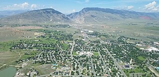
Cody is a city in Northwest Wyoming and the seat of government of Park County, Wyoming, United States. It is named after Buffalo Bill Cody for his part in the founding of Cody in 1896.

<span class="mw-page-title-main">Jackson, Wyoming</span> Town in Wyoming, United States

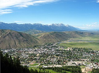
Jackson is a town in Teton County, Wyoming, United States. The population was 10,760 at the 2020 census, up from 9,577 in 2010. It is the largest town in Teton County and its county seat. Jackson is the principal town of the Jackson, WY-ID Micropolitan Statistical Area, which includes Teton County in Wyoming and Teton County in Idaho. The town, often mistakenly called Jackson Hole, derives its name from the valley in which it is located. Jackson is a popular tourist destination due to its proximity to the ski resorts Jackson Hole Mountain, Snow King Mountain, and Grand Targhee, as well as Grand Teton National Park and Yellowstone National Park.

<span class="mw-page-title-main">Henrys Fork (Snake River tributary)</span> River in Idaho, United States

Henrys Fork is a tributary river of the Snake River, approximately 127 miles (204 km) long, in southeastern Idaho in the United States. It is also referred to as the North Fork of the Snake River. Its drainage basin is 3,212 square miles (8,320 km2), including its main tributary, the Teton River. Its mean annual discharge, as measured at river mile 9.2 by the United States Geological Survey (USGS), is 2,096 cubic feet per second (59.4 m3/s), with a maximum daily recorded flow of 79,000 cubic feet per second (2,240 m3/s), and a minimum of 183 cubic feet per second (5.18 m3/s). It is normally transcribed without an apostrophe.

<span class="mw-page-title-main">Island Park Caldera</span> Large caldera in Yellowstone National Park

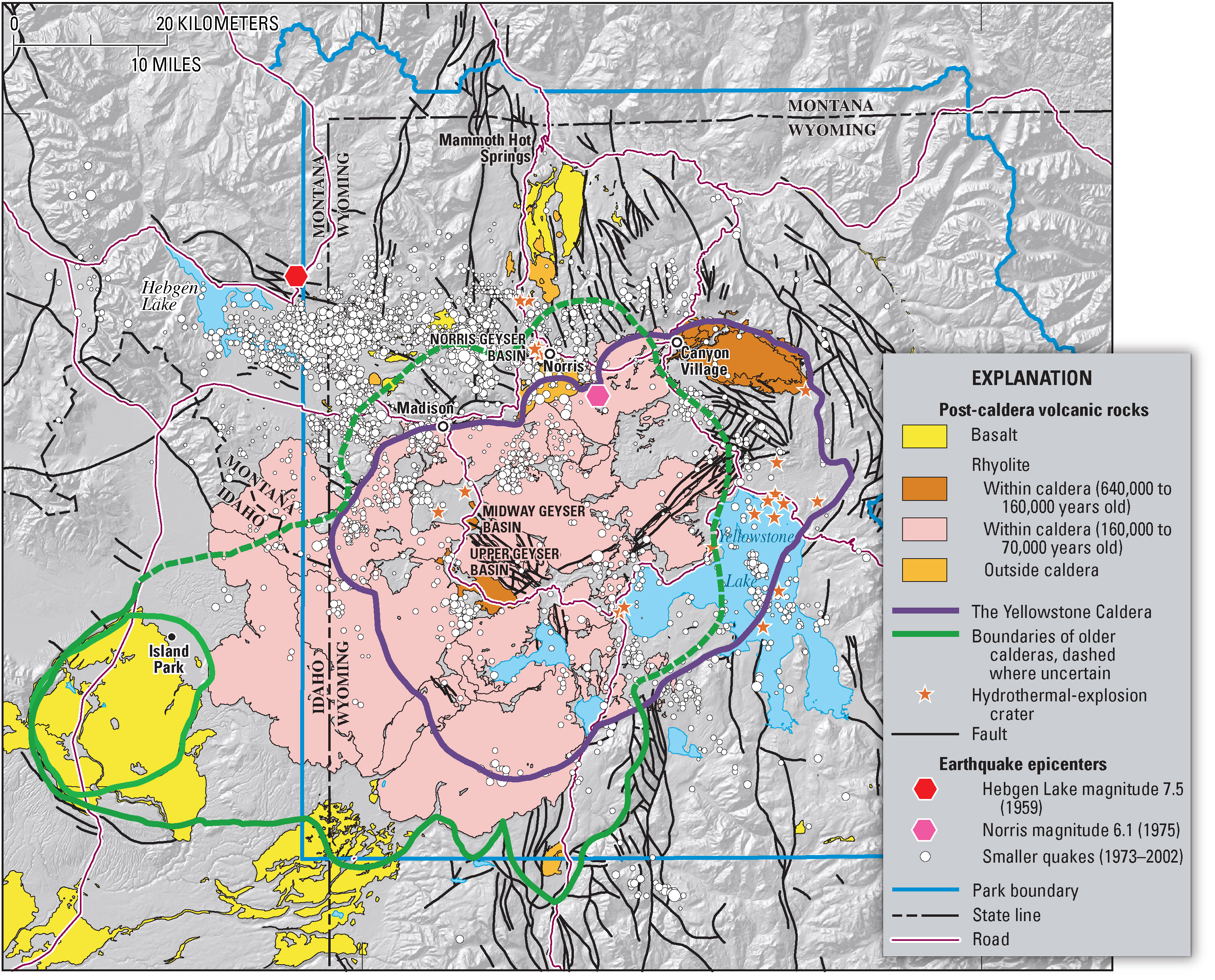
The Island Park Caldera, in the U.S. states of Idaho and Wyoming, is one of the world's largest calderas, with approximate dimensions of 80 by 65 km. Its ashfall is the source of the Huckleberry Ridge Tuff that is found from southern California to the Mississippi River near St. Louis. This super-eruption of approximately 2,500 km3 (600 cu mi) occurred 2.1 Ma and produced 2,500 times as much ash as the 1980 eruption of Mount St. Helens. Island Park Caldera has the smaller and younger Henry's Fork Caldera nested inside it.

<span class="mw-page-title-main">Yellowstone hotspot</span> Volcanic hotspot in the United States

The Yellowstone hotspot is a volcanic hotspot in the United States responsible for large scale volcanism in Idaho, Montana, Nevada, Oregon, and Wyoming, formed as the North American tectonic plate moved over it. It formed the eastern Snake River Plain through a succession of caldera-forming eruptions. The resulting calderas include the Island Park Caldera, Henry's Fork Caldera, and the Bruneau-Jarbidge caldera. The hotspot currently lies under the Yellowstone Caldera. The hotspot's most recent caldera-forming supereruption, known as the Lava Creek Eruption, took place 640,000 years ago and created the Lava Creek Tuff, and the most recent Yellowstone Caldera. The Yellowstone hotspot is one of a few volcanic hotspots underlying the North American tectonic plate; another example is the Anahim hotspot.

<span class="mw-page-title-main">Henry's Fork Caldera</span> Caldera west of Yellowstone National Park

The Henry's Fork Caldera in eastern Idaho is a caldera located in an area known as Island Park, west of Yellowstone National Park. The caldera was formed by an eruption 1.3 million years ago of the Yellowstone hotspot. The eruption distributed at least 280 cubic kilometers of ash known as the Mesa Falls Tuff, covering a region including all of Wyoming and most of Colorado, Nebraska, and Kansas.

<span class="mw-page-title-main">Minidoka Project</span>

The Minidoka Project is a series of public works by the U.S. Bureau of Reclamation to control the flow of the Snake River in Wyoming and Idaho, supplying irrigation water to farmlands in Idaho. One of the oldest Bureau of Reclamation projects in the United States, the project involves a series of dams and canals intended to store, regulate and distribute the waters of the Snake, with electric power generation as a byproduct. The water irrigates more than a million acres (4,000 km²) of otherwise arid land, producing much of Idaho's potato crop. Other crops include alfalfa, fruit and sugar beets. The primary irrigation district lies between Ashton in eastern Idaho and Bliss in the southwestern corner of the state. Five main reservoirs collect water, distributing it through 1,600 miles (2,600 km) of canals and 4,000 miles (6,400 km) of lateral distribution ditches.

References

  1. "2019 U.S. Gazetteer Files". United States Census Bureau. Retrieved July 9, 2020.
  2. 1 2 "U.S. Census website". United States Census Bureau . Retrieved 2012-12-18.
  3. "Population and Housing Unit Estimates". United States Census Bureau. May 24, 2020. Retrieved May 27, 2020.
  4. "US Gazetteer files: 2010, 2000, and 1990". United States Census Bureau. 2011-02-12. Retrieved 2011-04-23.
  5. "Idaho cities by highest elevation". Maps-n-Stats. Archived from the original on 2011-10-10.
  6. "US Gazetteer files 2010". United States Census Bureau. Archived from the original on 2012-07-02. Retrieved 2012-12-18.
  7. Dean H. Green, A History of Island Park, 1990, p. 6.
  8. "Yellowstone map". USGS Publications Repository. Retrieved 14 May 2020.
  9. Wood and Kienle, 1990, Volcanoes of North America: United States and Canada: Cambridge University Press, 354p., p.263-267
  10. NOAA annual precipitation map maker http://nationalatlas.gov/natlas/Natlasstart.asp Archived 2008-12-11 at the Wayback Machine
  11. Moffatt, Riley. Population History of Western U.S. Cities & Towns, 1850-1990. Lanham: Scarecrow, 1996, 94.
  12. "U.S. Census website". United States Census Bureau . Retrieved 2008-01-31.
  13. "U.S. Climate Normals Quick Access – Station: Island Park, ID". National Oceanic and Atmospheric Administration. Retrieved November 29, 2022.
  14. "NOAA Online Weather Data – NWS Pocatello". National Weather Service. Retrieved November 29, 2022.
  15. U.S. Geological Survey Geographic Names Information System: Island Park
  16. "U53: Henry's Lake Airport, Island Park, Idaho, USA". airnav.com. AirNave, LLC. April 23, 2020. Retrieved May 3, 2020.
  17. Island Park, ID (Map). MapQuest . Retrieved 3 May 2020.

Commons-logo.svg Media related to Island Park, Idaho at Wikimedia Commons