Rockall is an uninhabitable granite islet in the North Atlantic Ocean. The United Kingdom claims that Rockall lies within its territorial sea and is part of its territory, but this claim is not recognised by Ireland. It and the nearby skerries of Hasselwood Rock and Helen's Reef are the only emergent parts of the Rockall Plateau. The rock was formed by magmatism as part of the North Atlantic Igneous Province during the Paleogene.
Highland is a council area in the Scottish Highlands and is the largest local government area in the United Kingdom. It was the 7th most populous council area in Scotland at the 2011 census. It shares borders with the council areas of Aberdeenshire, Argyll and Bute, Moray and Perth and Kinross. Their councils, and those of Angus and Stirling, also have areas of the Scottish Highlands within their administrative boundaries.

Cromartyshire is a historic county in the Highlands of Scotland, comprising the medieval "old shire" around the county town of Cromarty and 22 enclaves and exclaves transferred from Ross-shire in the late 17th century. The largest part, six times the size of the old shire, is Coigach, northwest from Ullapool. In 1890, Cromartyshire was merged with Ross-shire into the administrative county of Ross and Cromarty, which in 1975 was merged into the new council area of Highland.
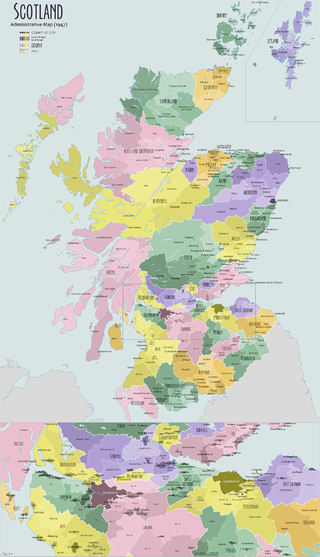
The shires of Scotland, or counties of Scotland, are historic subdivisions of Scotland established in the Middle Ages and used as administrative divisions until 1975. Originally established for judicial purposes, from the 17th century they started to be used for local administration purposes as well. The areas used for judicial functions (sheriffdoms) came to diverge from the shires, which ceased to be used for local government purposes after 1975 under the Local Government (Scotland) Act 1973.

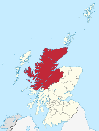
Ross and Cromarty, also referred to as Ross-shire and Cromartyshire, is a variously defined area in the Highlands and Islands of Scotland. There is a registration county and a lieutenancy area in current use, the latter of which is 8,019 square kilometres in extent. Historically there has also been a constituency of the Parliament of the United Kingdom, a local government county, a district of the Highland local government region and a management area of the Highland Council. The local government county is now divided between two local government areas: the Highland area and Na h-Eileanan Siar. Ross and Cromarty border Sutherland to the north and Inverness-shire to the south.

Argyll, sometimes called Argyllshire, is a historic county and registration county of western Scotland.

Muck is the smallest of four main islands in the Small Isles, part of the Inner Hebrides of Scotland. Today, much of the island is used for grazing. Residents use wool to make rugs and clothing. There are several ancient monuments and some facilities for visitors. The few residents are served by a single school, Muck Primary School & Nursery. The island is owned by the MacEwen family.
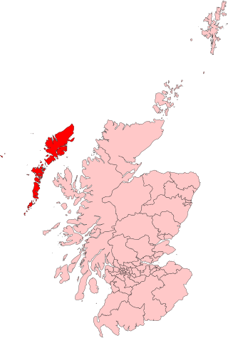
Na h-Eileanan an Iar, formerly Western Isles, is a constituency of the House of Commons of the Parliament of the United Kingdom, created in 1918. It elects one Member of Parliament (MP) by the first past the post system of election.
The Napier Commission, officially the Royal Commission of Inquiry into the Condition of Crofters and Cottars in the Highlands and Islands was a royal commission and public inquiry into the condition of crofters and cottars in the Highlands and Islands of Scotland.
Inverness-shire was a county constituency of the House of Commons of the Parliament of Great Britain from 1708 to 1801 and of the Parliament of the United Kingdom from 1801 until 1918.
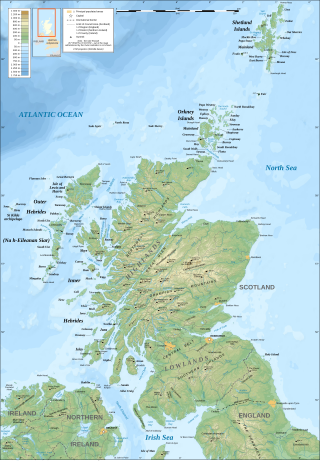
The geography of Scotland is varied, from rural lowlands to unspoilt uplands, and from large cities to sparsely inhabited islands. Located in Northern Europe, Scotland comprises the northern part of the island of Great Britain as well as 790 surrounding islands encompassing the major archipelagos of the Shetland Islands, Orkney Islands and the Inner and Outer Hebrides. The only land border is with England, which runs for 96 miles in a northeasterly direction from the Solway Firth in the west to the North Sea on the east coast. Separated by the North Channel, the island of Ireland lies 13 nautical miles from Mull of Kintyre on the Scottish mainland. Norway is located 190 nmi (350 km) northeast of Scotland across the North Sea. The Atlantic Ocean, which fringes the coastline of western and northern Scotland and its islands, influences the temperate, maritime climate of the country.
Inverness was a county constituency of the House of Commons of the Parliament of the United Kingdom from 1918 until 1983. It elected one Member of Parliament (MP) by the first-past-the-post system of election.

The Northern Constabulary was the territorial police force responsible for Northern Scotland, covering the Highland council area along with the Western Isles, the Orkney Islands and the Shetland Islands, which make up most of the Highlands and Islands area. It was the police force covering the largest geographical area in the United Kingdom, equivalent to the size of Belgium, but was one of the smallest in terms of officers, with about 715 officers. The Constabulary was one of those amalgamated to form Police Scotland in 2013.
The Crofters' Party was the parliamentary arm of the Highland Land League. It gained five MPs in the 1885 general election and a sixth the following year.
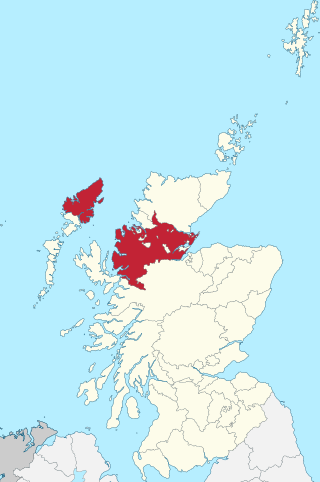
Ross-shire is a historic county in the Scottish Highlands. The county borders Sutherland to the north and Inverness-shire to the south, as well as having a complex border with Cromartyshire – a county consisting of numerous enclaves or exclaves scattered throughout Ross-shire's territory. Ross-shire includes most of Ross along with Lewis in the Outer Hebrides. Dingwall is the traditional county town. The area of Ross-shire is based on that of the historic province of Ross, but with the exclusion of the many enclaves that form Cromartyshire.
A council area is one of the areas defined in Schedule 1 of the Local Government etc. (Scotland) Act 1994 and is under the control of one of the local authorities in Scotland created by that Act.

Inverness-shire or the County of Inverness is a historic county, registration county and lieutenancy area of Scotland. Covering much of the Highlands and Outer Hebrides, it is Scotland's largest county, though one of the smallest in population, with 67,733 people or 1.34% of the Scottish population.