The Vézère is a 211-km-long river in southwestern France. It is an important tributary to the Dordogne. Its source is in the northwestern part of the elevated plateau known as the Massif Central. It flows into the Dordogne near Le Bugue. A tributary of the Vézère is the Corrèze.

The Baïse is a 188-kilometre (117 mi) long river in south-western France, left tributary of the Garonne. Its source is in the foothills of the Pyrenees, near Lannemezan. It flows north through the following départements and towns:

Libourne is a commune in the Gironde department in Nouvelle-Aquitaine in southwestern France. It is a sub-prefecture of the department.

Gourdon is a commune in the Lot department in south-western France.

The arrondissement of Libourne is an arrondissement of France in the Gironde department in the Nouvelle-Aquitaine region. It has 129 communes. Its population is 154,067 (2016), and its area is 1,282.9 km2 (495.3 sq mi).

Argentat is a former commune in the Corrèze department in the Nouvelle-Aquitaine region of central France. On 1 January 2017, it was merged into the new commune Argentat-sur-Dordogne.
Football Club Libourne, formerly known as AS Libourne or Libourne Saint-Seurin-sur-L'Isle, is a French football team from the town of Libourne in Nouvelle-Aquitaine. The club plays in the Championnat National 3, the fifth tier of French football.
The Dronne is a 201-kilometre (125 mi) long river in southwestern France, right tributary of the Isle. Its source is in the north-western Massif Central, east of the town of Châlus at an elevation of 510 metres (1,670 ft). It flows south-west through the following départements and towns:

The Cère is a 120.4 km (75 mi) long river in south-western France, left tributary of the Dordogne. Its source is in the south-western Massif Central, near the mountain Plomb du Cantal. It flows generally west through the following départements and towns:

Allemans is a commune in the Dordogne department in Nouvelle-Aquitaine in southwestern France.

The Loue is a 51 km long river in the Nouvelle-Aquitaine region of France. It is a tributary of the Isle, itself a tributary of the Dordogne.

The Auvézère is a 112 km long river in the region Nouvelle-Aquitaine, France. It is a tributary of the river Isle, which is itself a tributary of the Dordogne.

Fronsac is a commune in the Gironde department in the Nouvelle-Aquitaine region in southwestern France. The town gave its name to the Fronsac AOC wine.
Cénac-et-Saint-Julien is a commune in the Dordogne department in Nouvelle-Aquitaine in southwestern France.

Sarliac-sur-l'Isle is a commune in the Dordogne department in Nouvelle-Aquitaine in southwestern France.

Saint-Vincent-de-Pertignas is a commune in the Gironde department in Nouvelle-Aquitaine in southwestern France.

The Maronne is a 92.6-kilometre (57.5 mi) long river in the Cantal and Corrèze departments in south central France. Its source is several small streams joining near Récusset, a hamlet in Saint-Paul-de-Salers. It flows generally west. It is a left tributary of the Dordogne, into which it flows between Argentat and Monceaux-sur-Dordogne.
The Luzège is a 64.2 km (39.9 mi) long river in the Corrèze département, south-central France. Its source is on the Plateau de Millevaches, in Meymac, 7 km (4.3 mi) north-northwest of the town. It flows generally south. It is a right tributary of the Dordogne into which it flows between Soursac and Laval-sur-Luzège.

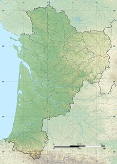
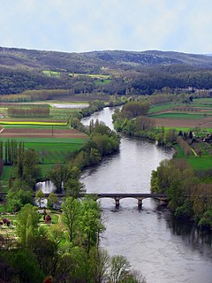
The Dordogne is a river in south-central and southwest France. It is 483.1 km (300.2 mi) long. The Dordogne and its watershed were designated Biosphere Reserve by UNESCO on July 11 2012.

Argentat-sur-Dordogne is a commune in the department of Corrèze, south-central France. The municipality was established on 1 January 2017 by merger of the former communes of Argentat and Saint-Bazile-de-la-Roche.