Israeli occupation of the Golan Heights

Last updated

Historical borders and boundaries of the Golan Heights GolanHistoricalBorders.svg
Historical borders and boundaries of the Golan Heights

The Golan Heights are a rocky plateau in the Levant region of Western Asia that was captured by Israel from Syria in the 1967 Six-Day War. The international community, with the exception of Israel and the United States, generally regards the Golan Heights to be Syrian territory held by Israel under military occupation. [1] Following the war, Syria dismissed any negotiations with Israel as part of the Khartoum Resolution. [2]

Contents

The Golan was under military administration until the Knesset passed the Golan Heights Law in 1981, which applied Israeli law to the territory; a move that has been described as an annexation. In response, the United Nations Security Council unanimously passed UNSC Resolution 497 which condemned the Israeli actions to change the status of the territory declaring them "null and void and without international legal effect", and that the Golan remained an occupied territory. In 2019, the United States became the only state to recognize the Golan Heights as Israeli sovereign territory, while the rest of the international community continues to consider the territory Syrian held under Israeli military occupation. [3] [4]

British and French Mandates

Following World War I, portions of the former territory of the Ottoman Empire was split into several League of Nations mandates under the control of one of the victorious Allied countries of the war. The British Mandate for Palestine and the French Mandate for Syria were two such mandates, with the border finalized between the two in the Paulet–Newcombe Agreement. The border, drawn in 1923, was the first international border between Syria and Palestine and to date is the last, [5] with the remaining boundaries since then having been a result of armistice agreements. The boundary placed the entirety of the Sea of Galilee, along with a ten meter wide strip on the eastern shore, within the British Mandate. [6] The French Mandate ended in 1946 with the independence of the Republic of Syria, and Syria demanded changes to the border to allow for greater access to fresh water sources, demands the British refused on the basis that the border had been submitted and approved to the League of Nations and Britain thus considered the matter closed. [7]

Post-mandate period

The 1948 Arab–Israeli War, which followed Israel's declaration of independence, resulted in the newly formed state of Israel in control over roughly 77% of what had been the territory of the British Mandate. [8] Syria had however advanced to the eastern shoreline of the Sea of Galilee, where the border as delineated by the British and the French was ten meters east of the shoreline. [9] [6] In the armistice negotiations that followed the declaration of a ceasefire, that ten meter strip was included in a demilitarized zone as Israel had argued for. [10]

Six-Day War and aftermath

In the 1967 Six-Day War, Israel captured and occupied a majority of the Golan Heights from Syria. Following the war, the United Nations Security Council passed Resolution 242, which called on Israel to withdraw from territories occupied in the war in exchange for the termination of all states of belligerency and recognition of Israel as a sovereign state by the Arab states. [11] The 1973 Arab-Israeli War saw further territorial gains by Israel, though Israel agreed to return to the 1967 ceasefire line in the 1974 disengagement agreement between Israel and Syria. [12] Syria has continued to insist on the return of the Golan in any negotiated peace agreement between the two countries. [13]

Golan Heights Law

On 14 December 1981 the Israeli Knesset passed the Golan Heights Law. While the law did not use the term annexation, it was considered to be an annexation by the Israeli opposition and international community. [14] [15]

The action was condemned internationally, and in response the United Nations Security Council passed United Nations Security Council Resolution 497 declaring the law "null and void and without international legal effect" and that the Fourth Geneva Convention continued to apply to the Golan as an occupied territory. [16] [17] [18]

International views

The international community, with the exception of Israel and the United States, regards the Golan to be Syrian territory held under Israeli occupation. [19] [18] [20] A number of states recognize the Israeli occupation as being legitimate under the United Nations Charter on a self-defense basis, but do not consider those concerns to allow for the annexation of territory seized by force. [18]

In March 2019, the United States, which previously considered the Golan Heights to be occupied, became the first country to recognize Israeli sovereignty over the territory it has held since 1967. The rest of the international community continues to view the territory as Syrian, held under Israeli occupation. [3] [4] The European Union members of the United Nations Security Council issued a joint statement condemning the US announcement and the UN Secretary-General António Guterres issued a statement saying that the status of the Golan Heights had not changed. [21] [22] [23] The Arab League denounced the US move, declaring that  "Trump's recognition does not change the area's status." [24]

See also

Related Research Articles

<span class="mw-page-title-main">United Nations Security Council Resolution 242</span> 1967 resolution on withdrawal of Israel and recognition of boundaries

United Nations Security Council Resolution 242 (S/RES/242) was adopted unanimously by the UN Security Council on November 22, 1967, in the aftermath of the Six-Day War. It was adopted under Chapter VI of the UN Charter. The resolution was sponsored by British ambassador Lord Caradon and was one of five drafts under consideration.

<span class="mw-page-title-main">Palestinian territories</span> Occupied Palestinian territory in the Middle East

The Palestinian territories are the two regions of the former British Mandate for Palestine that have been occupied by Israel since the Six-Day War of 1967, namely the West Bank and the Gaza Strip. The International Court of Justice (ICJ) has referred to the West Bank, including East Jerusalem, as "the Occupied Palestinian Territory", and this term was used as the legal definition by the ICJ in its advisory opinion of July 2004. The term occupied Palestinian territory was used by the United Nations and other international organizations between October 1999 and December 2012 to refer to areas controlled by the Palestinian National Authority, but from 2012, when Palestine was admitted as one of its non-member observer states, the United Nations started using exclusively the name State of Palestine. The European Union (EU) also uses the term "occupied Palestinian territory". The government of Israel and its supporters use the label "disputed territories" instead.

<span class="mw-page-title-main">Shebaa Farms</span> Small disputed territory between Lebanon and Israel

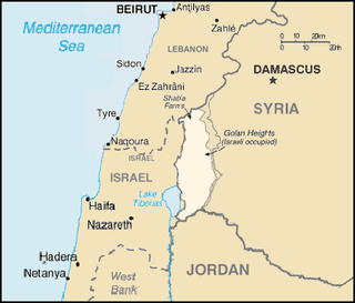
The Shebaa Farms, also spelled Sheba'a Farms, is a small strip of land at the intersection of the Lebanese–Syrian border and the Israeli-occupied Golan Heights. The territory is named for the farms within it which were historically tended by the inhabitants of the Lebanese town of Shebaa. It is about 11 kilometres (7 mi) long and 2.5 kilometres (2 mi) wide.

<span class="mw-page-title-main">United Nations Security Council Resolution 446</span> United Nations resolution adopted in 1979

United Nations Security Council resolution 446, adopted on 22 March 1979, concerned the issue of Israeli settlements in the "Arab territories occupied by Israel since 1967, including Jerusalem". This refers to the Palestinian territories of the West Bank, East Jerusalem and the Gaza Strip as well as the Syrian Golan Heights.

<span class="mw-page-title-main">United Nations Security Council Resolution 497</span> United Nations Security Council resolution negating Golan Heights Law

United Nations Security Council resolution 497, adopted unanimously on 17 December 1981, declared that the Israeli Golan Heights Law, which effectively annexed the Golan Heights, is "null and void and without international legal effect" and further calls on Israel to rescind its action.

The International law bearing on issues of Arab–Israeli conflict, which became a major arena of regional and international tension since the birth of Israel in 1948, resulting in several disputes between a number of Arab countries and Israel.

The Green Line, (pre-)1967 border, or 1949 Armistice border is the demarcation line set out in the 1949 Armistice Agreements between the armies of Israel and those of its neighbors after the 1948 Arab–Israeli War. It served as the de facto borders of the State of Israel from 1949 until the Six-Day War in 1967, and continues to represent Israel’s internationally recognized borders with the two Palestinian territories: the West Bank and the Gaza Strip.

<span class="mw-page-title-main">Israeli-occupied territories</span> Territories presently occupied by Israel since the 1967 Six-Day War

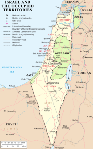
Israel has occupied the Palestinian territories and the Golan Heights since the Six-Day War of 1967. It previously occupied the Sinai Peninsula and southern Lebanon as well. Prior to Israel's victory in the Six-Day War, occupation of the Palestinian territories was split between Egypt and Jordan, with the former having occupied the Gaza Strip and the latter having annexed the West Bank; the Sinai Peninsula and the Golan Heights were under the sovereignty of Egypt and Syria, respectively. The first conjoined usage of the terms "occupied" and "territories" with regard to Israel was in United Nations Security Council Resolution 242, which was drafted in the aftermath of the Six-Day War and called for: "the establishment of a just and lasting peace in the Middle East" to be achieved by "the application of both the following principles: ... Withdrawal of Israeli armed forces from territories occupied in the recent conflict ... Termination of all claims or states of belligerency and respect for and acknowledgment of the sovereignty, territorial integrity and political independence of every State in the area and their right to live in peace within secure and recognized boundaries free from threats or acts of force."

The status of territories captured by Israel is the status of the Gaza Strip, the West Bank, the Golan Heights, and the Sinai Peninsula, all of which were captured by Israel during the 1967 Six-Day War.

The Golan Heights Law is the Israeli law which applies Israel's government and laws to the Golan Heights. It was ratified by the Knesset by a vote of 63―21, on December 14, 1981. Although the law did not use the term, it was considered by the international community and some members of the Israeli opposition as an annexation of the territory and illegitimate.

<span class="mw-page-title-main">United Nations Disengagement Observer Force</span> Peacekeeping mission overseeing Israeli–Syrian ceasefire

The United Nations Disengagement Observer Force (UNDOF) is a United Nations peacekeeping mission tasked with maintaining the ceasefire between Israel and Syria in the aftermath of the 1973 Yom Kippur War. The mission was established by United Nations Security Council Resolution 350 on 31 May 1974, to implement Resolution 338 (1973) which called for an immediate ceasefire and implementation of United Nations Security Council Resolution 242.

<span class="mw-page-title-main">Ghajar</span> Village on the Lebanese-Syrian border

Ghajar, also Rhadjar, is an Alawite-Arab village on the Hasbani River, on the border between Lebanon and the Israeli-occupied portion of the Golan Heights. In 2021, it had a population of 2,745.

<span class="mw-page-title-main">Golan Heights</span> Syrian territory occupied by Israel since 1967

The Golan Heights, or simply the Golan, is a region in the Levant spanning about 1,800 km2 (690 sq mi). The region defined as the Golan Heights differs between disciplines: as a geological and biogeographical region, the term refers to a basaltic plateau bordered by the Yarmouk River in the south, the Sea of Galilee and Hula Valley in the west, the Anti-Lebanon with Mount Hermon in the north and Wadi Raqqad in the east. As a geopolitical region, it refers to the border region captured from Syria by Israel during the Six-Day War of 1967; the territory has been occupied by the latter since then and was subject to a de facto Israeli annexation in 1981. This region includes the western two-thirds of the geological Golan Heights and the Israeli-occupied part of Mount Hermon.

<span class="mw-page-title-main">Borders of Israel</span> Political boundaries between Israel and neighboring states

The modern borders of Israel exist as the result both of past wars and of diplomatic agreements between the State of Israel and its neighbours, as well as an effect of the agreements among colonial powers ruling in the region before Israel's creation. Only two of Israel's five total potential land borders are internationally recognized and uncontested, while the other three remain disputed; the majority of its border disputes are rooted in territorial changes that came about as a result of the 1967 Arab–Israeli War, which saw Israel occupy large swathes of territory from its rivals. Israel's two formally recognized and confirmed borders exist with Egypt and Jordan since the 1979 Egypt–Israel peace treaty and the 1994 Israel–Jordan peace treaty, while its borders with Syria, Lebanon and the Palestinian territories remain internationally defined as contested.

<span class="mw-page-title-main">Annexation</span> Concept in political science

Annexation, in international law, is the forcible acquisition and assertion of legal title over one state's territory by another state, usually following military occupation of the territory. In current international law, it is generally held to be an illegal act. Annexation is a unilateral act where territory is seized and held by one state, as distinct from conquest, and differs from cession, in which territory is given or sold through treaty.

The international community considers the establishment of Israeli settlements in the Israeli-occupied territories illegal on one of two bases: that they are in violation of Article 49 of the Fourth Geneva Convention, or that they are in breach of international declarations. The United Nations Security Council, the United Nations General Assembly, the International Committee of the Red Cross, the International Court of Justice and the High Contracting Parties to the Convention have all affirmed that the Fourth Geneva Convention applies to the Israeli-occupied territories.

<span class="mw-page-title-main">Al-Marsad</span> Human rights organization

Al-Marsad – Arab Human Rights Centre in Golan Heights is an independent, not-for-profit international human rights organization with no religious or political affiliation that operates in the Golan Heights. The Golan Heights region is internationally recognised by all but the US as Syrian territory occupied by Israel, although Israel asserts it has a right to retain control over the area. The organisation was created in October 2003 and is run from Majdal Shams. It was the first human rights organisation founded in the Golan.

<span class="mw-page-title-main">United States recognition of the Golan Heights as part of Israel</span> 2019 U.S. recognition of Israeli sovereignty over Syrias Golan Heights

On March 25, 2019, the United States officially recognized the Golan Heights as being under the sovereignty of Israel. Signed into effect by the Trump administration, the U.S. presidential proclamation marked the first instance of any country recognizing Israeli sovereignty over the Golan Heights; the territory is viewed as part of Syria under international law, though it has been under an Israeli military occupation since the 1967 Arab–Israeli War. In 1981, Israel's government passed the Golan Heights Law — a de facto annexation of the territory.

References

  1. "United Nations General Assembly Resolution A/RES/78/77" (PDF). UN. 11 December 2023. Retrieved 24 January 2024.
  2. "This Week in History: The Arab League Three No's". Jerusalem Post . Retrieved 4 December 2017.
  3. 1 2 Aji, Albert (26 March 2019). "Trump acceptance of Israeli control of Golan sparks protests". Associated Press. Retrieved 29 March 2019.
  4. 1 2 "Trump's Golan move unites Gulf States and Iran in condemnation". France 24. 26 March 2019. Retrieved 31 March 2019.
  5. Kipnis, Yigal (2013). The Golan Heights: Political History, Settlement and Geography since 1949. Routledge Studies in Middle Eastern Politics. Taylor & Francis. p. 235. ISBN   978-1-136-74092-3 . Retrieved 29 March 2019.
  6. 1 2 Balanche, F. (2017). Atlas of the Near East: State Formation and the Arab-Israeli Conflict, 1918-2010. Brill. p. 114. ISBN   978-90-04-34518-8 . Retrieved 29 March 2019.
  7. Capinera, John (2019). Israel And Syria: Peace And Security On The Golan. Taylor & Francis. p. 27. ISBN   978-0-429-71086-5 . Retrieved 29 March 2019.
  8. Oberschall, A. (2007). Conflict and Peace Building in Divided Societies: Responses to Ethnic Violence. Taylor & Francis. p. 129. ISBN   978-1-134-12814-3 . Retrieved 29 March 2019.
  9. Cordesman, Anthony (2008). Israel and Syria : the military balance and prospects of war. Praeger Security International Published in cooperation with the Center for Strategic and International Studies. p. 222. ISBN   978-0-313-35520-2. OCLC   615600412 . Retrieved 29 March 2019.
  10. Ben-Dror, Elad (2015). Ralph Bunche and the Arab-Israeli Conflict: Mediation and the UN, 1947-1949. Israeli History, Politics and Society. Taylor & Francis. p. 234. ISBN   978-1-317-65470-4 . Retrieved 29 March 2019.
  11. Zacher, Mark (1 June 2001). "The Territorial Integrity Norm: International Boundaries and the Use of Force". International Organization. Cambridge University Press (CUP). 55 (2): 231–232. doi:10.1162/00208180151140568. ISSN   1531-5088. JSTOR   3078631. S2CID   154890372.
  12. Rabinovich, Itamar (2009). The Brink of Peace: The Israeli-Syrian Negotiations. Princeton University Press. p. 28. ISBN   978-1-4008-2265-2 . Retrieved 29 March 2019.
  13. Ehteshami, Anoushiravan; Hinnebusch, Raymond (2002). Syria and Iran: Middle Powers in a Penetrated Regional System. Taylor & Francis. pp. 160–161. ISBN   978-1-134-73021-6 . Retrieved 29 March 2019.
  14. Israeli Ministry of Foreign Affairs. Golan Heights Law.
  15. Rabinowitz, Dan (28 March 2012). "17: Identity, the State and Borderline Disorder". In Thomas M. Wilson and Hastings Donnan (ed.). A Companion to Border Studies. John Wiley & Sons. pp. 307–308. ISBN   978-1-118-25525-4.
  16. Council on Foreign Relations. UN Security Council Resolution 497.
  17. Benvenisti, E. (2012). The International Law of Occupation. OUP Oxford. ISBN   978-0-19-163957-9 . Retrieved 1 April 2019.
  18. 1 2 3 Korman, Sharon (31 October 1996), The Right of Conquest: The Acquisition of Territory by Force in International Law and Practice, Oxford University Press, pp. 262–264, ISBN   9780191583803
  19. Roberts, Adam (January 1990). "Prolonged Military Occupation: The Israeli-Occupied Territories Since 1967". American Journal of International Law . 84 (1): 60. doi:10.2307/2203016. JSTOR   2203016.
  20. Pileggi, Tamar; Winer, Stuart; Newman, Marissa; Bachner, Michael (28 March 2019). "US redrawing official maps to include Golan as part of Israel". The Times of Israel. Retrieved 2 April 2019.
  21. "Trump recognizes Golan Heights as Israeli, boosting Netanyahu and angering Syria". Reuters. 25 March 2019. Retrieved 25 March 2019.
  22. "U.N. chief clear that Golan status has not changed: spokesman". 25 March 2019 via www.reuters.com.
  23. Fassihi, Farnaz (28 March 2019). "Security Council Denounces Trump's Golan Decision". WSJ. Retrieved 29 March 2019.
  24. "Trump formally recognises Israeli sovereignty over Golan Heights". www.aljazeera.com. Retrieved 2 April 2019.