
Iberville Parish is a parish located south of Baton Rouge in the U.S. state of Louisiana. As of the 2010 census, the population was 33,387. Its seat is Plaquemine. The parish was formed in 1807.
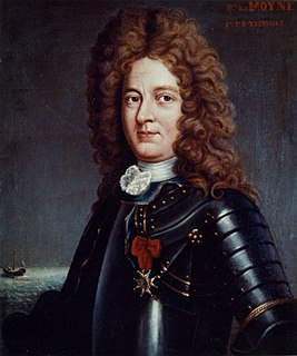
Pierre Le Moyne d'Iberville was a soldier, ship captain, explorer, colonial administrator, knight of the order of Saint-Louis, adventurer, privateer, trader, member of Compagnies Franches de la Marine and founder of the French colony of La Louisiane of New France. He was born in Montreal of French colonist parents.
The Pascagoula were an indigenous group living in coastal Mississippi on the Pascagoula River.

Jean-Baptiste Le Moyne de Bienville, also known as Sieur de Bienville, was a colonist, born in Montreal, New France, and an early, repeated governor of French Louisiana, appointed four separate times during 1701–1743. A younger brother of explorer Pierre Le Moyne d'Iberville.
Pierre Dugué de Boisbriand was a Canadian who commanded several areas in North America colonized by France in the early 18th Century, rising to become the fourth governor of the French colony of Louisiana.

The Houma are a historic Native American people of Louisiana on the east side of the Red River of the South. Their descendants, the Houma people or organization "The United Houma Nation", have been recognized by the state as a tribe since 1972 and not yet by the federal government.

The Old Mobile Site was the location of the French settlement La Mobile and the associated Fort Louis de La Louisiane, in the French colony of New France in North America, from 1702 until 1712. The site is located in Le Moyne, Alabama, on the Mobile River in the Mobile-Tensaw River Delta. The settlement served as the capital of French Louisiana from 1702 until 1711, when the capital was relocated to the site of present-day Mobile, Alabama. The settlement was founded and originally governed by Pierre Le Moyne d'Iberville. Upon the death of d'Iberville, the settlement was governed by his younger brother, Jean-Baptiste Le Moyne de Bienville. The site can be considered a French colonial counterpart to the English settlement at Jamestown, Virginia. The settlement site and fort were listed on the National Register of Historic Places on May 6, 1976. The Old Mobile Site was determined eligible for designation as a National Historic Landmark on January 3, 2001.

Fort Maurepas, later known as Old Biloxi, was developed in colonial French Louisiana in April 1699 along the Gulf of Mexico. . Fort Maurepas was designated temporarily as the capital of Louisiana in 1719. The capital was being moved from Mobile up the Mississippi River to New Orleans to protect it from hurricanes. Government buildings in the latter city were still under construction.
Bayou Manchac is an 18-mile-long (29 km) bayou in southeast Louisiana, USA. First called the Iberville River by its French discoverers, the bayou was once a very important waterway linking the Mississippi River to the Amite River. East Baton Rouge Parish lies on its northern side, while its southern side is divided between Ascension Parish and Iberville Parish. The large unincorporated community of Prairieville and the city of St. Gabriel both lie on its southern side. Dr John R. Swanton a linguist who worked with Native American languages suggested that the name Manchac is derived from Imashaka which is a Choctaw word meaning "the rear entrance".
The Tangipahoa were a Native American tribe that lived just north of Lake Pontchartrain and between the Pearl River and the Mississippi River. The word Tangipahoa (tonche pahoha) is believed to mean "corncob people" or "people of the corn" or "corncob". It is from this Native American tribe that the modern Tangipahoa Parish gets its name, as well as the Tangipahoa River and the village of Tangipahoa.
Baton Rouge offers a wide range of educational and cultural opportunities including being the home to three major universities and colleges and a variety of public and private schools.
Istrouma Area Council serves Scouts in both Louisiana and Mississippi, primarily in the Greater Baton Rouge Area and Florida Parishes. Specifically, the council includes Scouts from the following parishes: Ascension, East Baton Rouge, West Baton Rouge, East Feliciana, West Feliciana, Iberville, Pointe Coupee, St. Helena, St. James, St. Tammany, Washington, and Tangipahoa. Wilkinson County is the sole Mississippi county in the council.
The Historic Roman Catholic Properties in Mobile Multiple Property Submission is a multiple property submission of Roman Catholic properties in Mobile, Alabama, that were listed together on the National Register of Historic Places. The submission covers cemetery, church, convent and other religious properties that are historically or architecturally significant.

Talisheek is an unincorporated community in St. Tammany Parish, Louisiana, United States. Talisheek is located on Louisiana Highway 435, 14 miles (23 km) east-northeast of Covington. Talisheek has a post office with ZIP code 70464.
Bayou Latenache is an unincorporated community in Pointe Coupee Parish, Louisiana, United States. The name may derive from the French latanier or latamacha, Choctaw for "boggy river."
Chinchuba is an unincorporated community in St. Tammany Parish, Louisiana, United States.
Bonfouca is an unincorporated community in St. Tammany Parish, Louisiana, United States. It is on Louisiana Highway 433 adjacent to Liberty Bayou two miles west of Slidell.
The Mougoulacha were a Native American tribe that lived near Lake Pontchartrain.

Fort Bute (1766-1779) was a colonial fort built by the British in 1766 to protect the confluence of Bayou Manchac with the Mississippi River and was named in honor of the Earl of Bute. Fort Bute was located on Bayou Manchac, about 115 miles (185 km) up the Mississippi River from New Orleans, on the far western border of British West Florida. It was one of the three outposts maintained by the British in the lower Mississippi along with Fort Panmure and the Baton Rouge outpost.
Antoine Le Moyne de Châteauguay was a French soldier and colonial administrator who assisted in the foundation of the French colony of Louisiana in 1699–1702. He served in various posts in Mobile, Louisiana and Martinique. He was governor of Cayenne from 1738 to 1743, then governor of Île Royale from 1745 until his death in 1747.


