Supermarine was a British aircraft manufacturer that produced the Spitfire fighter plane, and a range of seaplanes and flying boats. The company had successes in the Schneider Trophy for seaplanes, with three wins in a row of 1927, 1929 and 1931.
Poole Harbour is a large natural harbour in Dorset, southern England, with the town of Poole on its shores. The harbour is a drowned valley (ria) formed at the end of the last ice age and is the estuary of several rivers, the largest being the Frome. The harbour has a long history of human settlement stretching to pre-Roman times. The harbour is extremely shallow, with one main dredged channel through the harbour, from the mouth to Holes Bay.

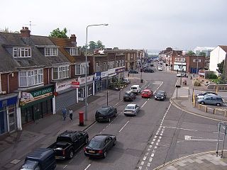
Hythe is a town near Southampton, Hampshire, England. It is located by the shore of Southampton Water, and has a ferry service connecting it to Southampton. Hythe has a small shopping area, a pier, and a marina for yachts.

The River Itchen is a river in Hampshire, England. It flows from mid-Hampshire to join with Southampton Water below the Itchen Bridge in the city of Southampton. The river has a total length of 28 miles (45 km), and is noted as one of the world's premier chalk streams for fly fishing, especially using dry fly or nymphing techniques. The local chalk aquifer provides excellent storage and filtration and the river has long been used for public water supply. Watercress thrives all along the Itchen valley in its once pristine, crystal clear waters, now affected by some farming practices. It is designated as a Site of Special Scientific Interest and is noted for its high-quality habitats, supporting a range of protected species including water crowfoot, brown trout, the endangered water vole, otter, brook lamprey and white-clawed crayfish.

Itchen Sixth Form College is a mixed sixth form college in Bitterne, Southampton, Hampshire, England. It was established in 1906 and was originally a mixed secondary school, it later became Itchen Grammar School under the reforms of the Butler Education Act. It became its present state following further reform in the 1980s.

Hythe Pier, the Hythe Pier Railway and the Hythe Ferry provide a link between the English port city of Southampton and the Hampshire village of Hythe on the west side of Southampton Water. It is used both by commuters and tourists, and forms an important link in the Solent Way and E9 European coastal paths.
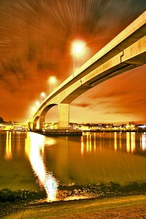
The Itchen Bridge is a bridge over the River Itchen in Southampton, Hampshire. It is a high-level hollow box girder bridge. It is located about a mile from the river mouth. The bridge spans 870 yards (800 m), is 92 feet (28 m) at its highest point and weighs 62,000 tons. The bridge connects the A3025 Portsmouth Road to Southampton. It was built to replace the former chain ferry, known as the Floating Bridge, that crossed the river at that point. The bridge's set of blue energy-saving lights can be seen from up to 5 miles (8.0 km) down Southampton Water from the bridge.

Sholing, previously Scholing, is a district on the eastern side of the city of Southampton in Southern England. It is located between the districts of Bitterne, Thornhill and Woolston.
Woolston is a suburb of Southampton, Hampshire, located on the eastern bank of the River Itchen. It is bounded by the River Itchen, Sholing, Peartree Green, Itchen and Weston.

Southampton is a city in Hampshire, South East England, 70 miles (110 km) south-west of London and 15 miles (24 km) north-west of Portsmouth. A major port, and close to the New Forest, it lies at the northernmost point of Southampton Water, at the confluence of the River Test and Itchen, with the River Hamble joining to the south. The unitary authority had a population of 253,651 at the 2011 census. A resident of Southampton is called a Sotonian.
Southampton is a city in Hampshire, England. The area has been settled since the stone age. Its history has been affected by its geographical location, on a major estuary on the English Channel coast with an unusual double high-tide, and by its proximity to Winchester and London; the ancient and modern capitals of England. Having been an important regional centre for centuries, Southampton was awarded city status by Queen Elizabeth II in 1964.
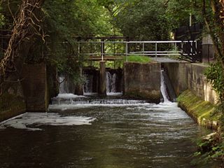
The Itchen Navigation is a 10.4-mile (16.7 km) disused canal system in Hampshire, England, that provided an important trading route from Winchester to the sea at Southampton for about 150 years. Improvements to the River Itchen were authorised by Act of Parliament in 1665, but progress was slow, and the navigation was not declared complete until 1710. It was known as a navigation because it was essentially an improved river, with the main river channel being used for some sections, and cuts with locks used to bypass the difficult sections. Its waters are fed from the River Itchen. It provided an important method of moving goods, particularly agricultural produce and coal, between the two cities and the intervening villages.

The Port of Southampton is a passenger and cargo port in the central part of the south coast of England. The modern era in the history of the Port of Southampton began when the first dock was inaugurated in 1843. The port has been owned and operated by Associated British Ports since 1982, and is the busiest cruise terminal and second largest container port in the UK.

The Northam Bridge is a road bridge across the River Itchen in Southampton, England, linking the suburbs of Northam and Bitterne Manor. The current bridge was the first major prestressed concrete road bridge to be built in the United Kingdom. The bridge carries the A3024 road as a dual carriageway, with two lanes on each carriageway.

The Woolston Floating Bridge was a cable ferry that crossed the River Itchen in England between hards at Woolston and Southampton from 23 November 1836 until 11 June 1977. It was taken out of service after the new Itchen Bridge was opened.

Itchen Ferry village was a small hamlet on the East bank of the River Itchen in Hampshire. The village took its name from the small fishing boats that were also used to ferry foot passengers across the river. An Ordnance Survey map of 1911 (NC/03/17894) shows the village to be situated in the area roughly bounded by Sea Road, Oakbank Road, the River Itchen and the railway line in modern Woolston, but also extending along Sea Road towards Peartree Green on the other side of the railway, which cut the village in half in 1866. Neighbouring streets on that same map, Defender Road, Britannia Road and Shamrock Road have a more structured layout and are clearly part of the Victorian enlargement of Woolston. The same map clearly shows the housing in Itchen Ferry village to have a more random layout. An even older map, of 1842 pins Itchen Ferry village more tightly to the area between Sea Road and Vicarage Road.

Peartree Green is an open space on high ground on the east bank of the River Itchen in Southampton. A 16/17th century building, Peartree House, still stands, though is today concealed by private housing. The house and the green take their name from a pear tree that grew near the parish church. Some of the original open space has been built on, but a large proportion remains as a recreational area. It contains a church and the remains of a boarding school. It overlooks the River Itchen to St Mary's Church in Southampton.
History of Woolston, suburb of Southampton, Hampshire.

The Port of Southampton is a major passenger and cargo port located in the central part of the south coast of England. It has been an important port since the Roman occupation of Britain nearly two thousand years ago, and has a multifaceted history. From the Middle Ages to the end of the 20th century, it was a centre for naval shipbuilding and a departure point for soldiers going to war. The port also played a role in the development of hovercraft, flying boat services, seaplanes and the Spitfire fighter plane. Before the advent of jet travel, Southampton was Britain's gateway to the world. The port also played a minor role in the history of Britain's canals.
An Itchen ferry is a type of small gaff rig cutter.
