Sobek was an ancient Egyptian deity with a complex and elastic history and nature. He is associated with the Nile crocodile or the West African crocodile and is represented either in its form or as a human with a crocodile head. Sobek was also associated with pharaonic power, fertility, and military prowess, but served additionally as a protective deity with apotropaic qualities, invoked especially for protection against the dangers presented by the Nile. Sobek has been famed for having been revered by the first female Pharao by the Nebty name Sat-Sekhem-Nebet-Tawy Sobekneferu, present both in the female Pharao's nomen, Sobek'Neferu, and her praenomen Ka'Sobek'Re.

Kom Ombo (Egyptian Arabic: كوم أمبو; Coptic: ⲈⲙⲃⲱEmbo; Ancient Greek: ὌμβοιOmboi or ὌμβοςOmbos; or Latin: Ambo and Ombi is an agricultural town in Egypt famous for the Temple of Kom Ombo. It was originally an Egyptian city called Nubt, meaning City of Gold. Nubt is also known as Nubet or Nubyt. It became a Greek settlement during the Greco-Roman Period. The town's location on the Nile, 50 kilometres north of Aswan, gave it some control over trade routes from Nubia to the Nile Valley, but its main rise to prominence came with the erection of the Temple of Kom Ombo in the 2nd century BC.

Elephantine is an island on the Nile, forming part of the city of Aswan in Upper Egypt. The archaeological sites on the island were inscribed on the UNESCO World Heritage List in 1979 along with other examples of Upper Egyptian architecture, including Abu Simbel and Philae.
A nome was a territorial division in ancient Egypt.

Wahankh Intef II was the third ruler of the Eleventh Dynasty of Egypt during the First Intermediate Period. He reigned for almost fifty years from 2112 BC to 2063 BC. His capital was located at Thebes. In his time, Egypt was split between several local dynasties. He was buried in a saff tomb at El-Tarif.
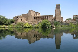
Philae is an island in the reservoir of the Aswan Low Dam, downstream of the Aswan Dam and Lake Nasser, Egypt. Philae was originally located near the expansive First Cataract of the Nile in Upper Egypt and was the site of an Egyptian temple complex. These rapids and the surrounding area have been variously flooded since the initial construction of the Aswan Low Dam in 1902. The temple complex was dismantled and moved to nearby Agilkia Island as part of the UNESCO Nubia Campaign project, protecting this and other complexes before the 1970 completion of the Aswan High Dam. The hieroglyphic reliefs of the temple complex are being studied and published by the Philae Temple Text Project of the Austrian Academy of Sciences, Vienna.

Gebel el-Silsila or Gebel Silsileh is 65 km (40 mi) north of Aswan in Upper Egypt, where the cliffs on both sides close to the narrowest point along the length of the entire Nile. The location is between Edfu in the north towards Lower Egypt and Kom Ombo in the south towards Upper Egypt. The name Kheny means "The Place of Rowing". It was used as a major quarry site on both sides of the Nile from at least the 18th Dynasty to Greco-Roman times. Silsila is famous for its New Kingdom stelai and cenotaphs.
Merankhre Mentuhotep VI was a Theban king of the Sixteenth Dynasty of Egypt based in Upper Egypt during the Second Intermediate Period. He was perhaps the 14th king of the dynasty.

El-Tarif is a necropolis on the West Bank of the Nile, at the site of ancient Thebes (Luxor), Egypt. It is located in the northwestern outskirts of Luxor and southeast of the Valley of the Kings, opposite Karnak, just to the southwest of the modern village of At-Tarif. It is the oldest of West Thebes' necropolises. It is a small mortuary temple, and the farthest north of the Tombs of the Nobles, and contains tombs of the late First Intermediate Period, Second Intermediate Period and early Middle Kingdom. Old Kingdom mastabas are possibly attributed to local rulers of the Fourth or Fifth Dynasty. Eleventh Dynasty tombs of local rulers have also been noted in the form of a series of rock-cut tombs dated to 2061-2010 B.C.E, the largest of which are Intef I to Intef III, who were kings of this dynasty.
Akoris ; Egyptian: Mer-nefer(et), Per-Imen-mat-khent(j), or Dehenet is the Greek name for the modern Egyptian village of Ṭihnā al-Ǧabal, located about 12 km north of Al Minya. The ancient site is situated in the southeast of the modern village.

Neferkauhor Khuwihapi was an ancient Egyptian pharaoh of the Eighth Dynasty during the early First Intermediate Period, at a time when Egypt was possibly divided between several polities. Neferkauhor was the sixteenth and penultimate king of the Eighth Dynasty and as such would have ruled over the Memphite region. Neferkauhor reigned for little over 2 years and is one of the best attested kings of this period with eight of his decrees surviving in fragmentary condition to this day.

The Faiyum Oasis is a depression or basin in the desert immediately to the west of the Nile south of Cairo in Egypt. The extent of the basin area is estimated at between 1,270 km2 (490 mi2) and 1,700 km2 (656 mi2). The basin floor comprises fields watered by a channel of the Nile, the Bahr Yussef, as it drains into a desert hollow to the west of the Nile Valley. The Bahr Yussef veers west through a narrow neck of land north of Ihnasya, between the archaeological sites of El Lahun and Gurob near Hawara; it then branches out, providing rich agricultural land in the Faiyum basin, draining into the large saltwater Lake Moeris. The lake was freshwater in prehistory but is today a saltwater lake. It is a source for tilapia and other fish for the local area.

Gebelein was a town in Egypt. It is located on the Nile, about 40 km south of Thebes, in the New Valley Governorate.
Ta-Seti was the first nome of Upper Egypt, one of 42 nomoi in Ancient Egypt. Ta-Seti marked the border area towards Nubia, and the name was also used to refer to Nubia itself.

Shemay was an ancient Egyptian official and later vizier toward the end of the 8th Dynasty during the First Intermediate Period, mainly known for being the beneficiary of most of the Coptos Decrees. His career has been interpreted as a glaring sign of the extreme weakness of the central power, forced to bestow great privileges to maintain the loyalty of powerful local governors. Shemay is buried in a mudbrick mastaba just south of Coptos.
Herwer was an ancient Egyptian town in the 16th nome in Upper Egypt. It is mentioned in several ancient inscriptions dating from the Old, Middle and New Kingdom. The main deities of the place were Khnum and Heqet, both several times called lord or lady of Herwer. Perhaps in the Middle Kingdom, the place became capital of the 16th Upper Egyptian nome. The local governor Amenemhat of that nome was indeed overseer of the priests of Khnum of Herwer. The place is often mentioned in the tombs of Beni Hasan.

The Oryx nome was one of the 42 nomoi in ancient Egypt. The oryx nome was the 16th nome of Upper Egypt, and was named after the Scimitar oryx. It was located, approximately, in the territories surrounding the modern city of Minya in Middle Egypt.
Hypselis or Hypsela, known to the ancient Egyptians as Shashotep, is an ancient Egyptian city and Roman bishopric, which was located near the modern town of Shutb in the Asyut Governorate.
Sumenu or Smenu was an ancient Egyptian town located in Upper Egypt. It housed the most prominent early-Middle Kingdom sanctuary of the crocodile-god Sobek.
