Ifẹ̀ is an ancient Yoruba city in south-western Nigeria, recent in-depth archeologically estimates suggest Ife's founding to be between the 10th century BC and 6th century BC and is widely agreed upon by historians to be the oldest amongst the classical and post-classical Yoruba city-states. The city is located in present-day Osun State. Ifẹ̀ is about 218 kilometers northeast of Lagos with a population of over 500,000 people, which is the highest in Osun State according to population census of 2006.
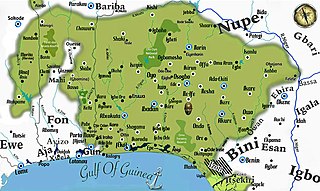
Yorubaland is the homeland and cultural region of the Yoruba people in West Africa. It spans the modern-day countries of Nigeria, Togo and Benin, and covers a total land area of 142,114 km2 (54,871 sq mi). Of this land area, 106,016 km2 (74.6%) lies within Nigeria, 18.9% in Benin, and the remaining 6.5% is in Togo. Prior to European colonization, a portion of this area was known as Yoruba country. The geo-cultural space contains an estimated 55 million people, the majority of this population being ethnic Yoruba.
Ketu is the name of a Yoruba subgroup, historical kingdom and region straddling parts of what is now southeastern Republic of Benin and parts of southwest Nigeria. The chief town and traditional capital of the area was the town of Kétou (Kétu), which is considered to be one of the oldest capitals of the Yoruba-speaking people, tracing its establishment to a settlement founded by a descendant of Oduduwa called Sopasan or Soipasan. The Oba of the town were traditionally styled "Alákétu", and are related directly to Ile-Ife in present-day Nigeria. Other towns that were historically part of the Kétu Kingdom are;

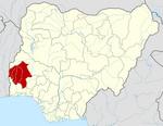
Osun State, occasionally known as the State of Osun by the state government, is a state in southwestern Nigeria; bounded to the east by Ekiti and Ondo states for 84 km and for 78 km respectively, to the north by Kwara State for 73 km, to the south by Ogun State for 84 km and to the west by Oyo State, mostly across the River Osun. Named for the River Osun—a vital river which flows through the state—the state was formed from the southeast of Oyo State on 27 August 1991 and has its capital as the city of Osogbo.

Oyo State is an inland state in southwestern Nigeria. Its capital is Ibadan, the third most populous city in the country and formerly the second most populous city in Africa. Oyo State is bordered to the north by Kwara State for 337 km, to the east by Osun State for 187 km, partly across the River Osun, and to the south by Ogun State, and to the west by the Republic of Benin for 98 km. With a projected population of 7,976,100 in 2022, Oyo State is the sixth most populous in the Nigeria.

Iseyin is a city located in Oyo, Nigeria. It is approximately 100 km (62 mi) north of Ibadan. The city was estimated to have a population of 236,000, according to United Nations 2005 estimate, which increased to 362,990 in 2011, and has a total land mass of 2,341 km2 (904 sq mi). Its inhabitants are mostly of Yoruba origin and its ruler is the Aseyin of Iseyin, with the current being Oba Sefiu Oyebola Adeyeri III, Ajirotutu I.
Bida is a Local Government Area in Niger State, Nigeria and a city on the A124 highway which occupies most of the area.
Offa is a city in Kwara State of Nigeria, with a population of about 166,112 inhabitants. The town is noted for its weaving and dyeing trade, using vegetable dyes made from locally grown indigo and other plants. Offa is well known for the cultivation of sweet potatoes and maize which also formed part of the favourite staple foods for the indigenes in the town. Cattle, goats and sheep are also raised there. The main religions practiced in the town are Islam, Christianity and traditional religions.

Egbeda is a Local Government Area in the senatorial district of Oyo central in Ibadan less city of Oyo State, Nigeria. Its headquarters are in the town of Egbeda. Egbeda local government was carved out Lagelu Local government in 1989. The postal code of the area is 200109
Ori Ire is a Local Government Area in Oyo State, Nigeria. Its headquarters are in the town of Ikoyi.

Kajola is a Local Government Area in Oyo State, Nigeria. Its headquarters are in the town of Okeho.
Atiba is a Local Government Area in Oyo State, Nigeria. Its headquarters is in the town of Offa Meta.
Atisbo is a Local Government Area in Okeogun, Oyo State, Nigeria. Its headquarters are in the town of Tede. Atisbo local Government which is erroneously spelt as ATIGBO by many online pages was created by former Head of State Late Gen. Sanni Abacha in 1996.
Shinkafi is a Local Government Area in Zamfara State of Nigeria. Its headquarters is in the town of Shinkafi an area of about 674mk2 and population of 135,649. It shares boundaries with Isa Local Government Area and Niger Republic from the north, Zurmi Local Government Area to the South and South-East, Maradun Local Government Area and Raba Local Government Area by the west. Distance from the State Capital, Gusau is approximately 116 km.
Ife South is a Local Government Area in Osun State, Nigeria. Its headquarters are in the town of Ifetedo at 7°11′00″N4°42′00″E.
Ileogbo is the headquarters of Aiyedire Local Government in Osun State, Nigeria. It is situated midway between Ibadan and Osogbo, the capitals of Oyo and Osun State. Ibadan is about 44 km to the south of Ileogbo while Osogbo is about 42 km to its north, Oyo 40 km to its west, while Gbongan and Ife are located to the east of the town.
Iwoye-Ketu is a town primarily located in Imeko Afon, Ogun State in southwest Nigeria with its western portion in Benin. The community shares a border with the Iwajowa local government area of Oyo State on the north. It is renowned for its production of cotton.
The Òǹkò, otherwise known as Òkè Ògùn people, are a Yoruba people group inhabiting the areas drained by the upper Ogun river in Northwestern Oyo state in Nigeria. They were historically a part of the once expansive Oyo empire, but are distinct from the Oyo proper.

Okeho is a town located in Kajola Oyo State South West Nigeria. It is the headquarters of Kajola Local Government.