Ixopo

Last updated

Ixopo
Stuartstown
SAR Class NG G11 NG55 (2-6-0+0-6-2).JPG
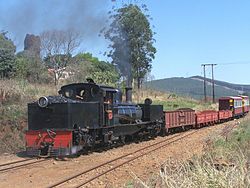
SAR Class NG G11 no. NG55 arriving at Ixopo station
South Africa KwaZulu-Natal location map.svg
Red pog.svg
Ixopo
South Africa adm location map.svg
Red pog.svg
Ixopo
Coordinates: 30°09′26″S30°03′53″E / 30.15722°S 30.06472°E / -30.15722; 30.06472 Coordinates: 30°09′26″S30°03′53″E / 30.15722°S 30.06472°E / -30.15722; 30.06472
Country South Africa
Province KwaZulu-Natal
District Harry Gwala
Municipality Ubuhlebezwe
Area
[1]
  Total10.85 km2 (4.19 sq mi)
Population
 (2011) [1]
  Total12,461
  Density1,100/km2 (3,000/sq mi)
Racial makeup (2011)
[1]
   Black African 90.6%
   Coloured 5.6%
   Indian/Asian 1.9%
   White 1.4%
  Other0.5%
First languages (2011)
[1]
   Zulu 74.8%
   English 10.6%
   Xhosa 7.6%
   Sotho 2.2%
  Other4.8%
Time zone UTC+2 (SAST)
Postal code (street)
3276
PO box
3276
Area code 039

Ixopo, also known as Stuartstown, is a town situated on a tributary of the Mkhomazi River along the R56 highway in the midlands of KwaZulu-Natal, South Africa.

Contents

Background

The town was laid out in 1878 and named after M Stuart, Resident Magistrate of the surrounding district, who was killed at the Battle of Ingogo in 1881. [2] [3] :256 Its name is derived from the Zulu onomatopoeic word, eXobo, describing the sound made as cattle squelch through mud. [3] :256 The 'x', in Zulu, is pronounced as a lateral click.

The town is most famously described by Alan Paton in the opening lines of Cry, The Beloved Country: "There is a lovely road which runs from Ixopo into the hills. These hills are grass covered and rolling, and they are lovely beyond any singing of it." [3] :256

Until the mid-1980s, Ixopo was served by a railway station on the 610 mm (2 ft 0 in) narrow gauge Umzinto - Donnybrook narrow gauge railway. [3] :256

Notable people

Related Research Articles

<span class="mw-page-title-main">KwaZulu-Natal</span> Province in South Africa

KwaZulu-Natal is a province of South Africa that was created in 1994 when the Zulu bantustan of KwaZulu and Natal Province were merged. It is located in the southeast of the country, with a long shoreline on the Indian Ocean and sharing borders with three other provinces and the countries of Mozambique, Eswatini and Lesotho. Its capital is Pietermaritzburg, and its largest city is Durban. It is the second-most populous province in South Africa, with slightly fewer residents than Gauteng.

<span class="mw-page-title-main">Port Shepstone</span> Seaside town in KwaZulu-Natal, South Africa

Port Shepstone is a large town situated on the mouth of the Mzimkhulu River, the largest river on the KwaZulu-Natal South Coast of South Africa. It is located halfway between Hibberdene and Margate and is positioned 120 km south of Durban. It is the administrative, educational and commercial centre for southern Natal.

Harding is a town situated in the Mzimkulwana River valley, Ugu District Municipality of KwaZulu-Natal, South Africa

Umzinto is a town, located in the South Coast of KwaZulu-Natal, South Africa and falls under the uMdoni Local Municipality. It was a sugarcane growing area and the town was set up as the centre for a sugar mill.

The following lists events that happened during 1914 in South Africa.

The following lists events that happened during 1902 in South Africa.

The following lists events that happened during 1879 in South Africa.

The following lists events that happened during 1906 in South Africa.

<span class="mw-page-title-main">R56 (South Africa)</span> Road in South Africa

The R56 is a provincial route in South Africa that connects Middelburg with Pietermaritzburg via Molteno, Maclear and Kokstad. It is co-signed with the N2 between Kokstad and Stafford's Post for 39 kilometres.

<span class="mw-page-title-main">3 ft 6 in gauge railways</span> Railway track gauge (1067 mm)

Railways with a track gauge of 3 ft 6 in / 1,067 mm were first constructed as horse-drawn wagonways. The first intercity passenger railway to use 3 ft 6 in was constructed in Norway by Carl Abraham Pihl. From the mid-nineteenth century, the 3 ft 6 in gauge became widespread in the British Empire. In Africa it became known as the Cape gauge as it was adopted as the standard gauge for the Cape Government Railways in 1873, although it had already been established in Australia and New Zealand before that. It was adopted as a standard in New Zealand, South Africa, Indonesia, Japan, the Philippines, Taiwan, and Queensland in Australia.

<span class="mw-page-title-main">Bulwer, KwaZulu-Natal</span> Place in KwaZulu-Natal, South Africa

Bulwer is a small town in the KwaZulu-Natal's Midlands region, South Africa. It is situated on the R617 regional road between the towns of Boston and Underberg and around 50 minutes north-west of the town of Ixopo on the R56. The village is nestled in the shadow of the Amahwaqa mountain.

<span class="mw-page-title-main">South African Class 91-000</span> South African diesel locomotive class

The South African Railways Class 91-000 of 1973 was a narrow-gauge diesel–electric locomotive.

Kelso is located in the uMdoni Coast region of South Africa facing the Indian Ocean. Kelso is located 65 kilometers south of Durban, the largest city in KwaZulu-Natal.

<span class="mw-page-title-main">South African Class NG G11 2-6-0+0-6-2</span>

The South African Railways Class NG G11 2-6-0+0-6-2 of 1919 was a narrow gauge steam locomotive.

<span class="mw-page-title-main">South African Class NG3 4-6-2T</span>

The South African Railways Class NG3 4-6-2T of 1907 was a narrow-gauge steam locomotive from the pre-Union era in the Colony of Natal.

<span class="mw-page-title-main">South African Class NG G12 2-6-2+2-6-2</span>

The South African Railways Class NG G12 2-6-2+2-6-2 of 1927 was an articulated narrow-gauge steam locomotive.

<span class="mw-page-title-main">Two-foot-gauge railways in South Africa</span>

In the early 1900s, 2 ft narrow-gauge railway lines started playing a significant role in South Africa. They facilitated the transport of various agricultural and mineral produce from locations hardly accessible by road. They therefore enabled many communities to become prosperous.

<span class="mw-page-title-main">Umzinto–Donnybrook narrow-gauge railway</span>

The Umzinto–Donnybrook narrow-gauge railway is a closed 2 ft narrow-gauge railway line in South Africa. It runs from Umzinto to Donnybrook, passing through Highflats and Ixopo, with a branch from Ixopo to Madonela. The line was built in 1908 and was 93 miles (150 km) in length.

<span class="mw-page-title-main">Paton's Country Narrow Gauge Railway</span>

The Paton's Country Narrow Gauge Railway (PCNGR) is a 2 ft narrow-gauge heritage railway in KwaZulu-Natal, South Africa.

Umzimkhulu is a town in Harry Gwala District Municipality in the KwaZulu-Natal province of South Africa.

References

  1. 1 2 3 4 "Main Place Ixopo". Census 2011.
  2. "Dictionary of Southern African Place Names (Public Domain)". Human Science Research Council. p. 421.
  3. 1 2 3 4 Conolly, Denis (1975). The Tourist in South Africa. Travel-Guide (PTY) LTD. ASIN   B0000E7XZN.

3. R56 information Route 56 - Ixopo