Related Research Articles
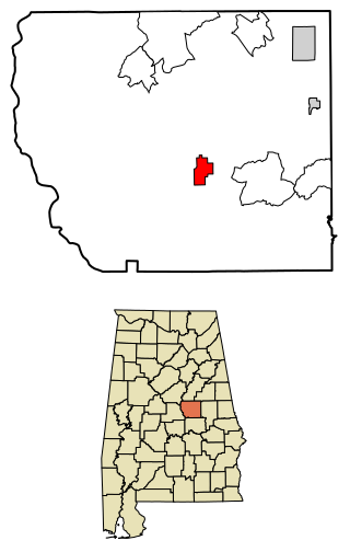
Rockford is a town in Coosa County, Alabama, United States. At the 2020 census, the population was 349. The town is the county seat of Coosa County and is part of the Talladega-Sylacauga Micropolitan Statistical Area.

Walden is the Statutory Town that is the county seat, the most populous community, and the only incorporated municipality in Jackson County, Colorado, United States. It is situated in the center of a large open valley called North Park. People from Walden and the surrounding area refer to themselves as "North Parkers". The town population was 606 at the 2020 census. The town sits at an elevation of 8,099 feet. It was established in 1889 and was incorporated 2 December 1890. Mark A. Walden, an early postmaster, gave the community his name.
Dillon is a city in and the county seat of Beaverhead County, Montana, United States. The population was 3,880 at the 2020 census. The city was named for Sidney Dillon (1812–1892), president of Union Pacific Railroad.

Wisdom is a small town in Beaverhead County, Montana, United States. The population was 98 at the 2010 census. The ZIP Code of the area is 59761. The town includes three tourist lodgings, service station, grocery, school (K-8), post office and a Forest Service office.
White Sulphur Springs is a city in and the county seat of Meagher County, Montana, United States. The population was 955 at the 2020 census.

Seeley Lake is a census-designated place (CDP) in Missoula County, Montana, United States. It is part of the 'Missoula, Montana Metropolitan Statistical Area'. The town sits beside the 1,031.5 acres lake Seeley Lake. The population was 1,659 at the 2010 census, an increase from its population of 1,436 in 2000.

Three Rivers is a city in St. Joseph County, Michigan. The population was 7,973 at the time of the 2020 census.

Jackson is a town in Northampton County, North Carolina, United States. The population was 513 at the 2010 census. It is the county seat of Northampton County.

Greater Boston is the metropolitan region of New England encompassing the municipality of Boston, the capital of the U.S. state of Massachusetts and the most populous city in New England, and its surrounding areas. The region forms the northern arc of the Northeast megalopolis, making Greater Boston both a metropolitan statistical area (MSA) and a combined statistical area (CSA). The most stringent definition of the region consists of most of the eastern third of mainland Massachusetts, excluding the Merrimack Valley and South Coast; while the most expansive definition includes these plus Cape Cod, Central Massachusetts, Rhode Island, southeastern New Hampshire, and Windham County, Connecticut.

Hiko is a small, agrarian community in the Tonopah Basin on State Route 318 in Lincoln County, Nevada, United States. It is a census-designated place, with a population of 119 at the 2010 census.
Biddle is a village in southeastern Powder River County, Montana, United States, near the Little Powder River. It lies along Highway 59, south of the town of Broadus, the county seat of Powder River County.
Wise River is an unincorporated community in northern Beaverhead County, Montana, United States. State Highway 43 runs through the town.
Condon is an unincorporated community and census-designated place in Missoula County, Montana, United States. Located along the Swan River and Montana Highway 83, Condon is situated between the Swan Range to the east and the Mission Mountains to the west, providing ready access to the Bob Marshall Wilderness and Mission Mountains Wilderness, respectively. Its population was 343 as of the 2010 census.

Dell is a census-designated place in Beaverhead County, Montana, United States. The settlement is located in a valley beside the Red Rock River.
Glen is an census-designated place in Beaverhead County, Montana, United States. Glen has a post office with a ZIP code of 59732. Glen lies on U.S. Route 91, south of Melrose and north of Dillon. The Big Hole River runs past the east side of the town.
Lakeview is an unincorporated community in Beaverhead County, Montana, United States. Lakeview lies along Southside Centennial Road, approximately halfway between Lima to the west and West Yellowstone to the east.
Polaris is an unincorporated community in Beaverhead County, Montana, United States. Polaris has a post office with a ZIP code 59746. Polaris lies in the Grasshopper Valley, along the Pioneer Mountain Scenic Byway, southeast of Wisdom. This community takes its name from the Polaris Mine, which operated as a silver mine from 1885 until 1922.

Roy is a census-designated place (CDP) in Fergus County, Montana, United States.
Faywood is a census-designated place in Grant County, New Mexico, United States. Its population was 33 as of the 2010 census. Faywood has a post office with ZIP code 88034. It is located 3 miles (4.8 km) north of US 180 on NM 61.
Swan Lake is a census-designated place and unincorporated community in Lake County, Montana, United States. Its population was 113 as of the 2010 census.
References
- ↑ "ArcGIS REST Services Directory". United States Census Bureau. Retrieved September 18, 2022.
- 1 2 U.S. Geological Survey Geographic Names Information System: Jackson, Montana
- ↑ Zip Code Lookup
- ↑ "Explore Census Data". data.census.gov. Retrieved January 29, 2022.
- ↑ "Jackson". Montana Place Names Companion. Montana Historical Society. Retrieved April 5, 2021.
- ↑ "xmACIS2". National Oceanic and Atmospheric Administration. Retrieved July 9, 2023.
- ↑ "U.S. Climate Normals Quick Access". National Oceanic and Atmospheric Administration. Archived from the original on July 9, 2023. Retrieved July 9, 2023.
- ↑ "Census of Population and Housing". Census.gov. Retrieved June 4, 2016.
- ↑ "Schools Beaverhead County". Beaverhead County. Retrieved April 14, 2021.
Municipalities and communities of Beaverhead County, Montana, United States | ||
|---|---|---|
| City |  | |
| Town | ||
| CDPs | ||
| Other communities | ||
| Ghost towns | ||
45°22′05″N113°24′32″W / 45.36806°N 113.40889°W
| | This Beaverhead County, Montana state location article is a stub. You can help Wikipedia by expanding it. |