Jackson Center, Ohio

Last updated

Jackson Center, Ohio
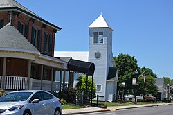
West Pike, Jackson Center.jpg
OHMap-doton-Jackson Center.png
Location of Jackson Center, Ohio
Map of Shelby County Ohio Highlighting Jackson Center Village.png
Location of Jackson Center in Shelby County
Coordinates: 40°26′19″N84°02′28″W / 40.43861°N 84.04111°W / 40.43861; -84.04111
Country United States
State Ohio
County Shelby
Government
   Mayor Scott Klopfenstein
Area
[1]
  Total1.73 sq mi (4.48 km2)
  Land1.72 sq mi (4.46 km2)
  Water0.01 sq mi (0.02 km2)
Elevation
[2]
1,027 ft (313 m)
Population
 (2020)
  Total1,441
  Density837.30/sq mi (323.27/km2)
Time zone UTC-5 (Eastern (EST))
  Summer (DST) UTC-4 (EDT)
ZIP code
45334
Area code(s) 937, 326
FIPS code 39-38220 [3]
GNIS feature ID2398286 [2]
Website http://www.jacksoncenter.com/

Jackson Center is a village in Shelby County, Ohio, United States. The population was 1,441 at the 2020 census.

Contents

Jackson Center has been the home of the popular Airstream travel trailers and motor homes since 1952.

Jackson Center is accessible from Interstate 75 at Exit 102, north of the Shelby County seat of Sidney. State Route 274 links I-75 to Jackson Center (the exit is signed "Jackson Center/New Bremen").

History

Jackson Center was platted in 1835. [4] A post office called Jackson Center has been in operation since 1858. [5]

Geography

According to the United States Census Bureau, the village has a total area of 1.69 square miles (4.38 km2), of which 1.68 square miles (4.35 km2) is land and 0.01 square miles (0.03 km2) is water. [6]

Demographics

Historical population
CensusPop.Note
1870 60
1900 644
1910 6856.4%
1920 573−16.4%
1930 526−8.2%
1940 5667.6%
1950 69823.3%
1960 98040.4%
1970 1,11914.2%
1980 1,31017.1%
1990 1,3986.7%
2000 1,369−2.1%
2010 1,4626.8%
2020 1,441−1.4%
U.S. Decennial Census [7]

2000 census

As of the census [8] of 2000, there were 1,369 people, 541 households, and 394 families living in the village. The population density was 1,088.9 inhabitants per square mile (420.4/km2). There were 584 housing units at an average density of 464.5 per square mile (179.3/km2). The racial makeup of the village was 99.12% White, 0.51% African American, 0.22% Native American, 0.15% from other races. Hispanic or Latino of any race were 0.44% of the population.

There were 541 households, out of which 36.8% had children under the age of 18 living with them, 58.8% were married couples living together, 10.2% had a female householder with no husband present, and 27.0% were non-families. 23.7% of all households were made up of individuals, and 12.6% had someone living alone who was 65 years of age or older. The average household size was 2.53 and the average family size was 2.97.

In the village, the population was spread out, with 29.2% under the age of 18, 8.8% from 18 to 24, 28.3% from 25 to 44, 20.2% from 45 to 64, and 13.4% who were 65 years of age or older. The median age was 33 years. For every 100 females there were 94.5 males. For every 100 females age 18 and over, there were 89.3 males.

The median income for a household in the village was $40,650, and the median income for a family was $47,240. Males had a median income of $35,313 versus $23,654 for females. The per capita income for the village was $17,755. About 6.2% of families and 7.6% of the population were below the poverty line, including 12.7% of those under age 18 and 6.7% of those age 65 or over.

2010 census

As of the census [8] of 2010, there were 1,462 people, 576 households, and 404 families living in the village. The population density was 870.2 inhabitants per square mile (336.0/km2). There were 644 housing units at an average density of 383.3 per square mile (148.0/km2). The racial makeup of the village was 98.1% White, 0.1% Asian, 0.6% from other races, and 1.2% from two or more races. Hispanic or Latino of any race were 1.7% of the population.

There were 576 households, of which 36.3% had children under the age of 18 living with them, 53.0% were married couples living together, 10.2% had a female householder with no husband present, 6.9% had a male householder with no wife present, and 29.9% were non-families. 26.9% of all households were made up of individuals, and 10.4% had someone living alone who was 65 years of age or older. The average household size was 2.54 and the average family size was 3.05.

The median age in the village was 35.7 years. 29.7% of residents were under the age of 18; 5.9% were between the ages of 18 and 24; 27.9% were from 25 to 44; 23% were from 45 to 64; and 13.6% were 65 years of age or older. The gender makeup of the village was 49.9% male and 50.1% female.
Education

Jackson Center Local School District operates one large K-12 school building which includes the Jackson Center High School. [9]

Jackson Center has a public library, a branch of Shelby County Libraries. [10]

Arts and culture

Jackson Center is the location of the Elder Theatre, the last indoor movie theater serving Shelby County. (The Sidney Theater in Sidney, Ohio is now a local live performance venue.) The Elder, in business since 1942, held a fundraiser to convert to digital projection equipment as 35mm film is being phased out. A fundraiser took place starting on May 20, 2013, and met the $28,000 goal before midnight on July 2, 2013.[ citation needed ]

Related Research Articles

<span class="mw-page-title-main">Shelby County, Ohio</span> County in Ohio, United States

Shelby County is a county in the western portion of the U.S. state of Ohio. As of the 2020 United States Census, the population was 48,230. Its county seat is Sidney. Its name honors Isaac Shelby, first governor of Kentucky.

<span class="mw-page-title-main">Richland County, Ohio</span> County in Ohio, United States

Richland County is a county located in the U.S. state of Ohio. As of the 2020 census, the population was 124,936. Its county seat is Mansfield. The county was created in 1808 and later organized in 1813. It is named for the fertile soil found there. Richland County is included in the Mansfield, OH Metropolitan Statistical Area as well as the Mansfield-Ashland-Bucyrus, OH Combined Statistical Area. The county is one of the six Metropolitan Statistical Areas that make up Northeast Ohio.

<span class="mw-page-title-main">Shelby, Oceana County, Michigan</span> Village in Michigan, United States

Shelby is a village in Oceana County in the U.S. state of Michigan. The population was 2,065 at the 2010 census.

<span class="mw-page-title-main">Jacksonville, Ohio</span> Village in Ohio, United States

Jacksonville is a village in Athens County, Ohio, United States. The population was 400 at the 2020 census.

<span class="mw-page-title-main">Minster, Ohio</span> Village in Ohio, United States

Minster is a village in Auglaize and Shelby counties, in the U.S. state of Ohio. The population was 3,046 at the 2020 census. It is included in the Wapakoneta, Ohio Micropolitan Statistical Area. It is adjacent to the village of New Bremen to the north.

<span class="mw-page-title-main">Jacksonburg, Ohio</span> Village in Ohio, United States

Jacksonburg is a small village in Butler County, Ohio, United States. The population was 55 at the 2020 census.

<span class="mw-page-title-main">New Weston, Ohio</span> Village in Ohio, United States

New Weston is a village in Darke County, Ohio, United States. The population was 124 at the 2020 census.

<span class="mw-page-title-main">Rossburg, Ohio</span> Village in Ohio, United States

Rossburg is a village in Darke County, Ohio, United States. The population was 159 at the 2020 census.

<span class="mw-page-title-main">Centerville, Gallia County, Ohio</span> Village in Ohio, United States

Centerville, also known as Thurman, is a city in western Gallia County, Ohio, United States. The city lies adjacent to the Gallia - Jackson county line. It is located adjacent to U.S. Route 35 at the eastern terminus of State Route 279.

<span class="mw-page-title-main">Rawson, Ohio</span> Village in Ohio, United States

Rawson is a village in Hancock County, Ohio, United States. The population was 567 at the 2020 census.

<span class="mw-page-title-main">Liberty Center, Ohio</span> Village in Ohio, United States

Liberty Center is a village in Henry County, Ohio, United States. The population was 1,108 at the 2020 census.

<span class="mw-page-title-main">Coalton, Ohio</span> Village in Ohio, United States

Coalton is a village in Jackson County, Ohio, United States. The population was 445 at the 2020 census.

<span class="mw-page-title-main">Westfield Center, Ohio</span> Village in Ohio, United States

Westfield Center is a village in Medina County, Ohio, United States. The population was 1,184 at the 2020 census. It is the home of Westfield Insurance, the largest employer in Medina County.

<span class="mw-page-title-main">Farmersville, Ohio</span> Village in Ohio, United States

Farmersville is a village in Jackson Township, Montgomery County, Ohio, United States. The population was 975 at the 2020 census. It is part of the Dayton Metropolitan Statistical Area.

<span class="mw-page-title-main">Ottawa, Ohio</span> Village in Ohio, US

Ottawa is a village and the county seat of Putnam County, Ohio, United States. It is located about 51 miles (82 km) southwest of Toledo. The population is 4,456 as of the 2020 census.

<span class="mw-page-title-main">Shelby, Ohio</span> City in Ohio, United States

Shelby is a city in Richland County in the U.S. state of Ohio, northwest of the city of Mansfield. It is part of the Mansfield, Ohio Metropolitan Statistical Area. The population was 9,282 as of the 2020 census.

<span class="mw-page-title-main">Anna, Ohio</span> Village in Ohio, United States

Anna is a village in Shelby County, Ohio, United States. The population was 1,470 at the 2020 census.

<span class="mw-page-title-main">Botkins, Ohio</span> Village in Ohio, United States

Botkins is a village in Shelby County, Ohio, United States. The population was 1,155 at the 2020 census.

<span class="mw-page-title-main">Kettlersville, Ohio</span> Village in Ohio, United States

Kettlersville is a village in Shelby County, Ohio, United States. The population was 164 at the 2020 census.

<span class="mw-page-title-main">Port Jefferson, Ohio</span> Village in Ohio, United States

Port Jefferson is a village in Salem Township, Shelby County, Ohio, United States. The population was 308 at the 2020 census.

References

  1. "ArcGIS REST Services Directory". United States Census Bureau. Retrieved September 20, 2022.
  2. 1 2 U.S. Geological Survey Geographic Names Information System: Jackson Center, Ohio
  3. "U.S. Census website". United States Census Bureau . Retrieved January 31, 2008.
  4. Hitchcock, Almon Baldwin Carrington (1913). History of Shelby County, Ohio, and representative citizens. p. 357.
  5. "Shelby County". Jim Forte Postal History. Retrieved December 24, 2015.
  6. "US Gazetteer files 2010". United States Census Bureau. Archived from the original on January 12, 2012. Retrieved January 6, 2013.
  7. "Census of Population and Housing". Census.gov. Retrieved June 4, 2015.
  8. 1 2 "U.S. Census website". United States Census Bureau . Retrieved January 6, 2013.
  9. "Information About Jackson Center Local Schools". Jackson Center Local Schools. Retrieved March 3, 2018.
  10. "Locations". Shelby County Libraries. Retrieved March 3, 2018.