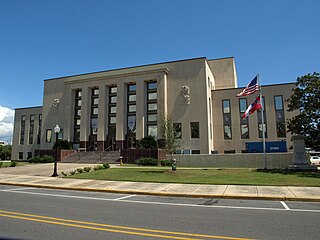
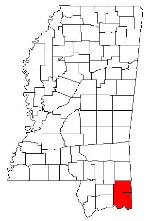
Jackson County is a county located in the U.S. state of Mississippi. As of the 2010 census, the population was 139,668, making it the fifth-most populous county in Mississippi. Its county seat is Pascagoula. The county was named for Andrew Jackson, general in the United States Army and afterward President of the United States.

Big Point is an unincorporated community and census-designated place (CDP) in Jackson County, Mississippi, United States. It is part of the Pascagoula, Mississippi Metropolitan Statistical Area. Per the 2020 Census, the population was 618.

Escatawpa is an unincorporated community and census-designated place (CDP) in Jackson County, Mississippi, United States. It is part of the Pascagoula Metropolitan Statistical Area. The population was 3,254 at the 2020 census.
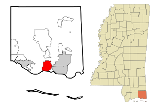
Gautier is a city in Jackson County, Mississippi, United States, along the Gulf of Mexico west of Pascagoula. It is part of the Pascagoula Metropolitan Statistical Area. The population was 18,572 at the 2010 census, up from 11,681 at the 2000 census. In 2002, Gautier had annexed land more than doubling its area.

Gulf Hills is an unincorporated community and census-designated place (CDP) in Jackson County, Mississippi, United States. It is part of the Pascagoula Metropolitan Statistical Area. The population was 7,144 at the 2010 census, up from 5,900 at the 2000 census.

Hurley is an unincorporated community and census-designated place (CDP) in Jackson County, Mississippi, United States. It is part of the Pascagoula Metropolitan Statistical Area. The population was 1,551 at the 2010 census, up from 985 at the 2000 census.

St. Martin is a census-designated place (CDP) in Jackson County, Mississippi, United States. It is part of the Pascagoula Metropolitan Statistical Area. The population was 7,730 at the 2010 census, up from 6,676 at the 2000 census.

Vancleave is an unincorporated community and census-designated place (CDP) in Jackson County, Mississippi, United States. It is part of the Pascagoula Metropolitan Statistical Area. The population was 5,886 at the 2010 census, up from 4,910 at the 2000 census.

Wade is an unincorporated community and census-designated place (CDP) in Jackson County, Mississippi, United States. It is part of the Pascagoula Metropolitan Statistical Area. The population was 1,074 at the 2010 census, up from 491 at the 2000 census.

The Pascagoula River is a river, about 80 miles (130 km) long, in southeastern Mississippi in the United States. The river drains an area of about 8,800 square miles (23,000 km²) and flows into Mississippi Sound of the Gulf of Mexico. The Pascagoula River Basin is managed by the Pat Harrison Waterway District.

Mississippi Highway 63 is an state highway in southeastern Mississippi that runs north–south for approximately 105 miles (169 km). It serves Jackson County, George County, Greene County, and Wayne County.

The Gulfport-Biloxi Metropolitan Statistical Area is a metropolitan statistical area (MSA) in the Mississippi Gulf Coast region that includes four counties – Hancock, Harrison, Jackson and Stone. The principal cities are Gulfport and Biloxi. The 2010 census placed the Gulfport-Biloxi MSA population at 388,488, though as of 2019, it was estimated to have increased to 417,665. The area was significantly impacted by Hurricane Katrina on August 29, 2005, and prior to the hurricane, had experienced steady to moderate population growth. However, growth has since rebounded, with the population steadily increasing every year throughout the 2010s.
The Pascagoula Metropolitan Statistical Area is a metropolitan area in the southeastern corner of Mississippi that covers two counties - Jackson and George. As of the 2000 census, the MSA had a population of 150,564. The area was significantly impacted by Hurricane Katrina in 2005. A July 1, 2009 estimate placed the population at 155,603. Prior to the hurricane, the area had experienced steady population growth. It is also part of the larger Gulfport-Biloxi-Pascagoula Combined Statistical Area.

The Gulfport–Biloxi–Pascagoula Combined Statistical Area is made up of five counties in the Mississippi Gulf Coast region. The statistical area consists of the Gulfport–Biloxi Metropolitan Statistical Area and the Pascagoula Metropolitan Statistical Area. The 2010 census placed the CSA population at 411,066, and as of 2019, is estimated to be 442,165. The area was significantly impacted by Hurricane Katrina on August 29, 2005, although population growth has steadily rebounded in recent years.
The Jackson County School District (JCSD) is a public school district based in Jackson County, Mississippi (USA).

Interstate 10 (I-10), a major east–west Interstate Highway in the southern areas of the United States, has a section of about 77 miles (124 km) in Mississippi.

Mississippi Highway 613 is a 45.7-mile-long (73.5 km) north-south state highway in the eastern Mississippi Gulf Coast region of southeastern Mississippi. It connects the town of Lucedale with the city of Pascagoula.

Mississippi Highway 614 is a 10.3-mile-long (16.6 km) east–west state highway in northeastern Jackson County, Mississippi. It connects the communities of Wade and Hurley with the Alabama state line and the city of Mobile.

Walter Michael Ezell is an American law enforcement officer and politician. He is the member for Mississippi's 4th congressional district in the United States House of Representatives since 2023.

