Jacksons is a settlement in British Columbia. According to a Canadian government resource, Jacksons is a scattered settlement of fifty or fewer individuals. [1]
Jacksons is a settlement in British Columbia. According to a Canadian government resource, Jacksons is a scattered settlement of fifty or fewer individuals. [1]

British Columbia is the westernmost province of Canada. Situated between the Pacific Ocean and the Rocky Mountains, the province has a diverse geography, with rugged landscapes that include rocky coastlines, sandy beaches, forests, lakes, mountains, inland deserts and grassy plains. British Columbia borders the province of Alberta to the east; the territories of Yukon to the north; the Northwest Territories to the northeast; the US states of Washington, Idaho and Montana to the south; and Alaska to the northwest. With an estimated population of over 5.5 million as of 2023, it is Canada's third-most populous province. The capital of British Columbia is Victoria, while the province's largest city is Vancouver. Vancouver and its suburbs together make up the third-largest metropolitan area in Canada; with the 2021 census recording 2.6 million people in Metro Vancouver.

United States of America v. Microsoft Corporation, 253 F.3d 34, was a landmark American antitrust law case at the United States Court of Appeals for the District of Columbia Circuit. The U.S. government accused Microsoft of illegally maintaining its monopoly position in the personal computer (PC) market, primarily through the legal and technical restrictions it put on the abilities of PC manufacturers (OEMs) and users to uninstall Internet Explorer and use other programs such as Netscape and Java.

The Pacific Northwest (PNW), sometimes referred to as Cascadia, is a geographic region in western North America bounded by its coastal waters of the Pacific Ocean to the west and, loosely, by the Rocky Mountains to the east. Though no official boundary exists, the most common conception includes the U.S. states of Oregon, Washington, Idaho, and the Canadian province of British Columbia. Some broader conceptions reach north into Alaska and Yukon, south into northern California, and east into western Montana. Other conceptions may be limited to the coastal areas west of the Cascade and Coast mountains. The variety of definitions can be attributed to partially overlapping commonalities of the region's history, culture, geography, society, ecosystems, and other factors.

The Adams–Onís Treaty of 1819, also known as the Transcontinental Treaty, the Spanish Cession, the Florida Purchase Treaty, or the Florida Treaty, was a treaty between the United States and Spain in 1819 that ceded Florida to the U.S. and defined the boundary between the U.S. and Mexico. It settled a standing border dispute between the two countries and was considered a triumph of American diplomacy. It came during the successful Latin American wars of independence against Spain.

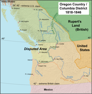
Oregon Country was a large region of the Pacific Northwest of North America that was subject to a long dispute between the United Kingdom and the United States in the early 19th century. The boundaries of the area, which had been created by the Treaty of 1818 without recognizing indigenous claims to the area, consisted of the land north of 42° N latitude, south of 54°40′ N latitude, and west of the Rocky Mountains down to the Pacific Ocean and east to the Continental Divide. Article III of the 1818 treaty gave joint control to both nations for ten years, allowed land to be claimed, and guaranteed free navigation to all mercantile trade. However, both countries disputed the terms of the international treaty. Oregon Country was the American name while the British used Columbia District for the region. Meanwhile, Indigenous nations had lived in the area since time immemorial, though with little legal recognition in the American and British legal systems. Evidence along the Salmon River shows people lived there at least 16,000 years ago, and may have populated the continent after migrating along the Pacific Coast, then following up the Columbia River into the interior.

The Oregon boundary dispute or the Oregon Question was a 19th-century territorial dispute over the political division of the Pacific Northwest of North America between several nations that had competing territorial and commercial aspirations in the region.

The history of British Columbia covers the period from the arrival of Paleo-Indians thousands of years ago to the present day. Prior to European colonization, the lands encompassing present-day British Columbia were inhabited for millennia by a number of First Nations.

Nootka Sound is a sound of the Pacific Ocean on the rugged west coast of Vancouver Island, in the Pacific Northwest, historically known as King George's Sound. It separates Vancouver Island and Nootka Island, part of the Canadian province of British Columbia. It played a historically important role in the maritime fur trade.

The lieutenant governor of British Columbia is the viceregal representative of the Canadian monarch, King Charles III, in the province of British Columbia, Canada. The office of lieutenant governor is an office of the Crown and serves as a representative of the monarchy in the province, rather than the governor general of Canada. The office was created in 1871 when the Colony of British Columbia joined the Confederation. Since then the lieutenant governor has been the representative of the monarchy in British Columbia. Previously, between 1858 and 1863 under colonial administration the title of lieutenant governor of British Columbia was given to Richard Clement Moody as commander of the Royal Engineers, Columbia Detachment. This position coexisted with the office of governor of British Columbia served by James Douglas during that time.

The Colony of Vancouver Island, officially known as the Island of Vancouver and its Dependencies, was a Crown colony of British North America from 1849 to 1866, after which it was united with the mainland to form the Colony of British Columbia. The united colony joined Canadian Confederation, thus becoming part of Canada, in 1871. The colony comprised Vancouver Island and the Gulf Islands of the Strait of Georgia.

The Colony of British Columbia was a crown colony in British North America from 1858 until 1866 that was founded by Richard Clement Moody, who was selected to 'found a second England on the shores of the Pacific', who was Chief Commissioner of Lands and Works for British Columbia and the first Lieutenant-Governor of British Columbia. Prior to the arrival of Moody's Royal Engineers, Columbia Detachment, the Colony's supreme authority was its Governor James Douglas, who was the Governor of the neighbouring colony of Vancouver Island.

The Spanish word ranchería, or rancherío, refers to a small, rural settlement. In the Americas the term was applied to native villages or bunkhouses. Anglo-Americans adopted the term with both these meanings, usually to designate the residential area of a rancho in the American Southwest, housing aboriginal ranch hands and their families. The term is still used in other parts of Spanish America; for example, the Wayuu tribes in northern Colombia call their villages rancherías.

Treaty 8, which concluded with the June 21, 1899, signing by representatives of the Crown and various First Nations of the Lesser Slave Lake area, is the most comprehensive of the eleven Numbered Treaties. The agreement encompassed a land mass of approximately 840,000 km2 (320,000 sq mi). Treaty territory, which includes thirty-nine First Nation communities in northern Alberta, northwestern Saskatchewan, northeastern British Columbia, and the southwest portion of the Northwest Territories, making it the largest of the numbered treaty in terms of area. The treaty was negotiated just south of present-day Grouard, Alberta.

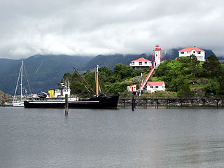
Yuquot, also known as Friendly Cove, is a small settlement of around six people—the Williams family of the Mowachaht band—plus two full-time lighthouse keepers, located on Nootka Island in Nootka Sound, just west of Vancouver Island, British Columbia, Canada. It was the summer home of Chief Maquinna and the Mowachaht/Muchalaht (Nuu-chah-nulth) people for generations, housing approximately 1,500 people in 20 traditional wooden longhouses. The name means "Wind comes from all directions" in Nuu-chah-nulth.
The history of immigration to Canada details the movement of people to modern-day Canada. The modern Canadian legal regime was founded in 1867, but Canada also has legal and cultural continuity with French and British colonies in North America that go back to the 17th century, and during the colonial era, immigration was a major political and economic issue with Britain and France competing to fill their colonies with loyal settlers. Until then, the land that now makes up Canada was inhabited by many distinct Indigenous peoples for thousands of years. Indigenous peoples contributed significantly to the culture and economy of the early European colonies to which was added several waves of European immigration. More recently, the source of migrants to Canada has shifted away from Europe and towards Asia and Africa. Canada's cultural identity has evolved constantly in tandem with changes in immigration patterns.

The history of Oregon, a U.S. state, may be considered in five eras: geologic history, inhabitation by native peoples, early exploration by Europeans, settlement by pioneers, and modern development.
Jackson's or Jacksons may refer to:
The Columbia Detachment of the Royal Engineers was a contingent of the Royal Engineers of the British Army that was responsible for the foundation of British Columbia as the Colony of British Columbia (1858–66). It was commanded by Colonel Richard Clement Moody, FICE FRGS RIBA, Kt. (France).
The Nisga'a Final Agreement, also known as the Nisga'a Treaty, is a treaty that was settled between the Nisg̱a'a, the government of British Columbia, and the Government of Canada that was signed on 27 May 1998 and came into effect on May 11, 2000. As part of the settlement in the Nass River valley nearly 2,000 km2 (800 sq mi) of land was officially recognized as Nisg̱a'a, and a 300,000 cubic decametres (1.1×10¹⁰ cu ft) (approx. 240,000 acre-feet) water reservation was also created. Bear Glacier Provincial Park was also created as a result of this agreement. Thirty-one Nisga'a placenames in the territory became official names. The land-claim settlement was the first formal modern day comprehensive treaty in the province— the first signed by a First Nation in British Columbia since the Douglas Treaties in 1854 (pertaining to areas on Vancouver Island) and Treaty 8 in 1899 (pertaining to northeastern British Columbia). The agreement gives the Nisga'a control over their land, including the forestry and fishing resources contained in it.
Jackson Bay is a settlement in British Columbia. It lies on a northerly inlet from Johnstone Strait north of Hardwicke Island. It is within Topaze Harbour, a good anchorage for ships.