Bekwai is a town and the capital of the Bekwai Municipal, a municipality in the Ashanti Region of Ghana. Bekwai is the seventy-ninth most populous settlement in Ghana, with a population of 7,267 people as of 2013. Bekwai and Bekwai Municipal are south of Kumasi and north of Obuasi. As of 2021, the mayor of the municipal is Hon. Kwaku Kyei Baffour.
Nkawie is a large agrarian and service town and the capital of Atwima Nwabiagya Municipality, a district in the Ashanti Region of Ghana. Nkawie is located on the western stretch of the Kumasi Bibiani road and bounded by two other major towns. - Toase and Abuakwa. It is home to prosperous business men in Ghana. There is a government hospital, a fire service station, a secondary technical institution and other government institutions like the courts, education offices, health insurance office, post office and the new immigration offices. The Forestry Commission is the second highest revenue earner in the forestry services in Ghana. The Owabi dam also supplies water to the south of the municipality. The famous Barekese dam also located in the Municipality supplies water to about 75% of Kumasi. Politically, the Town is an electoral bank for the New Patriotic Party. Nkawie is the home town of former Ghanaian president John Kufuor.
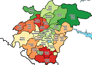
Bekwai Municipal Assembly is one of the forty-three districts in Ashanti Region, Ghana. Originally created as an ordinary district assembly in 1988 when it was known as Amansie East District, which it was created from the former Amansie District Council. Later, the western part of the district was split off by a decree of president John Agyekum Kufuor on 12 November 2003 to create Amansie Central District; thus the remaining part has retained as Amansie East District. Then the eastern part of the district was later split off to create Bosome Freho District on 29 February 2008; while the remaining part was elevated to municipal district assembly status on the same year to become and has since been renamed as Bekwai Municipal District. The municipality is located in the southern part of Ashanti Region and has Bekwai as its capital town.
Amansie Central District is one of the forty-three districts in Ashanti Region, Ghana. It was formerly part of the larger Amansie East District, until the western part of the district was split off by a decree of president John Agyekum Kufuor on 12 November 2003 to create Amansie Central District. The remaining part has been retained as Amansie East District. The district assembly is located in the southern part of Ashanti Region and has Jacobu as its capital town.
Bosome Freho District is one of the forty-three districts in Ashanti Region, Ghana. Originally it was formerly part of the then-larger Amansie East District in 2004; until the eastern part of the district was split off by a decree of president John Agyekum Kufuor on 29 February 2008 to create Bosome Freho District; thus the remaining part has been renamed as Bekwai Municipal District while it was elevated to municipal district assembly status on that same year. The district assembly is located in the southern part of Ashanti Region and has Asiwa as its capital town.
Osino is a town and the capital of Fanteakwa South district, of the Eastern region of Ghana, located on the Accra-Kumasi highway between Anyinam and Bunsu Junction. It is a semi-rural agrarian setting popular for the street-hawking of the sweetened boiled maize dough delicacy known as the "Osino Graphic".
Akrofuom is a town on Gyimi River in the Ashanti Region of Ghana. It is the capital of the Akrofuom District. The town is known for the Akrofuom Senior High Technical School. The school is a second cycle institution.
Fomena is a small town and the capital of the Adansi North District. The town is the seat of the paramount chief of the Adansi traditional council. The town is known as the place where the Fomena treaty was signed.
Kokofu is a town in the Bekwai Municipal district, a district in the Ashanti Region of Ghana.
Manso Atwere is a town in the Ashanti Region of Ghana. The town is known for the Mansoman Secondary School. The school is a second cycle institution.
Bompata is a town in the Ashanti Region of Ghana. The town is known for the Bompata Presby Secondary School. The school is a second cycle institution. Nana Effah-Apenteng has served as the traditional ruler for the Bompata Traditional area since 1976.
Aduman is a town in the Ashanti Region of Ghana. It is located in the Afigya-Kwabre District of Ghana. The town is known for the Aduman Senior High School. The school is a second cycle institution. The major occupation is Agriculture. It is about 15 km away from the Capital of Ashanti, and 3 km away from the District Capital. About 98% of the population are Christians. The remaining 2% form other religions.
Antoa is a town in the Ashanti Region of Ghana. The town is known for the Antoa Secondary School. The school is a second-cycle institution. This is also where the deity River Antoa Nyama is found.
Fawoade is a town in the Ashanti Region of Ghana. The town is known for the Simms Secondary School. The school is a second cycle institution.
Akumadan is the capital of Offinso North, a district in the Ashanti Region of Ghana. It has a population of about 20000. Akumadan township is well known for its agricultural activities. All sorts of food crops can be planted on its soil but tomatoes is the largest crop. 90 percent of natives above 18 years are tomato farmers. They produce more tomatoes than any other town in Ghana. It has a dam that helps to irrigate some farmlands within its reach during dry seasons. Cassava, pepper, onion, garden eggs, plantain, maize etc. are also abundant. A company called Fomghana has acquired a large area of land for planting trees near a river that irrigates it. Recently, the President Nana Addo Dankwa Akuffo-Addo formally opened a Greenhouse project. Its poised to train young people in Agric Technology.
Dadease is a town in the Ashanti Region of Ghana. The town is known for the Dadease Agriculture Secondary School. The school is a second cycle institution.
Effiduase is a town and is the capital of Sekyere East, a district in the Ashanti Region of Ghana. The Effiduase is known for the Effiduase Secondary Commercial School now Effiduase Senior High School and effiduasi senior high technical school. The Effiduase Secondary Commercial School is a second cycle institution. The Effiduase chief is Nana Adu Ameyaw II, Chief of the Ashanti sub-traditional council. Effiduase is made up of mostly traders. Effiduase is the district capital of Skyere East District. Effiduase houses the biggest hospital in its Sekyere East district.
Kumawu is a small town and is the capital of Sekyere Kumawu, a district in the Ashanti Region of Ghana. The town is known for the Tweneboa Kodua Secondary School. The school is a second cycle institution.
Busunya is a town in the Bono East Region of Ghana. The town is known for the Busunya High School. The school is a second cycle institution. Busunya also has a health centre.
Buoyem is a town in the Bono East region of Ghana. The town is known for the Buoyem High School. The school is a second cycle institution.


