
Fife is a council area, historic county, registration county and lieutenancy area of Scotland. It is situated between the Firth of Tay and the Firth of Forth, with inland boundaries with Perth and Kinross and Clackmannanshire. By custom it is widely held to have been one of the major Pictish kingdoms, known as Fib, and is still commonly known as the Kingdom of Fife within Scotland. A person from Fife is known as a Fifer. In older documents the county was very occasionally known by the anglicisation Fifeshire.

The Firth of Forth is the estuary, or firth, of several Scottish rivers including the River Forth. It meets the North Sea with Fife on the north coast and Lothian on the south.

North Queensferry is a village in Fife, Scotland, situated on the Firth of Forth where the Forth Bridge, the Forth Road Bridge, and the Queensferry Crossing all meet the Fife coast, 9 miles from the centre of Edinburgh. It is the southernmost settlement in Fife. The prefix North serves to distinguish it from South Queensferry, on the opposite shore of the Forth. Both towns derive their name from the ferry service established by Queen Margaret in the 11th century, which continued to operate at the town until 1964, when the Road Bridge was opened.

Dunfermline is a city, parish, and former Royal Burgh in Fife, Scotland, on high ground 3 miles (5 km) from the northern shore of the Firth of Forth. The city currently has an estimated population of 58,508. According to the National Records of Scotland, the greater Dunfermline area has a population of 76,210.

The M90 is a motorway in Scotland. It runs from Junction 1A of the M9 motorway, south of the Queensferry Crossing, to Perth. It is the northernmost motorway in the United Kingdom. The northern point goes to the western suburbs of Perth at Broxden. A small part of the M90 was originally numbered as the M85 motorway.

Inverkeithing is a coastal town and parish in Fife, Scotland, on the Firth of Forth, 9½ miles north west of Edinburgh city centre.

Rosyth is a town on the Firth of Forth, three miles south of the centre of Dunfermline. According to the census of 2011, the town has a population of 13,440.

Dunfermline and West Fife is a county constituency represented in the House of Commons of the Parliament of the United Kingdom. It was created for the 2005 general election from all of the old Dunfermline West and parts of the old Dunfermline East constituencies. The current MP is Douglas Chapman of the Scottish National Party (SNP).

Inverkeithing High School is a secondary school located in Inverkeithing, a historic former port town on the Fife coast.

The Fife Coastal Path is a Scottish long distance footpath that runs from Kincardine to Newburgh along the coastline of Fife. The path was created in 2002, originally running from North Queensferry to Tayport. It was extended in 2011 with a new section running from Kincardine to North Queensferry, then again in 2012 from Tayport to Newburgh. The path, which usually takes between one week and 10 days to walk in full, now runs for 187 kilometres (116 mi). The Fife Coastal Path is managed and maintained by Fife Coast and Countryside Trust, a registered environmental charity, and is designated as one of Scotland's Great Trails by NatureScot. About 500,000 people use the path every year, of whom about 35,000 walk the entire route.

Duloch, or Duloch Park, is a residential suburb of Dunfermline, in Fife, Scotland.
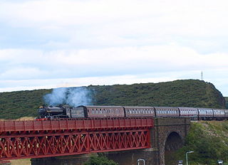
The Jamestown Viaduct is part of the northern approach to the Forth Bridge in Scotland. It crosses the hamlet of Jamestown and the village of North Queensferry in Fife.

Rosyth Castle is a fifteenth-century ruined tower house on the perimeter of Rosyth Naval Dockyard, Fife, Scotland.
St Columba's RC High School is a six-year comprehensive Roman Catholic secondary school, located in Dunfermline in Fife, Scotland.

Dunfermline was a local government district in the Fife region of Scotland from 1975 to 1996, lying to the south-west of the regional capital Glenrothes.

Halbeath is a village northeast of Dunfermline, Fife, Scotland. It derives its name from the Gaelic choil beath, which means "wood of birches", and began as a colliery village. In the summer of 1789, a coal pit was sunk at Halbeath, two and a half miles northeast of Dunfermline, and by 1821, 841 people were reported to be living in the village.
Humbug Park also previously known as Crossgates Greyhound Stadium is a football ground and former greyhound racing track on Inverkeithing Road in Crossgates, Fife, Scotland.

Inverkeithing Hillfield Swifts Football Club are a Scottish football club based at Dalgety Bay Sports centre in the town of Dalgety Bay, Fife. They compete in the East of Scotland League Premier Division, the sixth tier of Scottish football, having joined the league with their senior team in 2018 and gaining promotion from the First Division in 2020.
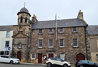
Inverkeithing Town House is a municipal building in the Townhall Street, Inverkeithing, Fife, Scotland. The structure, which is used as a base by members of the local community council, is a Category A listed building.
