
Munger, formerly spelt as Monghyr, is a twin city and a Municipal Corporation situated in the Indian state of Bihar. It is the administrative headquarters of Munger district and Munger Division. Munger was one of the major cities in Eastern India and undivided Bengal during Mughal period and British Raj. It is one of the major political, cultural, educational and commercial center of Bihar and Eastern India. Munger is situated about 180km from east of capital city Patna, about 480km west of Eastern India's largest city Kolkata and 1200km from country's capital New Delhi.
Sheohar is an administrative district in the state of Bihar in India. The district headquarters are located at Sheohar, and the district is a part of Tirhut Division. This district was carved out of Sitamarhi district in 1994 due to the extreme efforts of Raghunath Jha, former Union Minister. Eminent Hindi Novelist, Dr. Bhagwati Sharan Mishra was the first District magistrate of Sheohar. Sivas used to have a guest house in the Mehsi town of his time, which is still located in the name of Raja Bazar in East Champaran.The district occupies an area of 443 km² and has a population of 656,246. Sheohar is known for its greenery and cleanliness. Cadamba and teak are the principal trees of this district. Nilgai or blue bull is the regional animal of this area.

Patna district is one of the thirty-eight districts of Bihar state in eastern India. Patna, the capital of Bihar, is the district headquarters. The Patna district is a part of Patna division. The Patna district is divided into 6 Sub-divisions (Tehsils) i.e. Patna Sadar, Patna City, Barh, Masaurhi, Danapur and Paliganj.
Araria district is one of the thirty-eight districts of Bihar state, India. Araria district is a part of Purnia division. The district occupies an area of 2,830 km2 (1,090 sq mi). Araria town is the administrative headquarters of this district. Distance from Nepal border is only about 8 km from Forbesganj head quarter.

Sheikhpura district is one of the thirty-eight districts of the Indian state of Bihar. Sheikhpura is the administrative headquarter of this district. Sheikhpura district is a part of the Munger division. Sheikhpura was split from the Munger district into a separate district with headquarters in Sheikhpura on 31 July 1994 by Rajo Singh. As of 2011 it was the least populous district of Bihar.

Nawada district is one of the thirty-eight districts of the Indian state of Bihar. Nawada is its administrative headquarters. The district is the easternmost district of the Magadh division, one of the nine administrative divisions of Bihar. The area of the modern district was historically part of the Magadha, Shunga and Gupta empires. Koderma and Giridih districts of the state of Jharkhand lie on the southern border of the district; it also shares borders with the Gaya, Nalanda, Sheikhpura, and Jamui districts of Bihar.
Aurangabad district is one of the thirty-eight districts of Bihar state, India. It is currently a part of the Red Corridor.
Jamui is a district among 38 districts of Bihar state, India. The district was formed on 21 February 1991, when it was separated from Munger district. It is located at a longitude of 86° 13'E and the latitude is 24° 55'N.

Munger district is one of the thirty-eight districts of Bihar state in eastern India. The city of Munger is the administrative headquarters of this district. The district is a part of Munger Division. Its literacy rate of 73.3% is higher than the state literacy rate of 63.8%, but lower than national rate of 74.04%.

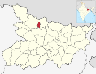
Lakhisarai district is one of the thirty-eight districts of Bihar state, India, and Lakhisarai town is the administrative headquarters of this district. Lakhisarai district is a part of Munger Division. The district occupies an area of 1,228 km2 (474 sq mi).

Munger division is an administrative geographical unit of Bihar state of India. Munger is the administrative headquarters of the division. The division consists of Munger district, Lakhisarai District, Jamui district, Khagaria district, and Sheikhpura district. Earlier all these districts were part of Munger district.
Jhajha is a city and a notified area in Jamui district in the Indian state of Bihar. It lies in the southern part of Bihar very close to the Jharkhand border. It falls on the Howrah - Mughalsarai mainline about halfway between Madhupur Junction and Kiul Junction.It is a very important and Main Market for the Nearby People and the city's People
Haveli Kharagpur is a town and One of the three subdivision in Munger district in the indian state of Bihar. Historically it was the centre of the medieval Kharagpur Raj chieftaincy.

Kiul Junction railway station, is one of the major railway junctions in Danapur division of East Central Railway. Kiul is connected to metropolitan areas of India, by the Howrah–Delhi main line via Mugalsarai–Patna route which runs along the historic Grand Trunk Road. The Danapur railway division's main line crosses Sahibganj loop line at the Kiul Junction. The main line crosses the Kiul River between Kiul Junction and Lakhisarai Junction. The Gaya–Kiul line also starts from the Kiul Junction.
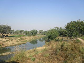
The Kiul River is a tributary of Ganges. It originates in Giridih of Jharkhand and flows through Lakhisarai, Sheikhpura and Jamui districts of the Indian state of Bihar and joins Harohar river in the Diara region.

Lohra Village Jamui district, state of Bihar in eastern India.

Lakhisarai Junction also called Luckeesarai Junction station code LKR, is one of the major railway junctions in East Central Railway. Lakhisarai is connected to metropolitan areas of India, by the Delhi–Kolkata Main Line via Mugalsarai–Patna route which runs along the historic Grand Trunk Road.
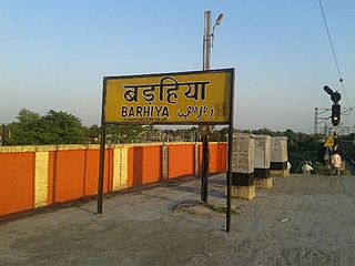
Barhiya, station code BRYA, serves the municipal city of Barahiya in the Lakhisarai district in the Indian state of Bihar. The station belongs to the Danapur railway division of East Central Railway. Barhiya is connected to metropolitan areas of India, by the Delhi–Kolkata main line via Mugalsarai–Patna route which runs along the historic Grand Trunk Road. Railways and roads are the main means of transport in the Barhiya region. Due to its location on Howrah–Patna–Mughalsarai main line, most of the Patna, Barauni-bound express trains coming from Howrah, Sealdah, Ranchi, Tatanagar, stop here. The Sahibganj loop line leaves Munger district, and enters Lakhisarai district near the Barhiya Station.
Sono is a 'tehsil'/block in the Jamui district of the Indian state of Bihar. It lies in the southern part of Bihar very close to the Jharkhand border. Sono block is divided into 19 Gram panchayats.

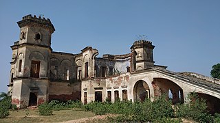
The Gidhaur Chieftaincy was a principality which controlled parts of South Bihar for much of the medieval period in India. The chieftaincy was named after the town of Gidhaur in Jamui district but its territory extended into the wider region.
