
Jangalbari Fort is a fort situated in Jangalbari village under Karimganj Upazila of Kishoreganj District. [1]
Jangalbari Fort is a fort situated in Jangalbari village under Karimganj Upazila of Kishoreganj District. [1]
After the battle of Egarasindhur, 16th century ruler Isa Khan took over the Janglabari Fort from Laksman Singh Hajra. [1] After Musa Khan became loyal to Mughal foce, the descendants of Isa Khan transferred their families from Sonargaon to Jangalbari Fort. [2]
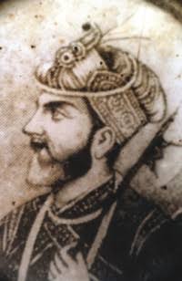
Isa Khan was the Bengali Muslim leader of the 16th-century Baro-Bhuiyan chieftains of Bengal and a zamindar of Khizrpur. During his reign, he successfully unified the chieftains of Bengal and resisted the Mughal invasion of Bengal. It was only after his death that the region fell totally under Mughal control. He remains an iconic figure throughout Bangladesh as a symbol of his rebellious spirit and unity.

Sonargaon is a historic city in central Bangladesh. It corresponds to the Sonargaon Upazila of Narayanganj District in Dhaka Division.

Brahmanbaria is a district in eastern Bangladesh located in the Chittagong Division. Geographically, it is mostly farmland and is topographically part of the Gangetic Plain. It is bounded by the districts of Kishoreganj and Habiganj to the north, Narsingdi District and Narayanganj to the west, Comilla to the south, and the Indian state of Tripura to its east. It was a part of Comilla until 15 February 1984.

Kishoreganj is a district in Dhaka Division, Bangladesh. Earlier it was a Mohkuma (মহকুমা) under the Mymensingh district. It was taken 2495.07 sq. km of land from Mymensingh district to form present day Kishoreganj District. Kishorganj consists of eight municipalities, 13 upazilas, 105 union parishads, 39 wards, 145 mahallas, 946 mouzas and 1775 villages.
Nalchity is an upazila of Jhalokati District in the division of Barisal, Bangladesh.
Sarail is an upazila of Brahmanbaria District located in the Chittagong Division and near the Dhaka Division, Bangladesh.
Kapasia is an upazila (sub-district) of Gazipur District in central Bangladesh, part of the Dhaka Division. It is located at 24.1000°N 90.5708°E, and is best known as the home upazila of Tajuddin Ahmad, the first Prime Minister of Bangladesh. The modern-day upazila was a part of the historic Bhawal Estate and falls within its boundary.
Kaliganj is an upazila (sub-district) of Gazipur District in central Bangladesh, part of the Dhaka Division.
Bajitpur is an upazila of Kishoreganj District in Bangladesh. Bajitpur was created by Baizid Kha. Formerly Bhairab and Kuliarchar were included in this town. This place is full of canals and rivers.Dilalpur river port here was famous in the subcontinent during the British period.
Bandar is an upazila (sub-district) of the Narayanganj District in central Bangladesh, part of the Dhaka Division. Bandar is a part of Greater Dhaka; the conurbation surrounding the Bangladeshi capital city of Dhaka.

Shitalakshya River is a distributary of the Brahmaputra. A portion of its upper course is known as Banar River or Banor River. In the Shitalakshya's initial stages, it flows in a southwest direction and then east of the city of Narayanganj in central Bangladesh until it merges with the Dhaleswari near Kalagachhiya. The river is about 110 kilometres (68 mi) long and at it widest, near Narayanganj, it is 300 metres (980 ft) across. Its flow, measured at Demra, has reached 74 cubic metres per second (2,600 cu ft/s). It remains navigable year round. The river flows through Gazipur district forming its border with Narsingdi for some distance and then through Narayanganj District.

Bangladesh's military history is intertwined with the history of a larger region, including present-day India, Pakistan, Nepal, Bhutan and Myanmar. The country was historically part of Bengal– a major power in South Asia and Southeast Asia.
Musa Khan was the leader of the Bara-Bhuiyans of Bengal following the death of his father, Isa Khan.
Egarasindur, and historically Yarasindur, is a village in Pakundia Upazila, Kishoreganj District, Dhaka Division, Bangladesh, on the east side of the Brahmaputra River. It is in the western part of the division, about 85 km from Dhaka by road. The village is mentioned in the Akbarnama by Abu'l-Fazl ibn Mubarak. Historians disagree about the history of Egarosindur. It was believed to have been settled about 1000 BCE, and archaeological finds include silver coins, iron axes, lances, bows and arrows. At that time, the village was a commercial center.

Sonakanda Fort is a river fort situated in Narayanganj, Bangladesh, on the eastern bank of Shitalakshya River. Though the time of its establishment could not be ascertained, historians believe that the river fort was built by Mir Jumla II, a Subahdar of Bengal under the Mughal Empire, to defend Dhaka and Narayanganj from pirates.
Masum Khan was a zamindar of Bengal. He was the eldest son and successor of Baro-Bhuiyan leader Musa Khan and the grandson of Isa Khan.

Musa Khan Mosque is one of the few Mughal structures on Bangladesh that stands in the southern part of the country's capital Dhaka. Built in 18th century the mosque holds significant historical values and is named after the son of medieval Bengal's one of the most prominent Baro-Bhuyans, Isa Khan's son Musa Khan. The structure was erected during the Mughal regime in Bengal by the grandson of Musa Khan, Diwan Munawar Khan.

The Greater Sylhet region predominantly includes the Sylhet Division in Bangladesh, and Karimganj district in Assam, India. The history of the Sylhet region begins with the existence of expanded commercial centres in the area that is now Sylhet City. Historically known as Srihatta and Shilhatta, it was ruled by the Buddhist and Hindu kingdoms of Harikela and Kamarupa before passing to the control of the Sena and Deva dynasties in the early medieval period. After the fall of these two Hindu principalities, the region became home to many more independent petty kingdoms such as Jaintia, Gour, Laur, and later Taraf, Pratapgarh, Jagannathpur, Chandrapur and Ita. After the Conquest of Sylhet in the 14th century, the region was absorbed into Shamsuddin Firoz Shah's independent principality based in Lakhnauti, Western Bengal. It was then successively ruled by the Muslim sultanates of Delhi and the Bengal Sultanate before collapsing into Muslim petty kingdoms, mostly ruled by Afghan chieftains, after the fall of the Karrani dynasty in 1576. Described as Bengal's Wild East, the Mughals struggled in defeating the chieftains of Sylhet. After the defeat of Khwaja Usman, their most formidable opponent, the area finally came under Mughal rule in 1612. Sylhet emerged as the Mughals' most significant imperial outpost in the east and its importance remained as such throughout the seventeenth century. After the Mughals, the British Empire ruled the region for over 180 years until the independence of Pakistan and India. There was a complete list of the different amils who governed Sylhet which was recorded in the office of the Qanungoh of Sylhet. However, most complete copies have been lost or destroyed. Dates from letters and seal traces show evidence that the amils were constantly changed. In 1947, when a referendum was held, Sylhet decided to join the Pakistani province of East Bengal. However, when the Radcliffe Line was drawn up, Karimganj district of Barak Valley was given to India by the commission after being pleaded by Abdul Matlib Mazumdar's delegation. Throughout the History of Sylhet, raids and invasions were also common from neighbouring kingdoms as well as tribes such as the Khasis and Kukis.
Khawāja Uthmān Khān Lōhānī, popularly known as Khwaja Usman, was a Pashtun chieftain and warrior based in northeastern Bengal. As one of the Baro-Bhuyans, he was a zamindar ruling over the northern parts of Bengal including Greater Mymensingh and later in South Sylhet. He was a formidable opponent to Man Singh I and the Mughal Empire, and was the last of the Afghan chieftains and rulers in Bengal. His defeat led to the surrender of all the remaining Pashtuns as well as the incorporation of the Sylhet region into the Bengal Subah. He is described as the most romantic figure in the history of Bengal. His biography can be found in the Baharistan-i-Ghaibi, Tuzk-e-Jahangiri as well as the Akbarnama.
Bayazid of Sylhet, also called Bayazid Karrani II, was a ruler in Sylhet during the early 17th century, in what is present-day Bangladesh. A prominent member of the Baro-Bhuiyan, Bayazid led military opposition against the Mughal Empire's expansion into eastern Bengal. His surrender following a sanguineous battle in 1612 ultimately resulted in their annexation of Sylhet.