
Villeray–Saint-Michel–Parc-Extension is a borough (arrondissement) in the city of Montreal, Quebec. It had a population of 143,853 according to the 2016 Census and a land area of 16.5 square kilometres (6.4 sq mi).

Saint Laurent Boulevard, also known as Saint Lawrence Boulevard, is a major street in Montreal, Quebec, Canada. A commercial artery and cultural heritage site, the street runs north–south through the near-centre of city and is nicknamed The Main, which is the abbreviation for "Main Street".

René Lévesque Boulevard, previously named Dorchester Boulevard is one of the main streets in Montreal, Quebec, Canada.

Saint Jacques Street, or St. James Street, is a major street in Montreal, Quebec, Canada, running from Old Montreal westward to Lachine.
Ville-Émard is a neighbourhood located in the Sud-Ouest borough of Montreal, Quebec, Canada.

Saint Denis Street is a major north–south thoroughfare in Montreal, Quebec.

Route 335 is a north-south regional route located on the north shore of the St. Lawrence River. from Montreal It serves the administrative regions of Montreal, Laval, Laurentides, and Lanaudière. It is the only secondary road whose route crosses the Island of Montreal. Between Autoroute 440 in Laval and Côte-Saint-Louis Road in Terrebonne, Route 335 is located in the right-of-way of the future Autoroute 19.

Mount Royal Avenue, once named Tannery Road, is a street in Montreal, Quebec, Canada. The main part of the street transects the borough of Le Plateau-Mont-Royal, from Park Avenue at the foot of Mount Royal, for which the road is named, to Frontenac St. Another section in Rosemont–La Petite-Patrie runs from Molson St. to Pie-IX Boulevard. West of Park Avenue, the road continues into Outremont, skirting the northern rim of the mountain to a terminus at Vincent d'Indy Avenue near the Édouard-Montpetit metro station.

Montreal-South was a suburb of Montreal located on the south shore of the St. Lawrence River founded in 1906. Montréal-Sud was created from land of the Saint-Antoine-de-Longueuil parish. Originally a village in its first five years, Montréal-Sud gained the status of city in 1911.

Sherbrooke Street is a major east–west artery and at 31.3 kilometres (19.4 mi) in length, is the second longest street on the Island of Montreal, Canada. The street begins in the town of Montreal West and ends on the extreme tip of the island in Pointe-aux-Trembles, intersecting Gouin Boulevard and joining up with Notre-Dame Street. East of Cavendish Boulevard this road is part of Quebec Route 138.

Bishop Street is a north–south street located in downtown Montreal, Quebec, Canada. With a total length of 0.6 km, it links Sherbrooke Street in the north to René Lévesque Boulevard in the south. Like neighbouring Crescent Street, Bishop is home to many pubs, bars, clubs and restaurants.

Peel Street (officially in French: rue Peel) is a major north–south street located in downtown Montreal, Quebec, Canada. The Street links Pine Avenue, near Mount Royal, in the north and Smith Street, in the Southwest borough, in the south. The street's southern end is at the Peel Basin of the Lachine Canal. The street runs through Montreal's shopping district. The Peel Metro station is named for the street.

De Maisonneuve Boulevard is a major westbound boulevard located in downtown Montreal, Quebec, Canada. It is named after the founder of Montreal, Paul Chomedey de Maisonneuve. It is a one-way street westbound.

Saint Antoine Street, formerly known as Craig Street, is a street located in Montreal, Quebec, Canada. It runs to the south of Downtown Montreal and north of Old Montreal and Griffintown and Saint-Henri. It crosses the Quartier international de Montréal. Between Atwater Avenue and Greene Avenue, the north side of the street is in Westmount.
Saint Joseph Boulevard is a major boulevard located east of Mount Royal in Montreal, Quebec, Canada. Although it is mainly residential, it is a major east–west artery in the Plateau Mont-Royal and the Rosemont–La Petite-Patrie boroughs. Its intersection with D'Iberville Street is known as the infamous Tunnel de la mort. Laurier metro station is located on the boulevard. It also intersects Route 335.

De la Gauchetiere Street is a street in Montreal, Quebec, Canada, running through downtown Montreal, the International District and Chinatown.
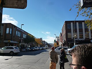
Jean Talon Street is one of the longest streets on the Island of Montreal. It runs from Décarie Boulevard in the west through Anjou in the east to Galeries d'Anjou. Jean Talon was the first Intendant of New France. In the Town of Mount Royal, it is called Dresden Avenue. In the Montreal Borough of Saint-Léonard, it is colloquially known as Via Italia.
Papineau Avenue is the longest north–south street in Montreal, Quebec, Canada. The part of the street between Henri Bourassa Boulevard and Quebec Autoroute 40 is the Montreal portion of Quebec Autoroute 19, commonly referred to as Autoroute Papineau. North of Henri Bourassa Boulevard, it becomes a true autoroute before crossing the Rivière des Prairies on the Papineau-Leblanc Bridge. In the south, the avenue ends at Notre-Dame Street.
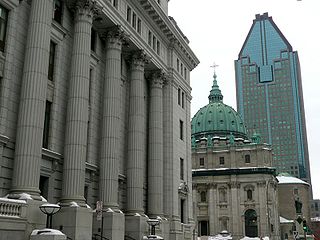
Metcalfe Street is a north–south street located in downtown Montreal, Quebec, Canada. It links Sherbrooke Street in the north and René Lévesque Boulevard in the south. It is best known for being the street on which the Sun Life Building, Mary, Queen of the World Cathedral, and other notable buildings are located. South of René Lévesque Boulevard, the street is known as Cathedral Street. The street borders the eastern side of both Dorchester Square and Place du Canada, to the south.

Assomption Boulevard is a main north–south street in the Montreal boroughs of Mercier–Hochelaga-Maisonneuve, Rosemont–La Petite-Patrie and Saint-Léonard.
