
St. Louis is the second-largest city in Missouri, United States. It sits near the confluence of the Mississippi and the Missouri Rivers, on the western bank of the latter. As of 2019, the city proper had an estimated population of around 300,000, while the bi-state metropolitan area, which extends into Illinois, had an estimated population of over 2.8 million, making it the largest metropolitan area in Missouri, the second-largest in Illinois, the seventh-largest in the Great Lakes Megalopolis, and the 20th-largest in the United States.

Council Bluffs is a city in and the county seat of Pottawattamie County, Iowa, United States. The city is the most populous in Southwest Iowa, and is a primary city of the Omaha-Council Bluffs Metropolitan Area. It is located on the east bank of the Missouri River, across from the city of Omaha, Nebraska. Council Bluffs was known, until at least 1853, as Kanesville. It was the historic starting point of the Mormon Trail. Kanesville is also the northernmost anchor town of the other emigrant trails, since there was a steam-powered boat to ferry their wagons, and cattle, across the Missouri River. In 1869, the first transcontinental railroad to California was connected to the existing U.S. rail network at Council Bluffs.
Highway 141 is a highway located in the western St. Louis metropolitan area. Its northern terminus is at Route 370 in Bridgeton; its southern terminus is at U.S. Route 61/U.S. Route 67 in Arnold, in Jefferson County. The northern stretches of the highway are often referred to as the Maryland Heights Expressway or Earth City Expressway.

The Kansas City metropolitan area is a bi-state metropolitan area anchored by Kansas City, Missouri. Its 14 counties straddle the border between the U.S. states of Missouri and Kansas. With 8,472 square miles (21,940 km2) and a population of more than 2.1 million people, it is the second-largest metropolitan area centered in Missouri and is the largest metropolitan area in Kansas, though Wichita is the largest metropolitan area centered in Kansas. Alongside Kansas City, Missouri, these are the suburbs with populations above 100,000: Overland Park, Kansas; Kansas City, Kansas; Olathe, Kansas; Independence, Missouri; and Lee's Summit, Missouri.
St. Charles Rock Road is the current name of what was the first road to traverse present-day St. Louis County, Missouri between St. Louis and St. Charles. For most of its length it is also known as Route 180.

Lexington Avenue, often colloquially abbreviated as "Lex", is an avenue on the East Side of the borough of Manhattan in New York City that carries southbound one-way traffic from East 131st Street to Gramercy Park at East 21st Street. Along its 5.5-mile (8.9-kilometer), 110-block route, Lexington Avenue runs through Harlem, Carnegie Hill, the Upper East Side, Midtown, and Murray Hill to a point of origin that is centered on Gramercy Park. South of Gramercy Park, the axis continues as Irving Place from 20th Street to East 14th Street.

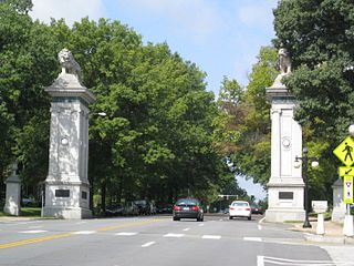
Lafayette Square is a neighborhood in St. Louis, Missouri, which is bounded on the north by Chouteau Avenue, on the south by Interstate 44, on the east by Truman Parkway, and on the west by South Jefferson Avenue. It surrounds Lafayette Park, which is the city's oldest public park — created by local ordinance in 1836.
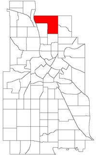
Columbia Park is a neighborhood in the Northeast community in Minneapolis.

Logan Square is a subway station on the Chicago Transit Authority's 'L' system, serving the Blue Line and the Logan Square neighborhood. It was the terminus of the Milwaukee Elevated until it was extended to Jefferson Park in 1970 and to O'Hare Airport in 1984 via the Kennedy Expressway. From Logan Square, trains run at intervals of 2–7 minutes during rush-hour periods, and take 14 minutes to travel to the Loop. O'Hare bound trains take 26 minutes to reach the airport.
In the U.S. state of Missouri, Interstate 70 (I-70) is generally parallel to the Missouri River. This section of the transcontinental Interstate begins at the Kansas state line on the Lewis and Clark Viaduct, concurrent with U.S. Routes 24, 40, and 169, and the east end is on the Stan Musial Veterans Memorial Bridge in St. Louis.
There have been 22 special routes of U.S. Route 66.

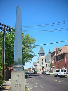
Benton Park West is a neighborhood located in South St. Louis City, Missouri, United States. The neighborhood is bounded by Jefferson Ave. on the east, Gravois Ave. on the north and west, and an irregular boundary consisting of Cherokee Street, S. Compton Ave., and Potomac Street to the south. The neighborhood is the conglomeration of two different neighborhoods in the 1970s, Compton Hill and Marquette-Cherokee. Parts of these two 1970s neighborhoods make up the current day Benton Park West. Marquette-Cherokee was bounded by Arsenal Street on the north, Bates Street on the south and Grand Boulevard on the west. Its eastern edge was the bank of the Mississippi River. Benton Park West has the highest percentage of Latino residents among St. Louis neighborhoods.

Benton Park is a neighborhood in southside St. Louis, Missouri, just west of the Soulard neighborhood. The official boundaries of the area are Gravois Avenue on the north, Cherokee Street on the south, I-55 on the east, and Jefferson Avenue on the west. Benton Park is unrelated to Benton Place, a private street located in Lafayette Square, St. Louis.

Forest Park Southeast (FPSE) is a neighborhood of St. Louis, Missouri. It is bordered by Interstate 64 to the north, Vandeventer Avenue to the east, Interstate 44 to the south, and Kingshighway Boulevard and Forest Park to the west. Adjoining neighborhoods include Kings Oak and The Hill to the west, Southwest Garden to the south, Botanical Heights to the southeast, Midtown to the east, and the Central West End to the north.

Fox Park is a neighborhood of St. Louis, Missouri. The neighborhood borders are Jefferson Avenue to the east, Interstate 44 to the north, Gravois Avenue to the south and Nebraska Avenue to the west. Surrounding neighborhoods include the Gate District, Compton Heights, Tower Grove East, Benton Park West and McKinley Heights.
The Gate District is a neighborhood of St. Louis, Missouri. The Gate District is defined as the area between Chouteau Avenue and Interstate 44 on the north and south and between South Jefferson Avenue and South Grand Boulevard on the east and west. This area is just south of the central corridor and west of Lafayette Square. The term Gate was added to define this neighborhood due to the number of ironclad gates lining the streets. Today, the neighborhood is the subject of increased gentrification.

Streetcars in St. Louis, Missouri operated as part of the transportation network of St. Louis from the middle of the 19th century through the early 1960s. During the first forty years of the streetcar in the city, a variety of private companies operated several dozen lines; from the start of the 20th century, most of these companies consolidated into the St. Louis Public Service Company, which served both the city of St. Louis and neighboring St. Louis County, Missouri. Other private companies, such as those serving the Metro East region or St. Charles, Missouri, continued separate operations. Starting in the 1930s and continuing through the 1960s, St. Louis Public Service ended all streetcar service, while other regional operators also ended their services.
The streets of St. Louis, Missouri, United States, and the surrounding area of Greater St. Louis are under the jurisdiction of the City of St. Louis Street Department. According to the Streets Division, there are 1,000-mile (1,600 km) of streets and 600-mile (970 km) of alleys within the city.

Grand Boulevard is a major, seven to five-lane wide, north-south thoroughfare that runs through the center of St. Louis, Missouri. It runs north through Carondelet Park in the south portion of the city to the Mississippi River north of the McKinley Bridge, about midway between Forest Park and the Mississippi River. Neighborhoods that it runs through include Dutchtown, Tower Grove East, Tower Grove South, Compton Heights, Tiffany, Midtown, Jef-Vander-Lou, Fairground, and College Hill.
Delmar Boulevard is a major east-west street in St. Louis, Missouri.