Jember Regency

Last updated
Jember Regency
Kabupaten Jember
Gumitir 03.jpg
Gumitir Mountain
Seal of Jember Regency.svg
Motto(s): 
Carya Dharma Praja Mukti
(Works and devotion for the sake of the country)
Indonesia location map.svg
Red pog.svg
Jember Regency
Location of Jember Regency in Indonesia
Coordinates: 8°10′8″S113°42′8″E / 8.16889°S 113.70222°E / -8.16889; 113.70222
Country Indonesia
Province East Java
Government
  RegentH. Hendy Siswanto
Area
  Total3,314.13 km2 (1,279.59 sq mi)
Population
 (mid 2023 estimate)
  Total2,600,663
  Density780/km2 (2,000/sq mi)
  [1]
Time zone UTC+7 (WIB)
Area code(s) +62-331, +62-336
Website jemberkab.go.id

Jember Regency is a regency of East Java province, in Indonesia. The land area is 3,314.13 km2, and the population was 2,332,726 at the 2010 census [2] and 2,536,729 at the 2020 Census; [3] the official estimate as at mid 2023 was 2,600,663 (comprising 1,298,852 males and 1,301,811 females). [1] Its administrative capital is the urban area of Jember, which with 366,932 inhabitants in mid 2023 is the third largest urban area in East Java province (after Surabaya and Malang) but does not have municipality or city status as it is split between three separate administrative districts (kecamatan). Jember is famous for its tobacco farms and traditional food called tape which is made of fermented cassava.

Contents

Geography

Jember Regency has a total area of 3,314.13.69 km2. It shares its borders with the regencies of Lumajang (to the west), Probolinggo, Bondowoso and Situbondo (to the north), and Banyuwangi (to the east). To the south lies the Indian Ocean, where the regency includes the island of Nusa Barong, located to the south of Java.

Administrative districts

Jember Regency consists of thirty-one districts (Indonesian: kecamatan), listed below with their areas and their populations at the 2010 Census [2] and the 2020 Census, [3] together with the official estimates as at mid 2023. [1] All districts have the same name as the towns or villages which provide their administrative centres. The table also includes the locations of the district administrative centres, the number of villages in each district (totaling 226 rural desa and 22 urban kelurahan - the latter comprising the 3 districts forming the Jember urban area), and its post code(s).

The Regent's Office Regent's office Jember.jpeg
The Regent's Office
Kode
Wilayah
Name of
District
(kecamatan)
Area
in
km2
Pop'n
Census
2010
Pop'n
Census
2020
Pop'n
Estimate
mid 2023
Admin
centre
No.
of
villages
Post
code(s)
35.09.02Kencong65.4065,17371,43071,327Kencong568167
35.09.04Gumukmas90.5379,22487,72489,412Gumukmas868165
35.09.08Puger (a)158.97114,506123,763125,496Puger Kulon1268164
35.09.11Wuluhan (b)139.26114,695123,999128,426Dukuhdempok768162
35.09.12Ambulu (c)101.41105,103116,361120,660Ambulu768172 (d)
35.09.18Tempurejo (e)515.9970,66378,92681,515Tempurejo868173
35.09.30Silo344.42103,850108,150111,292Sempolan968184
35.09.26Mayang57.7848,36250,97152,550Tegalrejo768182 (f)
35.09.23Mumbulsari90.0062,33968,00970,018Mumbulsari768174
35.09.16 Jenggawah 61.2481,31887,68291,175Wonosari868171
35.09.17Ajung58.8474,41682,04685,662Klompangan768175
35.09.13Rambipuji55.0078,93486,83488,426Rambipuji868152
35.09.10Balung49.3977,00581,68084,240Balung Lor868161
35.09.05Umbulsari71.4669,53978,24579,247Umbulsari1068166
35.09.07Semboro45.2043,47549,07050,049Semboro668157
35.09.01Jombang53.8950,00355,55356,229Jombang668168
35.09.03Sumberbaru161.0499,416115,270115,692Yosorati1068156
35.09.06Tanggul202.6282,76093,05793,921Tanggul Kulon868155
35.09.09Bangsalsari161.75113,905124,264127,888Bangsalsari1168154
35.09.14Panti181.0059,39965,08466,933Glagahwero768153
35.09.15Sukorambi46.9237,95041,16142,416Sukorambi568151
35.09.22Arjasa35.8838,05541,29542,597arjasa668191
35.09.24Pakusari31.2641,71345,05946,826Sumberpinang768181
35.09.27Kalisat52.6774,96278,42880,687Glagahwero1268193 (g)
35.09.28Ledokombo133.8462,52868,19370,455Sumberlesung1068196
35.09.31Sumberjambe132.9360,12662,63564,765Sumberjambe968195
35.09.29Sukowono45.1358,73460,31762,335Sukowono1268194
35.09.25Jelbuk73.3831,96232,33933,692Jelbuk668192
35.09.19Kaliwates (h)24.74111,861125,855127,156Manggli768131 - 68137
35.09.21Sumbersari (h)35.98126,279132,802136,528Karangrejo768121 - 68126
35.09.20Patrang (h)36.7194,471100,527103,048Patrang868111 - 68118
Totals3,314.132,332,7262,536,7292,600,663248

Notes: (a) includes the substantial offshore island of Nusa Barong (Pulau Nusa Barong, which forms the administrative village - or desa - of Puger Wetan) as well as 13 much smaller offshore islands.
(b) includes 2 small offshore islands. (c) includes 12 small offshore islands. (d) except Karanganyar village, which has the post code of 68132. (e) includes 22 small offshore islands.
(f) except Tegalrejo village, which has the post code of 68118. (g) except Plalangan village, which has the post code of 68113.
(h) the last three districts (indicated by "(h)" above) together constitute the urban area of Jember town.

Jember urban area

The "town" of Jember is composed of 3 separate districts (kecamatan) but has no overall administration. It is subdivided into 22 kelurahan as follows:

Climate

Climate data for Jember
MonthJanFebMarAprMayJunJulAugSepOctNovDecYear
Mean daily maximum °C (°F)30.1
(86.2)
30.4
(86.7)
30.6
(87.1)
31.0
(87.8)
30.7
(87.3)
30.2
(86.4)
30.0
(86.0)
30.3
(86.5)
31.0
(87.8)
31.5
(88.7)
31.4
(88.5)
30.6
(87.1)
30.6
(87.2)
Daily mean °C (°F)25.2
(77.4)
25.2
(77.4)
25.2
(77.4)
25.3
(77.5)
25.3
(77.5)
24.5
(76.1)
24.3
(75.7)
24.5
(76.1)
25.1
(77.2)
25.8
(78.4)
25.9
(78.6)
25.5
(77.9)
25.2
(77.3)
Mean daily minimum °C (°F)21.5
(70.7)
21.3
(70.3)
21.5
(70.7)
21.3
(70.3)
21.0
(69.8)
20.1
(68.2)
19.7
(67.5)
19.5
(67.1)
20.0
(68.0)
20.9
(69.6)
21.5
(70.7)
21.6
(70.9)
20.8
(69.5)
Average precipitation mm (inches)432.6
(17.03)
361.0
(14.21)
388.4
(15.29)
240.4
(9.46)
173.4
(6.83)
88.0
(3.46)
72.4
(2.85)
43.5
(1.71)
88.6
(3.49)
197.8
(7.79)
318.9
(12.56)
421.8
(16.61)
2,826.8
(111.29)
Average precipitation days18.818.216.511.07.76.23.52.12.02.85.815.0109.6
Source: weatherbase [4]

Demographics

There were 2,332,726 people living in Jember Regency at the 2010 Census. The population has risen by 2020 to 2,536,729; the official estimate as at mid 2023 was 2,600,663, [1] giving an average density of about 784.72 people/km2.

Ethnic backgrounds

Jember Regency is an heterogeneous area where many ethnic groups are mingled and live together. Most of its population are Javanese and Madurese people, with a small percentage of ethnic Chinese, Balinese, Arabic and Indian.

Language

Most citizens speak the Javanese language or the Madurese language, and sometimes a mixed dialect of both Javanese and Madurese languages. Many citizen speak Indonesian for official and business purposes only, and to communicate with non-Javanese or non-Madurese people.

Jember Fashion Carnival

The Jember Fashion Carnaval is an annual event. In the tenth carnival in 2011, over 600 participants walked along the world's longest catwalk. It ran for 3.6 kilometres (2.2 mi), along Jalan P.B. Sudirman (Central Park) and Jalan Gajah Mada up to the Jember Sport Hall. [5]

Airport

An expansion of dormant Notohadinegoro Airport was verified for reuse/operational in June 2014. The airport now has 1,705 meters runway and was ready to serve up to ATR 72/600.

However, the airport has been closed since April 2020 with no plans to reopen. High jet fuel prices and a lack of demand make Notohadinegoro Airport unprofitable for domestic airlines.

[6]

Notable people

See also

Related Research Articles

<span class="mw-page-title-main">Jombang Regency</span> Regency of Indonesia

Jombang Regency is a regency of East Java, Indonesia, situated to the southwest of Surabaya. The capital of the regency is the town of Jombang. The regency has an area of 1,159.50 km2 and a population of 1,202,407 at the 2010 census and 1,318,062 at the 2020 census; the official estimate as of mid-2023 was 1,370,510. It became a regency in 1910. It was the birthplace of Abdurrahman Wahid, the 4th president of Indonesia.

<span class="mw-page-title-main">Bondowoso Regency</span> Regency of Indonesia

Bondowoso Regency is a landlocked regency in East Java, Indonesia. It covers an area of 1,560.10 km2, and had a population of 736,772 at the 2010 Census and 776,151 at the 2020 Census; the official estimate as of mid-2023 was 796,911. The most common languages are Madurese and Javanese, although Madurese is the majority. The nearest large city is Surabaya, approximately five hour's drive away.

<span class="mw-page-title-main">Sikka Regency</span> Regency in Lesser Sunda Islands, Indonesia

Sikka is a regency within East Nusa Tenggara province, Indonesia, on the island of Flores. It is bordered to the west by Ende Regency and to the east by East Flores Regency. It covers an area of 1,675.36 km2 and had a population of 300,301 at the 2010 census and 321,953 at the 2020 Census; the official estimate as at mid 2023 was 335,360 - comprising 163,060 males and 172,300 females). The capital is the town of Maumere, which comprises the districts of Alok Barat, Alok and Alok Timur.

<span class="mw-page-title-main">Wonosobo Regency</span> Regency in Indonesia

Wonosobo Regency is a regency in Central Java province in Indonesia. The administrative centre of the regency is located in the town of Wonosobo, located at 7.3684940°S 109.8983841°E, about 120 km from Semarang on the Dieng Plateau. The regency's area is 984.68 km2 and its population was 754,883 at the 2010 census and 879,124 at the 2020 census; the official estimate as at mid 2023 was 909,664.

<span class="mw-page-title-main">Mojokerto</span> City in East Java, Indonesia

Mojokerto is a city in East Java Province of Indonesia. It is located 40 km southwest of Surabaya, the provincial capital, and constitutes one of the component units of the Surabaya metropolitan area which comprises Gresik Regency, Bangkalan Regency, Mojokerto Regency, Mojokerto City, Surabaya City, Sidoarjo Regency, and Lamongan Regency. The city covers an area of 20.21 km2, and had a population of 120,196 at the 2010 census and 132,434 at the 2020 Census; the official estimate as of mid-2023 was 141,785.

<span class="mw-page-title-main">Klaten Regency</span> Regency in Indonesia

Klaten Regency is a regency in Central Java province in Indonesia. It covers an area of 701.52 km2 and had a population of 1,130,047 at the 2010 Census and 1,260,506 at the 2020 Census; the official estimate as at mid 2023 was 1,284,386. Its administrative centre is in the town of the same name; the town extends over 35.85 km2 to encompass three of the regency's districts, with a combined total of 135,681 inhabitants in mid 2023; a fourth district (Kalikotes) is part of its urban area.

<span class="mw-page-title-main">Bangkalan Regency</span> Regency in Indonesia

Bangkalan Regency is a regency of East Java province in Indonesia. The seat of its government is the town of Bangkalan. The regency is located on the west side of Madura Island, bordering Sampang Regency to the east, Java Sea to the north, and Madura Strait to the west and the south sides. It covers an area of 1,260.15 km2, and had a population of 906,761 at the 2010 census and reached 1,060,377 at the 2020 census; however the official estimate as at mid-2023 showed a decline to 1,047,306 – comprising 515,428 males and 531,878 females.

<span class="mw-page-title-main">Pamekasan Regency</span> Regency of Indonesia

Pamekasan Regency is a regency (kabupaten) of the province of East Java, Indonesia. It is located on Madura Island approximately 120 kilometres (75 mi) east of Surabaya, the provincial capital. The regency covers an area of 792.30 square kilometres (305.91 sq mi), and at the 2010 census it had a population of 795,918 ; at the 2020 census the total was 850,057 and the official estimate as of mid-2023 was 882,837 – comprising 431,891 males and 450,946 females. The administrative capital is the town of Pamekasan.

<span class="mw-page-title-main">Trenggalek Regency</span> Regency of Indonesia

Trenggalek Regency is a regency (kabupaten) in East Java, Indonesia.

<span class="mw-page-title-main">Selayar Islands Regency</span> Regency in Sulawesi, Indonesia

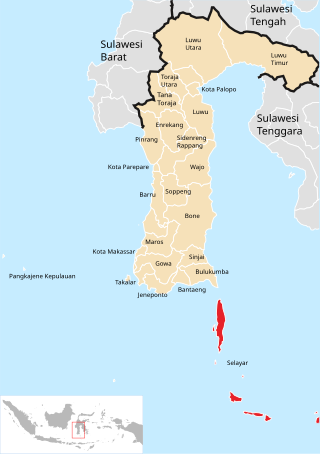
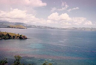
The Selayar Islands Regency is a regency of Indonesia in South Sulawesi province that covers the Selayar Islands, which lie southeast of the southern peninsula of Sulawesi. The archipelago consists of the group's main island, which is surrounded by 41 smaller islands around its coast; further to the southeast lies a widespread group of islands, including the huge atoll of Takabonerate. The regency covers an area of 1,357.03 km2, and had a population of 103,596 at the 2000 Census, 122,055 at the Census of 2010 and 137,071 at that of 2020. The official estimate for mid 2022 was 139,145. The administrative centre is the town of Benteng on Selayar Island. The Selayar Straits separate the regency from Sulawesi island.

<span class="mw-page-title-main">Brebes Regency</span> Regency of Indonesia

Brebes is a regency in the northwestern part of Central Java province in Indonesia. It covers an area of 1,769.62km2, and it had a population of 1,733,869 at the 2010 Census and 1,978,759 at the 2020 Census; the official estimate as at mid 2023 was 2,043,077. Its capital is the large town of Brebes in the northeast corner of the regency, immediately adjacent to the neighbouring city of Tegal.

<span class="mw-page-title-main">Jepara Regency</span> Regency in Indonesia

Jepara is a regency in the northeast of the Indonesian province of Central Java. It covers an area of 1,020.25 km2 and had a population of 1,097,280 at the 2010 census and 1,184,947 at the 2020 census; the official estimate as at mid 2023 was 1,264,598. Its capital is Jepara town.

<span class="mw-page-title-main">West Sumba Regency</span> Regency in Lesser Sunda Islands, Indonesia

West Sumba Regency is a regency in East Nusa Tenggara Province of Indonesia. Established in 1958, the regency was considerably reduced on 2 January 2007 with the creation of new Regencies on Sumba Island under Law UU No.16 of that year. Its area is now 737.42 km2, and its population was 110,993 at the 2010 census and 145,097 at the 2020 Census; the official estimate as at mid 2023 was 152,414. It has its seat (capital) in (Kota) Waikabubak.

<span class="mw-page-title-main">Belu Regency</span> Regency in Lesser Sunda Islands, Indonesia

Belu Regency is a regency in East Nusa Tenggara province of Indonesia. Situated on the north side of Timor island, it adjoins the North Central Timor Regency to the west and the separate nation of East Timor to the east. Established on 20 December 1958, Belu Regency has its seat (capital) in the large town of Atambua.

<span class="mw-page-title-main">Kutai Kartanegara Regency</span> Regency in East Kalimantan, Indonesia

Kutai Kartanegara Regency is a regency of East Kalimantan Province, Indonesia. It has a land area of 27,263.10 km2 and a water area of 4,097 km2, geographically located between 1°18′40″S and 116°31′36″E. The population of the regency was 626,286 at the 2010 Census and 729,382 at the 2020 Census; the official estimate as of mid-2022 was 738,189. The town of Tenggarong is the capital of the regency.

<span class="mw-page-title-main">East Sumba Regency</span> Regency in Lesser Sunda Islands, Indonesia

East Sumba Regency is geographically the largest of the four regencies which divide the island of Sumba, within East Nusa Tenggara Province of Indonesia. It occupies 62% of the entire island, being much less densely populated than the western third. The town of Waingapu is the capital of East Sumba Regency. The population of East Sumba Regency was 227,732 at the 2010 Census and 244,820 at the 2020 Census; the official estimate as at mid 2022 was 255,498.

<span class="mw-page-title-main">West Sumbawa Regency</span> Regency in West Nusa Tenggara, Indonesia

West Sumbawa Regency is a Regency (Kabupaten) of the Indonesian Province of West Nusa Tenggara. It is located on the island of Sumbawa and has an area of 1,743.58 km2. The regency was created on 18 December 2003 from what were at that time the westernmost five districts (kecamatan) of Sumbawa Regency. The population at the 2010 Census was 114,754, and at the 2020 Census was 145,798; the official estimate as at mid 2023 was 152,950 comprising 77,030 males and 75,920 females. The capital is the town of Taliwang.

<span class="mw-page-title-main">East Flores Regency</span> Regency in East Nusa Tenggara, Indonesia

East Flores Regency is a regency in East Nusa Tenggara province of Indonesia. Established in 1958, the regency has its seat (capital) in Larantuka on Flores Island. It covers a land area of 1,812.58 km2, and it had a population of 232,605 as of the 2010 census and 276,896 at the 2020 Census; the official estimate as of mid-2023 was 288,310 - comprising 141,738 males and 146,572 females. The regency encompasses the eastern tip of the island of Flores, together with all of the adjacent islands of Adonara and Solor to the east of Flores, with some much smaller offshore islands. On 4 October 1999, the island of Lembata at the eastern end of the Solor Archipelago was separated from the East Flores Regency to create its own Regency.

<span class="mw-page-title-main">Manggarai Regency</span> Regency in East Nusa Tenggara, Indonesia

Manggarai Regency is a regency in East Nusa Tenggara province of Indonesia, situated on the island of Flores. Established in 1958 the regency was reduced in size and population by the separation of the more western districts to form West Manggarai Regency in 2003 and of the more eastern districts to form East Manggarai Regency in 2007. The area of the residual Manggarai Regency is 1,343.83 km2 and its population was 292,037 at the 2010 census and 312,855 at the 2020 census; the official estimate as at mid 2023 was 328,758. The capital of the regency is the town of Ruteng.

<span class="mw-page-title-main">Lumajang Regency</span> Regency in Indonesia

Lumajang Regency is a Regency (kabupaten) located in the East Java province of Indonesia. It covers an area of 1,790.90 sq. km, and had a population of 1,006,458 at the 2010 Census and 1,119,251 at the 2020 Census. The mid 2022 official estimate was originally stated to be 1,137,230, but was revised down to 1,097,504. The official estimate for mid 2023 was 1,108,487. The regency shares its land borders with Jember Regency, Probolinggo Regency, and Malang Regency, while it borders the Indian Ocean to the south.

References

  1. 1 2 3 4 Badan Pusat Statistik, Jakarta, 28 February 2024, Kabupaten Jember Dalam Angka 2024 (Katalog-BPS 1102001.3509)
  2. 1 2 Biro Pusat Statistik, Jakarta, 2011.
  3. 1 2 Badan Pusat Statistik, Jakarta, 2021.
  4. "Jember, Indonesia Travel Weather Averages (Weatherbase)".
  5. "Jangan Lewatkan Jember Fashion Carnaval 2011 - Media Travelista". Archived from the original on 2011-07-16. Retrieved 2011-07-16.
  6. "Kemenhub Verifikasi Bandara Jember". June 27, 2014.