Related Research Articles

The Institute of Public Affairs (IPA) is a conservative non-profit free market public policy think tank, which is based in Melbourne, Victoria, Australia. It advocates free-market economic policies, such as privatisation, deregulation of state-owned enterprises, trade liberalisation, deregulation of workplaces, abolition of the minimum wage, criticism of socialism, and repeal of Section 18C of the Racial Discrimination Act 1975. It also rejects large parts of climate science.

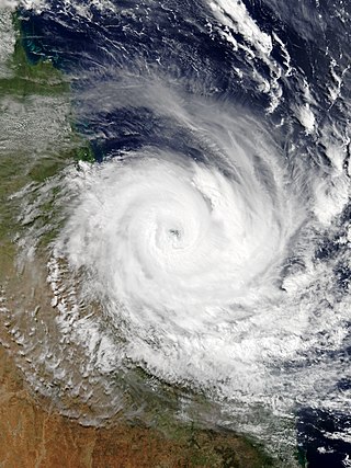
Severe Tropical Cyclone Larry was a tropical cyclone that made landfall in Australia during the 2005–06 Southern Hemisphere tropical cyclone season. Larry originated as a low pressure system over the eastern Coral Sea on 16 March 2006, and was monitored by the Australian Bureau of Meteorology in Brisbane, Australia. The low-pressure area organised into a tropical cyclone two days later and quickly strengthened into a Category 4 storm on the Australian tropical cyclone scale. Larry made landfall in Far North Queensland close to Innisfail, on 20 March 2006, as a Category 5 tropical cyclone on the Australian scale, with wind gusts reaching 240 kilometres per hour (150 mph), before dissipating over land several days later.
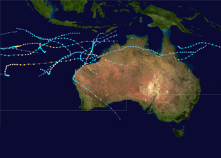
The 1999–2000 Australian region cyclone season was a slightly above average tropical cyclone season. It ran from 1 November 1999 to 30 April 2000. The regional tropical cyclone operational plan also defines a "tropical cyclone year" separately from a "tropical cyclone season", with the "tropical cyclone year" for this season lasting from 1 July 1999 to 30 June 2000.
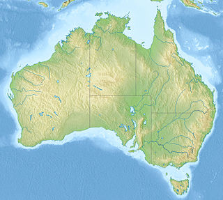
The Australian environment ranges from virtually pristine Antarctic territory and rainforests to degraded industrial areas of major cities. Forty distinct ecoregions have been identified across the Australian mainland and islands. Central Australia has a very dry climate. The interior has a number of deserts while most of the coastal areas are populated. Northern Australia experiences tropical cyclones while much of the country is prone to periodic drought. This dry and warm environment and exposure to cyclones, makes Australia particularly vulnerable to climate change -- with some areas already experiencing increases in wildfires and fragile ecosystems.

Australia's climate is governed mostly by its size and by the hot, sinking air of the subtropical high pressure belt. This moves north-west and north-east with the seasons. The climate is variable, with frequent droughts lasting several seasons, thought to be caused in part by the El Niño-Southern Oscillation. Australia has a wide variety of climates due to its large geographical size. The largest part of Australia is desert or semi-arid. Only the south-east and south-west corners have a temperate climate and moderately fertile soil. The northern part of the country has a tropical climate, varying between grasslands and desert. Australia holds many heat-related records: the continent has the hottest extended region year-round, the areas with the hottest summer climate, and the highest sunshine duration.

The 2006–07 Australian region cyclone season was a below average tropical cyclone season. It began on 1 November 2006 and ended on 30 April 2007; however, Tropical Cyclone Pierre formed on 17 May, after the official end date. The regional tropical cyclone operational plan also defines a tropical cyclone year separately from a tropical cyclone season, which runs from 1 July 2006 to 30 June 2007.
The Australian Environment Foundation (AEF) is a not-for-profit advocacy organisation. It has disputed the values of some mainstream environmental assertions, and also on occasion the evidence used to support those assertions. The AEF is climate-change-denying, pro-logging, pro-big business, anti-wind energy, and against the Murray-Darling Basin plan.

The 1978–79 Australian region cyclone season was the only season in which a reconnaissance aircraft flew into a tropical cyclone. Operationally, Australia's Bureau of Meteorology (BOM) tracked eleven tropical cyclones, while two additional systems were later added to the United States's Joint Typhoon Warning Center (JTWC) best track. Prior to 1985, the Australian region basin was defined as in the southern hemisphere between 80°E and 160°E, with the modern day season boundaries ranging from 1 November to 30 April of the following year. The first storm, an unnamed system, developed on 19 November 1978. The final cyclone, Kevin, dissipated by 12 May 1979. Tropical cyclones in this area were monitored by three Tropical Cyclone Warning Centres (TCWCs): the BOM in Perth, Darwin, and Brisbane.

Severe Tropical Cyclone Aivu was a powerful late-season tropical cyclone that caused extensive damage across parts of Queensland, Australia in April 1989.

Severe Tropical Cyclone Nina was a significant tropical cyclone which impacted six island nations from December 1992 to January 1993. The system was first noted as a tropical low over the Cape York Peninsula on 21 December. Over the next few days the system moved south-westwards and moved into the Gulf of Carpentaria where it was named Nina, after it had developed into a tropical cyclone during 23 December. The system was subsequently steered south-eastwards by an upper level trough of low pressure, before it made landfall as a Category 2 tropical cyclone on the Cape York Peninsula near Cape Keerweer on 25 December. Over land the system weakened into a tropical low before it regenerated into a tropical cyclone over the Coral Sea on 28 December. The system subsequently moved north-eastwards, under the influence of Severe Tropical Cyclone Kina and an upper level ridge of high pressure. During 1 January 1993, Nina peaked with sustained wind speeds of 140 km/h (85 mph), as it affected Rennell, Bellona and Temotu provinces in the Solomon Islands. The system subsequently gradually weakened as it accelerated eastwards and affected Rotuma, Wallis and Futuna, Tonga and Niue. Nina was subsequently absorbed by Kina, while both systems were located near the Southern Cook Islands during 5 January.

The 2014–15 Australian region cyclone season was a slightly below average tropical cyclone season, though it featured numerous intense cyclones. The season officially ran from 1 November 2014, to 30 April 2015, however, a tropical cyclone could form at any time between 1 July 2014, and 30 June 2015, and would count towards the season total. During the season, tropical cyclones were officially monitored, by one of the five Tropical Cyclone Warning Centres (TCWCs) that are operated in this region.

The 2019–20 Australian region cyclone season was a below average tropical cyclone season for the waters surrounding Australia between longitudes 90°E and 160°E. The season officially began on 1 November 2019 and ended on 30 April 2020; however, tropical cyclones can form at any time of year, as evidenced by Tropical Cyclone Mangga during May 2020. As such, any system existing between 1 July 2019 and 30 June 2020 would count towards the season total. The season featured the region's second-latest start on record, with the formation of the first tropical low only occurring on 4 January 2020. A total of eight tropical cyclones formed during the season, which represents the region's least active season since the 2016–17 season. Three systems intensified further into severe tropical cyclones, and three systems made landfall within the region at tropical cyclone intensity. A total of 28 fatalities were caused, either directly or indirectly, as a result of impacts from the season's systems. Cyclone Ferdinand was the strongest of the season reaching Category 4 in late February 2020. However, it was the second-strongest storm, Cyclone Damien, that was the most damaging. Damien was the strongest tropical cyclone to strike Western Australia's Pilbara Region since Cyclone Christine in 2013, making landfall directly over the town of Dampier.

The 2018–19 South Pacific cyclone season was a below-average season that produced 5 tropical cyclones, 2 of which became severe tropical cyclones. The season officially runs from November 1, 2018, to April 30, 2019; however, a tropical cyclone could have formed at any time between July 1, 2018, and June 30, 2019, and would count towards the season total. During the season, tropical cyclones were officially monitored by the Fiji Meteorological Service, Australian Bureau of Meteorology, and New Zealand's MetService. The United States Armed Forces through the Joint Typhoon Warning Center (JTWC) also monitored the basin and issued warnings for American interests. RSMC Nadi attaches a number and an F suffix to tropical disturbances that form in or move into the basin, while the JTWC designates significant tropical cyclones with a number and a P suffix. The FMS, the BoM and MetService all use the Australian Tropical Cyclone Intensity Scale and estimate wind speeds over a period of ten minutes, while the JTWC estimates sustained winds over a 1-minute period, which are subsequently compared to the Saffir–Simpson hurricane wind scale (SSHWS).

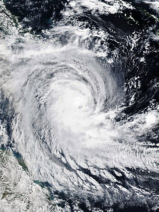
Severe Tropical Cyclone Marcia was a powerful tropical cyclone that made landfall at its peak strength over central Queensland, near Shoalwater Bay on 20 February 2015. The cyclone went on to affect various areas including Yeppoon and Rockhampton. It passed just to the west of Yeppoon as a Category 4 system, then traversed over the regional city of Rockhampton as a Category 2 system on the same day. Eventually, the cyclone weakened, moved southeast out to sea, before dissipating. Marcia caused at least A$750 million (US$587 million) worth of damage.

Severe Tropical Cyclone Lam was the strongest storm to strike Australia's Northern Territory since Cyclone Monica in 2006. It formed from the monsoon trough on February 12, 2015 in the Coral Sea. For much of its duration, the system moved westward due to a ridge to the south. The system crossed over the Cape York Peninsula and moved into the Gulf of Carpentaria, whereupon it gradually organized due to warm waters and favorable outflow. On February 16, the Bureau of Meteorology (BoM) classified it as a Category 1 on the Australian tropical cyclone intensity scale and gave it the name Lam. The storm intensified further while drifting toward the Wessel Islands, developing an eye and strengthening to the equivalence of a minimal hurricane on February 18. It strengthened to reach maximum sustained winds of 185 km/h (115 mph) early on February 19 before turning to the southwest, making it a Category 4 cyclone. That day, it made landfall on Northern Territory between Milingimbi and Elcho Island at peak intensity, and it rapidly weakened over land. About six hours after Lam moved ashore, Cyclone Marcia struck Queensland as a Category 5 cyclone, marking the first time on record that two storms of Category 4 intensity struck Australia on the same day.
Severe Tropical Cyclone Debbie in 2017 was the strongest tropical cyclone to strike Queensland since Marcia in 2015, and was the costliest tropical cyclone in Australia since Yasi in 2011. Forming as a tropical low on 23 March, the low gradually intensified into a named tropical cyclone on 25 March. After steadily strengthening offshore to a Category 4 system, Debbie eventually made landfall near Airlie Beach, at 12:40 AEST on 28 March. Afterwards, Debbie rapidly weakened into a tropical low by late 28 March, but continued to travel south, causing significant damage and flooding in the populous areas of South East Queensland and Northern Rivers. In total, the storm caused A$3.5 billion (US$2.67 billion) in damage and fourteen deaths across Australia, primarily as a result of extreme flooding. This makes Debbie the deadliest cyclone to hit Australia since Fifi in 1991.

Severe Tropical Cyclone Ernie was one of the quickest strengthening tropical cyclones on record. Ernie was the first Category 5 severe tropical cyclone in the Australian region since Cyclone Marcia in 2015, and also the strongest tropical cyclone in the Australian region since Cyclone Ita in 2014. Ernie developed from a tropical low into a cyclone south of Indonesia in the northeast Indian Ocean on 6 April 2017, and proceeded to intensify extremely rapidly to a Category 5 severe tropical cyclone. A few days later, on 10 April, the system was downgraded below cyclone intensity following a period of rapid weakening, located southwest of its original position. Ernie had no known impacts on any land areas.

Severe Tropical Cyclone Trevor was a powerful and large tropical cyclone that caused major damages across Papua New Guinea, Northern Territory and Queensland during March 2019. The twentieth tropical low, seventh tropical cyclone, and fourth severe tropical cyclone of the 2018-19 Australian region cyclone season, Trevor originated from a tropical low that formed to the east of Papua New Guinea.
Tropical Cyclone Ann was a small off-season tropical cyclone that brought minor impacts to the Solomon Islands, Far North Queensland and coastal regions of the Northern Territory's Top End during May 2019. Ann was the twenty-fifth tropical low, eleventh tropical cyclone, ninth Category 2 tropical cyclone and second off-season tropical cyclone of the 2018–19 Australian region cyclone season. The system developed from a tropical low that formed on 7 May in the South Pacific cyclone region. The low gradually intensified while moving southwards, and strengthened into a tropical cyclone on 11 May. The storm then turned to the west-northwest and continued to strengthen over the Coral Sea. Ann reached peak intensity on 12 May as a Category 2 tropical cyclone on the Australian scale, with 10-minute sustained winds of 100 km/h (65 mph) and a central barometric pressure of 990 hPa (29.23 inHg). One-minute sustained winds of 110 km/h (70 mph) made Ann equivalent to a strong tropical storm on the Saffir–Simpson hurricane wind scale. The storm began to decay soon afterwards, and weakened to a gale-force tropical low on 14 May. Ann made landfall near Lockhart River on Cape York Peninsula on 15 May, before re-emerging over water a few hours later. Ann maintained a steady west-northwestwards track for several days before dissipating as a tropical low near East Timor on 18 May.

Severe Tropical Cyclone Nora was a strong tropical cyclone that affected Far North Queensland and the northeastern Northern Territory during March 2018. The ninth named storm and third severe tropical cyclone of the 2017–18 Australian region cyclone season, Nora developed from a tropical low which formed near the Torres Strait on 19 March. The system initially moved quickly to the west-northwest, and then began tracking slowly southwestwards over the Arafura Sea while gradually developing. A turn to the east on 22 March brought the tropical low into a favourable environment for strengthening, and the system reached tropical cyclone intensity later that day. Nora then underwent a period of rapid intensification as it moved southeastwards into the Gulf of Carpentaria. The storm peaked on 23 March as a high-end Category 3 severe tropical cyclone with sustained winds of 155 km/h (96 mph) and a minimum barometric pressure of 958 hPa (28.29 inHg). Nora made landfall north of Pormpuraaw at about 13:00 UTC on 24 March as a minimal Category 3 system. Nora weakened steadily as it tracked southwards along the coast, and was downgraded to a tropical low the following day. Nora's remnants meandered over land for several days before moving back over the Gulf of Carpentaria and dissipating on 28 March.
References
- ↑ Melissa Fyfe, "Cool reception for new green group", The Age , 8 June 2005.
- ↑ Abbot, John; Marohasy, Jennifer (2017). "The application of machine learning for evaluating anthropogenic versus natural climate change". GeoResJ . 14: 36–46. Bibcode:2017GeoRJ..14...36A. doi:10.1016/j.grj.2017.08.001.
- ↑ Readfearn, Graham (26 August 2017). "Why the IPA's claim global warming is natural is junk science". The Guardian Australia . Archived from the original on 26 August 2017. Retrieved 26 August 2017.
- ↑ Walton, Craig (2005). Reclaiming Lost Provinces: A Century of Weed Biological Control in Queensland. Department of Natural Resources & Mines, Queensland. Reviewed here Archived 16 September 2006 at the Wayback Machine
- ↑ Early Scientific Publications :: Publications
- ↑ "Assessing host specificity in weed biological control, with particular reference to the lantana mealybug". University of Queensland Library, thesis search. 1998.
- ↑ "WWF Says 'Jump!', Governments Ask 'How High?' | Institute of Public Affairs Australia". Archived from the original on 4 March 2011. Retrieved 14 May 2011.
- ↑ "Jennifer Marohasy, Author at IPA - The Voice For Freedom". IPA - The Voice For Freedom. Retrieved 22 November 2022.
- ↑ Jennifer Marohasy, IPA Backgrounder Vol 15/5, December 2003,Myth and the Murray - measuring the real state of the river environment Archived 27 July 2008 at the Wayback Machine
- ↑ ABC Local Radio, VIC Country Hour, 04/06/2004, Institute of Public Affairs accepts irrigation funds.
- ↑ House of Representatives Standing Committee on Agriculture, Fisheries and Forestry, 2004, Inquiry into future water supplies for Australia’s rural industries and communities Archived 25 August 2008 at the Wayback Machine
- ↑ AAP MediaNet Press Releases, Media Release: Institute of Public Affairs, 30 April 2008; Andrew Trounson, Greg Roberts,"Climate sceptic's $350,000 grant to uni has 'no strings attached'", The Australian, 7 May 2008
- ↑ The Australian, 7 May 2008. Dispute over climate sceptic uni grant Archived 10 May 2008 at the Wayback Machine
- ↑ Report released on climate change - Broadcast 7/26/05
- ↑ Ockham's Razor - Broadcast 11/20/05
- ↑ 1997-1998 El Nino: the most recent event, Department of Atmospheric Science, University of Illinois
- ↑ Interview on Counterpoint - Broadcast 3/17/2008
- ↑ Marohasy, Jennifer (4 January 2020). "It has been hotter, fires have burnt larger areas". Jennifer Marohasy. Retrieved 22 November 2022.
- ↑ Marohasy, Jennifer (19 November 2020). "Unprecedented Panic Over Bushfire Impact – CLIMATE CHANGE THE FACTS" . Retrieved 22 November 2022.
- ↑ Courier Mail - You Call that a Category 5?
- ↑ Tropical Cyclone Marcia to reach Category 5 system at landfall
- ↑ Latest Weather Observations for Middle Percy Island
- ↑ Marohasy, "Just before the cyclone made landfall it passed over Middle Percy Island ... A wind gust of 208 km/hr was recorded at 4.30 am, which suggests Marcia was almost a Category 3 at this time"
- ↑ Professor Jon Nott Profile - James Cook University