
Jersey County is a county located in the U.S. state of Illinois. According to the 2020 census, it has a population of 21,512. The county seat and largest community is Jerseyville, with a population of 8,465. The county's smallest incorporated community is Fidelity, with a population of 114.

Jerseyville is the largest city in and the county seat of Jersey County, Illinois, United States. As of the 2010 U.S. census, the city had a total population of 8,465.

Keswick (/ˈkɛzˌwɪk/) is a community located in the Canadian province of Ontario. Situated in Cook's Bay on Lake Simcoe, 72 km (45 mi) north of Toronto. Keswick is part of the Town of Georgina, the northernmost municipality in the Regional Municipality of York. In the Canada 2016 Census, the municipal population of Keswick was 26,757.

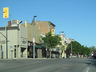
Listowel is an unincorporated community in Ontario, Canada, located in the Municipality of North Perth. It was created in 1998 during the amalgamation of several other communities in the northern section of Perth County, and the previously incorporated Town of Listowel dissolved with the creation of the Municipality of North Perth. Its population was 7,530 at the Canada 2016 Census in a land area of 6.65 square kilometres; at the time there were 3,159 occupied dwellings.

Eatonville is a neighbourhood in the Toronto, Ontario district of Etobicoke, west of the central core. Eatonville is bisected by Highway 427, with the community generally located north of Dundas Street West and south of Rathburn Road. Eatonville consists mainly of low density residential homes. The main arterial roads in the community, such as The West Mall, The East Mall and Burnhamthorpe Road, contain a mix of rental and condominium high-rise apartments and townhouses. Cloverdale Mall is in the neighbourhood, and there are community retail areas along Bloor Street West and Dundas Street West.

Ayton is a community in the municipality of West Grey, Grey County, Ontario, Canada.

Drayton is a community in Wellington County, Ontario, Canada. It is a part of the township of Mapleton. The village is on the corner of Wellington Road 8 and Wellington Road 11, geographically northwest of Fergus and southwest of Arthur.
Mitchell is a community in the municipality of West Perth, part of Perth County, Ontario, Canada. It is located at the intersection of Ontario Highways 8 and 23, 20 kilometres (12 mi) northwest of Stratford, and 60 kilometres (37 mi) north of London. Mitchell is no longer a separate entity. On January 1, 1998, the town amalgamated with the neighbouring Townships of Logan, Fullarton, and Hibbert to form the new Municipality of West Perth. As of 2016, the former town of Mitchell has a population of 4,573 in a land area of 4.81 square kilometres (1.86 sq mi); it has 1,827 occupied private dwellings.

The Elms is a neighbourhood in Toronto, Ontario, Canada. It is bordered by the Humber River to the east, Islington Avenue to the west, Thistletown to the north, and Highway 401 to the south.

The United Townships of Dysart, Dudley, Harcourt, Guilford, Harburn, Bruton, Havelock, Eyre and Clyde, commonly known as the Municipality of Dysart et al, is a municipality in Haliburton County in Central Ontario, Canada. The original townships were of the Canadian Land and Emigration Company.
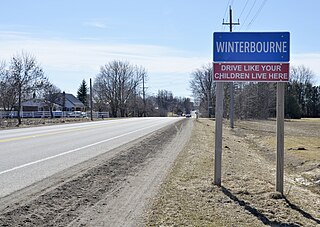
Winterbourne is a village located to the east of the Grand River in the township of Woolwich, Ontario in the Regional Municipality of Waterloo. It is located just northeast of the city of Waterloo. The fine stonework of the Scottish stonemasons can be seen in many of the older buildings throughout the settlement.

Copetown is a rural neighbourhood of the city of Hamilton, Ontario, Canada, located northeast of Brantford. William Cope, a United Empire Loyalist from the U.S. state of New York settled here in 1794. The community was renamed after his son Conradt in 1851. The current population of this community is approximately 130 residents.

Armadale is a neighbourhood that overlaps into the city of Markham and the former city of Scarborough in Toronto, Ontario, Canada. The historical community is situated in the south-east of Markham and north-east of Scarborough.
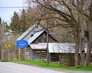
The small village of Ashton is located about 40 kilometres (25 mi) southwest of Downtown Ottawa, Ontario, at the intersection of Ashton Station Road and Flewellyn Road. Ashton Station Road runs through the centre of the community, and serves as the south-western boundary line for the City of Ottawa, thus making the eastern portion of the hamlet part of Ottawa, and the western portion part of Lanark County. The eastern portion of the community was originally part of Goulbourn Township, which was amalgamated into the City of Ottawa in 2001. It is home to approximately 200 residents.
Lynden is part of Flamborough, which is itself part of the city of Hamilton, Ontario, Canada. Lynden now has fewer than 500 residents. There used to be a train station in Lynden that went to Hamilton and Lynden provided goods to that city. Currently Lynden has many farmers, small business entrepreneurs and commuters to Hamilton, Cambridge, Dundas, Brantford and Toronto.

Locust Hill is a historic community of Markham, Ontario centred on Hwy. 7 and the Canadian Pacific Railway and within the boundaries of the future national Rouge Park.

Kirby is a rural hamlet located in the Municipality of Clarington in Durham Region in Ontario, Canada. On Highway 35/115, it is north of Orono, approximately a 45-minute drive east of Toronto. The community is named for Kirkby, North Yorkshire.
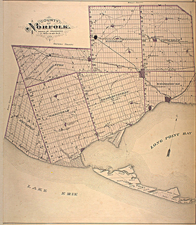
Norfolk County in the Canadian province of Ontario consists of a long list of communities. Its four designated population centres are Simcoe, Port Dover, Delhi, and Waterford.

Bermondsey is an neighbourhood in Toronto, Ontario, Canada. It covers a rough triangle with the Don Valley to the west, Eglinton Avenue to the northeast and O'Connor Drive to the southeast. It straddles the border of the former cities of North York and East York. The area is named after Bermondsey Drive that runs through the centre of the district and named after Peek Freans' head office location at Bermondsey.
