Jewish land purchase in Palestine

Last updated

Map showing Jewish-owned land as of 31 December 1944, including land owned in full, shared in undivided land and State Lands under concession. This constituted 6% of the total land area, of which more than half was held by the JNF and PICA Palestine Index to Villages and Settlements, showing Land in Jewish Possession as at 31.12.44.jpg
Map showing Jewish-owned land as of 31 December 1944, including land owned in full, shared in undivided land and State Lands under concession. This constituted 6% of the total land area, of which more than half was held by the JNF and PICA

In the 1880s, Jews began purchasing land and properties across Ottoman Palestine in order to expand the collective territorial ownership of the Yishuv. Large Jewish corporations and private Jewish buyers led this effort through multiple intermittent transactions that continued after Mandatory Palestine was established in 1918. The largest of these arrangements, known as the Sursock Purchases, resulted in the procurement of the Jezreel Valley and the Bay of Haifa by the 1930s. The purchase of land was often accompanied by the eviction of the Arab tenants. [2] On 1 April 1945, the British administration's statistics showed that Jewish buyers had legal ownership over approximately 5.67% of the Mandate's total land area, while state-owned domain was 46%. [3] [4] [5] By the end of 1947, Jewish ownership had increased to 6.6%. [6] This cycle of land acquisition ultimately ended when the Israeli Declaration of Independence yielded the founding of the Jewish state on 14 May 1948.

Contents

Background

Palestine agricultural land ownership by sub-district (1945) Palestine Land ownership by sub-district (1945).jpg
Palestine agricultural land ownership by sub-district (1945)

Towards the end of the 19th century, the creation of the Zionist movement resulted in many European Jews immigrating to Palestine. Most land purchases between the late 1880s and the 1930s were located in the coastal plain area, including "Acre to the North and Rehovoth to the South, the Esdraelon (Jezreel) and Jordan Valleys and to the lesser extent in Galilee". [8] These were the less inhabited coasts and valleys, which had high rates of malaria and were more easily bought. [9] The migration affected Palestine in many ways, including economically, socially, and politically.

The Talmud mentions the religious duty of settling the Land of Israel. [10] It also allows for the lifting of certain religious restrictions of Sabbath observance to further its acquisition and settlement. [11]

History and purchase policies

KKL collection boxes to fund land purchases in Palestine were distributed among Jews from 1904 onwards KKL tin.jpg
KKL collection boxes to fund land purchases in Palestine were distributed among Jews from 1904 onwards

In the first half of the 19th century, no foreigners were allowed to purchase land in Palestine. [12] This was official Ottoman policy until 1856 and in practice until 1867. [12] When it came to the national aspirations of the Zionist movement, the Ottoman Empire opposed the idea of Jewish self-rule in Palestine, fearing it might lose control of Palestine after recently having lost other territories to various European powers. It also took issue with the Jews, as many came from Russia, which sought the empire's demise. [13] In 1881 the Ottoman governmental administration (the Sublime Porte) decreed that foreign Jews could immigrate to and settle anywhere within the Ottoman Empire, except in Palestine and from 1882 until their defeat in 1918, the Ottomans continuously restricted Jewish immigration and land purchases in Palestine. [13] In 1892, the Ottoman government decided to prohibit the sale of land in Palestine to Jews, even if they were Ottoman citizens. [14] Nevertheless, during the late 19th century and the beginning of the 20th century, many successful land purchases were made through organizations such as the Palestine Jewish Colonization Association (PJCA), Palestine Land Development Company and the Jewish National Fund.

Jewish rabbis receiving the title deed for lands that they purchased from the Arab landowner in Mandatory Palestine, 1920s Jews purchasing Arab title deed in Palestine.tif
Jewish rabbis receiving the title deed for lands that they purchased from the Arab landowner in Mandatory Palestine, 1920s

The Ottoman Land Code of 1858 "brought about the appropriation by the influential and rich families of Beirut, Damascus, and to a lesser extent Jerusalem and Jaffa and other sub-district capitals, of vast tracts of land in Syria and Palestine and their registration in the name of these families in the land registers". [15] According to Palestinian-American anthropologist Nasser Abufarha, "In 1858 the Ottoman Authority introduced the law of tabu to fix rights of ownership of the land. Land owners were instructed to have their property inscribed in the land register. The tabu was resisted by the fellahin. They saw a threat to their community in registering their land for two main reasons: 1) the cultivated fields were classified as ardh ameriyeh (the land of the Emarit) and were taxed. Owners of registered fertile land were forced to pay tax on it; 2) data from the land register were used by the Turkish Army for the purpose of the draft. Owners of registered lands were often drafted to fight with the Turkish Army in Russia." [16]

In 1918, after the British conquest of Palestine, the military administration closed the Land Register and prohibited all sale of land. The Register was reopened in 1920, but to prevent speculation and ensure a livelihood for the fellahin, an edict was issued forbidding the sale of more than 300 dunams of land or the sale of land valued at more than 3000 Palestine pounds without the approval of the High Commissioner. [17]

From the 1880s to the 1930s, most Jewish land purchases were made in the coastal plain, the Jezreel Valley, the Jordan Valley and to a lesser extent the Galilee. [15] This was due to a preference for land that was cheap and without tenants. [15] There were two main reasons why these areas were sparsely populated. The first reason being when the Ottoman power in the rural areas began to diminish in the seventeenth century, many people moved to more centralized areas to secure protection against the Bedouin tribes. [15] The second reason for the sparsely populated areas of the coastal plains was the soil type. The soil, covered in a layer of sand, made it impossible to grow the staple crop of Palestine, corn. [15] As a result, this area remained uncultivated and underpopulated. [8] "The sparse Arab population in the areas where the Jews usually bought their land enabled the Jews to carry out their purchase without engendering a massive displacement and eviction of Arab tenants". [15]

In the 1930s, most of the land was bought from landowners. Of the land that the Jews bought, 52.6% were bought from non-Palestinian landowners, 24.6% from Palestinian landowners, 13.4% from government, churches, and foreign companies, and only 9.4% from fellaheen (farmers). [18]

On 31 December 1944, out of 1,732.63 dunums[ citation needed ] of land owned in Palestine by large Jewish Corporations and private owners, about 44% was in possession of Jewish National Fund. The table below shows the land ownership of Palestine by large Jewish Corporations (in square kilometres) on 31 December 1945.

Land ownership of Palestine by large Jewish corporations (in square kilometres) on 31 December 1945
CorporationsArea
JNF 660.10
PICA 193.70
Palestine Land Development Co. Ltd.9.70
Hemnuta Ltd16.50
Africa Palestine Investment Co. Ltd.9.90
Bayside Land Corporation Ltd.8.50
Palestine Kupat Am. Bank Ltd.8.40
Total906.80
Data is from Survey of Palestine (Vol I, p245). [19] [20]

By the end of the mandate, more than half the Jewish-owned land was held by the two largest Jewish funds, the Jewish National Fund and the Palestine Jewish Colonization Association.

By the end of the British Mandate period in 1948, Jewish farmers had cultivated 425,450 dunams of land, while Arab farmers had 5,484,700 dunams of land under cultivation. [21]

Arab anti-Zionist protests at the Damascus Gate, 8 March 1920 1920 demontration Palestine.jpg
Arab anti-Zionist protests at the Damascus Gate, 8 March 1920

Peel Commission

In 1936 the British government appointed the Peel Commission to investigate the reasons for the civil unrest in Palestine. Lord Peel's findings on land purchase were as follows:

A summary of land legislation enacted during the Civil Administration shows the efforts made to fulfill the Mandatory obligation in this matter. The Commission point to serious difficulties in connection with the legislation proposed by the Palestine Government for the protection of small owners. The Palestine Order in Council and, if necessary, the Mandate should be amended to permit of legislation empowering the High Commissioner to prohibit the transfer of land in any stated area to Jews, so that the obligation to safeguard the right and position of the Arabs may be carried out. Until survey and settlement are complete, the Commission would welcome the prohibition of the sale of isolated and comparatively small plots of land to Jews.

[...]

Up till now the Arab cultivator has benefited on the whole both from the work of the British Administration and the presence of Jews in the country, but the greatest care must now be exercised to see that in the event of further sales of land by Arabs to Jews the rights of any Arab tenants or cultivators are preserved. Thus, alienation of land should only be allowed where it is possible to replace extensive by intensive cultivation. In the hill districts there can be no expectation of finding accommodation for any large increase in the rural population. At present, and for many years to come, the Mandatory Power should not attempt to facilitate the close settlement of the Jews in the hill districts generally.

The shortage of land is due less to purchase by Jews than to the increase in the Arab population. The Arab claims that the Jews have obtained too large a proportion of good land cannot be maintained. Much of the land now carrying orange groves was sand dunes or swamps and uncultivated when it was bought.

Legislation vesting surface water in the High Commissioner is essential. An increase in staff and equipment for exploratory investigations with a view to increasing irrigation is recommended.

Report of the Palestine Royal Commission, July 1937 [22]

Economic impact

The fellahin who sold land in an attempt to turn "vegetable tracts into citrus groves became dependent on world markets and on the availability of maritime transportation. A decrease in the world market demand for citrus or a lack of means of transportation severely jeopardized the economic situation of these people". [8]

Impact on the local Arab populace

Director of Development Lewis French established a register of landless Arabs in 1931. [23] Out of 3,271 applicants, only 664 were admitted and the remainder rejected. [23] Porath suggests that the number of displaced Arabs may have been considerably larger, since French's definition of "landless Arab" excluded those who had sold their own land, those who owned land elsewhere, those who had since obtained tenancy of other land even if they were unable to cultivate it due to poverty or debt, and displaced persons who were not cultivators but had occupations such as ploughman or laborer. [23]

See also

Related Research Articles

<span class="mw-page-title-main">Afula</span> Place in Israel

Afula is a city in the Northern District of Israel, often known as the "Capital of the Valley" due to its strategic location in the Jezreel Valley. As of 2022, the city had a population of 61,519.

<span class="mw-page-title-main">Ma'alul</span> Place in Nazareth, Mandatory Palestine

Ma'alul was a Palestinian village, with a mixed population of primarily Muslims with a substantial minority of Palestinian Christians, that was depopulated and destroyed by Israel during the 1948 Arab-Israeli war. Located six kilometers west of the city of Nazareth, many of its inhabitants became internally displaced refugees, after taking refuge in Nazareth and the neighbouring town of Yafa an-Naseriyye. Despite having never left the territory that came to form part of Israel, the majority of the villagers of Maalul, and other Palestinian villages like Andor and Al-Mujidal, were declared "absentees", allowing the confiscation of their land under the Absentees Property Law.

<span class="mw-page-title-main">Jezreel Valley</span> Valley in Israel

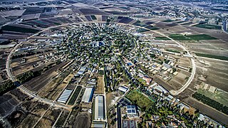
The Jezreel Valley, or Marj Ibn Amir, also known as the Valley of Megiddo, is a large fertile plain and inland valley in the Northern District of Israel. It is bordered to the north by the highlands of the Lower Galilee region, to the south by the Samarian highlands, to the west and northwest by the Mount Carmel range, and to the east by the Jordan Valley, with Mount Gilboa marking its southern extent. The largest settlement in the valley is the city of Afula, which lies near its center.

<span class="mw-page-title-main">Tulkarm</span> Municipality type A in State of Palestine

Tulkarm or Tulkarem is a Palestinian city in the West Bank, the capital of the Tulkarm Governorate of the State of Palestine. The Israeli city of Netanya is to the west, and the Palestinian cities of Nablus and Jenin to the east. According to the Palestinian Central Bureau of Statistics, in 2017 Tulkarm had a population of 64,532. Tulkarm is under the administration of the Palestinian National Authority.

<span class="mw-page-title-main">Yehoshua Hankin</span> Russian Zionist activist (1864 – 1945)

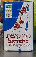
Yehoshua Hankin was a Zionist activist who was responsible for most of the major land purchases of the Zionist Organization in Ottoman Palestine and Mandatory Palestine – in particular for the Sursock Purchase.

<span class="mw-page-title-main">Nahalal</span> Place in northern Israel

Nahalal is a moshav in northern Israel. Covering 8.5 square kilometers (3.3 sq mi), it falls under the jurisdiction of the Jezreel Valley Regional Council. In 2022 it had a population of 1,351.

<span class="mw-page-title-main">Zir'in</span> Place in Jenin, Mandatory Palestine

Zir'in was a Palestinian Arab village of over 1,400 in the Jezreel Valley, located 11 kilometers (6.8 mi) north of Jenin. Identified as the ancient town of Yizre'el (Jezreel), it was known as Zir'in during Islamic rule, and was near the site of the Battle of Ain Jalut, in which the Mamluks halted Mongol expansion southward. Under the Ottomans, it was a small village, expanding during the British Mandate in the early 20th century. After its capture by Israel in 1948, Zir'in was destroyed. The Israeli kibbutz of Yizre'el was established shortly after on the village lands of Zir'in.

<span class="mw-page-title-main">Gesher, Israel</span> Place in Northern, Israel

Gesher is a kibbutz in the Beit She'an Valley in northeastern Israel. Founded in 1939 by Jewish refugees from Germany, it falls under the jurisdiction of Valley of Springs Regional Council. It is situated 10 km south of kibbutz Deganya Aleph and 15 km south of Tiberias. The population is approximately 500 inhabitants.

<span class="mw-page-title-main">Huj, Gaza</span> Place in Gaza, Mandatory Palestine

Huj was a Palestinian Arab village located 15 kilometers (9.3 mi) northeast of Gaza City. Identified as the site of the ancient Philistine town of Oga, the modern village was founded by the Ottomans in the early 19th century.

Land and property laws in Israel are the property law component of Israeli law, providing the legal framework for the ownership and other in rem rights towards all forms of property in Israel, including real estate (land) and movable property. Besides tangible property, economic rights are also usually treated as property, in addition to being covered by the law of obligations.

The Palestinian people are an ethnonational group with family origins in the region of Palestine. Since 1964, they have been referred to as Palestinians, but before that they were usually referred to as Palestinian Arabs. During the period of the British Mandate, the term Palestinian was also used to describe the Jewish community living in Palestine.

Jalqamus is a Palestinian village in the West Bank, located 10 km southeast of the city of Jenin in the northern West Bank. According to the Palestinian Central Bureau of Statistics, the town had a population of 1,867 inhabitants in mid-year 2006 and 2,624 by 2017.

<span class="mw-page-title-main">Alonim</span> Place in Northern, Israel

Alonim is a kibbutz in northern Israel. Located in the Lower Galilee, it falls under the jurisdiction of Jezreel Valley Regional Council. In 2022 the kibbutz had a population of 552.

<span class="mw-page-title-main">Naghnaghiya</span> Village in Haifa, Mandatory Palestine

Naghnaghiya was a Palestinian Arab village, 28.5 kilometers (17.7 mi) southeast of Haifa. It was depopulated before the outbreak of the 1948 Arab-Israeli war.

<span class="mw-page-title-main">Daliyat al-Rawha'</span> Village in Haifa, Mandatory Palestine

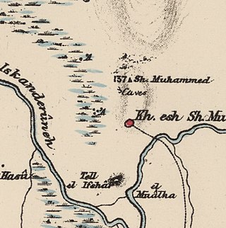
Daliyat al-Rawha' was a Palestinian village located 24.5 kilometers (15.2 mi) southeast of Haifa. It was the site of the signing of a ceasefire agreement between the forces of the Mamluks and the Crusaders in the 13th century. A small village of 60 Arab Muslims in the late 19th century, the kibbutz of Dalia was established on land purchased in the village in 1939. The population in 1945 reached 600 people: 280 Arabs and 320 Jews. It was depopulated of its Arab inhabitants in late March during the 1947–1948 civil war in Mandatory Palestine.

<span class="mw-page-title-main">Zarnuqa</span> Place in Ramle, Mandatory Palestine

Zarnuqa, also Zarnuga, was a Palestinian Arab village in the Ramle Subdistrict. It was depopulated on 27–28 May 1948 during the 1948 Arab–Israeli War.

<span class="mw-page-title-main">Wadi al-Hawarith</span> Camping site in Tulkarm, Mandatory Palestine

Wadi al-Hawarith was a Palestinian bedouin camping site in the Tulkarm Subdistrict. It was depopulated at the outbreak of the 1948 Arab–Israeli War on March 15, 1948, following the 1947–48 Civil War in Mandatory Palestine. It was located 16.5 km northwest of Tulkarm. Wadi al-Hawarith was mostly destroyed with the exception of four houses.

<span class="mw-page-title-main">Nuris</span> Place in Jenin, Mandatory Palestine

Nuris was a Palestinian Arab village in the District of Jenin. In 1945, Nuris had 570 inhabitants. It was depopulated during the 1948 War on 29 May 1948 under Operation Gideon. The Israeli moshav of Nurit was built on Nuris' village land in 1950.

<span class="mw-page-title-main">Mandatory Palestine</span> British League of Nations mandate (1920–1948)

Mandatory Palestine was a geopolitical entity that existed between 1920 and 1948 in the region of Palestine under the terms of the League of Nations Mandate for Palestine.

<span class="mw-page-title-main">Sursock Purchases</span> Largest Jewish land purchase in Palestine during the period of early Jewish immigration

The Sursock Purchases were land purchases made by Jewish organizations from the Greek Sursock family, mainly from 1901 to 1925. These included the Jezreel Valley and Haifa Bay, as well as other lands in what became the Mandate for Palestine. These collectively formed the largest Jewish land purchase in Palestine during the period of early Jewish immigration.

References

  1. A Survey of Palestine, Table 2 showing Holdings of Large Jewish Lands Owners as of December 31, 1945, British Mandate: A Survey of Palestine: Volume I - Page 245. Chapter VIII: Land: Section 3.
  2. Ilan Pappe (2022). A History of Modern Palestine. Cambridge University Press. ISBN   978-1-108-24416-9. The Zionist approach during the Mandate was to buy land from the big landlords and evict the tenants.
  3. "Palestine: Land ownership by sub-district (1945) - Map (1 August 1950)".
  4. {Village Statistics, April 1945
  5. Hadawi, Sami (1957) Land ownership in Palestine, p12
  6. Hallbrook 1981, p. 365,368.
  7. Ismail, Ahmad. "Palestine: Land ownership by sub-district (based on 1945 data) - Map - Ad Hoc Committee on the Palestine Question". Question of Palestine. Retrieved 3 May 2024.
  8. 1 2 3 Porath (1977), p. 80.
  9. Tubi, Omri (1 January 2021). "Kill me a mosquito and I will build a state: political economy and the socio-technicalities of Jewish colonization in Palestine, 1922–1940". Theory and Society. 50 (1): 97–124. doi:10.1007/s11186-020-09402-4. ISSN   1573-7853. S2CID   255013309.
  10. Isaac Herzog (1967). The Main Institutions of Jewish Law: The law of obligations. Soncino Press. p. 51.
  11. Zahavi, Yosef (1962). Eretz Israel in rabbinic lore (Midreshei Eretz Israel): an anthology. Tehilla Institute. p. 28. If one buys a house from a non-Jew in Eretz Israel, the title deed may be written for him even on the Sabbath. On the Sabbath!? Is that possible? But as Rava explained, he may order a non-Jew to write it, even though instructing a non-Jew to do a work prohibited to Jews on the Sabbath is forbidden by rabbinic ordination, the rabbis waived their decree on account of the settlement of Eretz Israel.
  12. 1 2 Kark, Ruth (1984). "Changing patterns of landownership in nineteenth-century Palestine: the European Influence". Journal of Historical Geography. 10 (4): 357–384. doi:10.1016/0305-7488(84)90069-0.
  13. 1 2 Jonathan R. Adelman (2008). The rise of Israel: a history of a revolutionary state. Taylor & Francis. p. 58. ISBN   978-0-415-77509-0.
  14. Ocak, Murat (2002). The Turks: Ottomans (2 v. ). Yeni Türkiye. ISBN   9789756782590. Even though the Ottoman government was disturbed by this decision, it was compelled to take it, in order to close all doors to the Jews in 1891 and to prohibit the sale of Palestinian land to Jews, even if they were Ottoman citizens, in 1892.
  15. 1 2 3 4 5 6 Porath (1977), p. 81.
  16. "Land Ownership in Palestine/Israel".
  17. Avneri, Aryeh L. (1982). The Claim of Dispossession: Jewish Land-Settlement and the Arabs, 1878-1948. Transaction Publishers. p. 117. ISBN   9781412836210. ... the High Commissioner promulgated an edict forbidding the sale of more than 300 dunams of land or the sale of land worth more than 3000 Palestinian Pounds (LP.), without his prior permission.
  18. Hallbrook 1981, p. 364.
  19. Table 2 showing Holdings of Large Jewish Lands Owners as of December 31st, 1945, British Mandate: A Survey of Palestine: Volume I - Page 245. Chapter VIII: Land: Section 3., prepared by the British Mandate for the United Nations Survey of Palestine Retrieved 4 July 2015
  20. Anglo-American Committee of Inquiry on Jewish Problems in Palestine and Europe, J. V. W. Shaw, General Assembly, Special Committee on Palestine, United Nations (1991). A Survey of Palestine: Prepared in December, 1945 and January, 1946 for the Information of the Anglo-American Committee of Inquiry. Vol. 1. Institute for Palestine Studies. ISBN   0-88728-211-3.{{cite book}}: CS1 maint: multiple names: authors list (link)
  21. Wright, Clifford A. (2015). Facts and Fables (RLE Israel and Palestine): The Arab-Israeli Conflict. Routledge. p. 38. ISBN   978-1-317-44775-7.
  22. "Report of the Palestine Royal Commission — July 1937". Jewish Virtual Library . Retrieved 31 October 2022.
  23. 1 2 3 Porath, pp. 87–88.

Bibliography