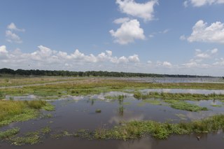
Lake Fork Reservoir is a reservoir located in Wood, Rains, and Hopkins counties in the state of Texas, between the towns of Quitman, Alba, Emory, and Yantis, Texas.

Lake Whitney is a flood control reservoir on the main stem of the Brazos River in Texas. It is located on River Mile Marker 442 and controls drainage for 17,656 square miles (45,730 km2) of Texas and parts of New Mexico. The reservoir encompasses a surface area of more than 23,500 acres and 225 miles (362 km) of shoreline. The area consists of rolling, tallgrass prairies; cedar trees; hardwood timber; and 100 ft (30 m) bluffs and rock points. Lake Whitney is also part of the Texas Lakes Trail Region of North Texas.
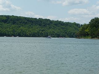
Taylorsville Lake is a 3,050-acre (1,230 ha) artificial lake or reservoir located mainly in Spencer County, Kentucky. As of 12/19/21 Taylorsville Lake has become a hotspot for migrating ducks. According to Central KY Waterfowlers the lake is currently holding a record number of waterfowl. It has been estimated over 20,000 ducks have been harvested in 3 days. Construction by the United States Army Corps of Engineers started in 1974, and flooding began in 1983. The total cost of the lake was $103 million. It is about 18.5 miles (29.8 km) long. Backwater areas of the lake are also located in Nelson County and Anderson County.

Jim Chapman Lake is a 19,305-acre (78.12 km2) impoundment operated by the Army Corps of Engineers and is located 75 miles (121 km) east of the Dallas/Fort Worth Metroplex in the state of Texas.

Cooper Lake State Park is a Texas State Park in Delta and Hopkins counties, about three miles (5 km) south of Cooper, Texas. The park is situated on Jim Chapman Lake, formerly known as Cooper Lake. There are actually two geographically separate units; the Doctors Creek unit 33°20′54″N95°40′08″W is located on the north side of the lake, in Delta County, while the South Sulphur unit 33°17′49″N95°39′35″W is located on the south side of the lake, in Hopkins County.

Wilson Lake is a reservoir in the U.S. state of Kansas, on the border of Russell County and Lincoln County. Built and managed by the U.S. Army Corps of Engineers for flood control, it is also used for wildlife management and recreation. Several parks are located along its shoreline, including Wilson State Park.

Perry Lake is a US Army Corps of Engineers operated reservoir in northeast Kansas. Its primary purposes are flood control, water reserve for nearby areas and regional recreation. The lake is approximately 11,150 acres (45 km²) in size, with over 160 miles (260 km) of shoreline. Perry Lake's full multi-purpose pool elevation is 891.5 feet (271.7 m) above sea level. Perry Lake is located about 40 miles (64 km) west of Kansas City, just northwest of Lawrence, Kansas. Its close proximity to Kansas City, Lawrence, and the state capitol, Topeka, make it a very popular destination, with the nickname "Paradise on the Plains".

Lake Waco is a man-made reservoir located on the west side of Waco, in McLennan County, Texas. It provides water to several cities in the Waco Metropolitan Statistical Area, including Waco, Bellmead, Hewitt, Robinson, Woodway and others in the Cross Timbers and Prairies ecoregion of Texas. Lake Waco was formed by a dam built on the Bosque River basin. The lake has 79,000 acre-feet (97,000,000 m3) of water and is managed by the U.S. Army Corps of Engineers.
The Sulphur River is a 175-mile-long (282 km) river in northeast Texas and southwest Arkansas in the United States.

Wright Patman Lake is a reservoir in northeast Texas in the United States. The lake is a U.S. Army Corps of Engineers reservoir formed on the Sulphur River in Bowie and Cass counties by Wright Patman Dam. The reservoir provides flood control and water conservation for the communities downstream from the dam. The lake is also a popular recreational destination. The Bowie County side of the lake is part of the Texarkana metropolitan area.
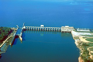
Lake Seminole is a reservoir located in the southwest corner of Georgia along its border with Florida, maintained by the U.S. Army Corps of Engineers. The Chattahoochee and Flint rivers join in the lake, before flowing from the Jim Woodruff Lock and Dam, which impounds the lake, as the Apalachicola River. The lake contains 37,500 acres (152 km2) of water, and has a shoreline of 376 mi (605 km). The fish in Lake Seminole include largemouth bass, crappie, chain pickerel, catfish, striped bass and other species. American alligators, snakes and various waterfowl are also present in the lake, which is known for its goose hunting.

Lavon Lake is a freshwater reservoir located in southeast Collin County, Texas, on the East Fork of the Trinity River near Wylie, off State Highway 78. It is commonly called Lake Lavon for commercial and recreational purposes, but Lavon Lake is its official name according to the U.S. Army Corps of Engineers. It was originally called Lavon Reservoir.

El Dorado Lake is a reservoir on the Walnut River 0.5 miles (0.80 km) northeast of El Dorado in the Flint Hills region of Kansas. Built and managed by the U.S. Army Corps of Engineers, it is used for flood control, recreation, and water supply. El Dorado State Park is located on its shore.
Grapevine Lake is a reservoir located in the North Texas region, about 20 mi (32 km) northwest of Dallas and northeast of Fort Worth. It was impounded in 1952 by the US Army Corps of Engineers when they dammed Denton Creek, a tributary of Trinity River.

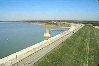
Hugo Lake is manmade lake located 7 miles (11 km) east of Hugo, in Choctaw County, Oklahoma, United States. It is formed by Hugo Lake Dam on the Kiamichi River 18 miles (29 km) upstream from the Red River. The dam is visible from U.S. Route 70, which crosses its spillway just west of Sawyer. Lake Hugo features approximately 110 miles (180 km) of shoreline and covers over 13,250 acres (53.6 km2), or 20 square miles (52 km2). Its normal pool elevation is 404.5 feet (123.3 m) above sea level and its normal storage capacity is 157,600 acre-feet (194,400,000 m3). At flood stage its elevation is at 437.5 feet (133.4 m) above sea level and it is capable of storing 966,700 acre-feet (1.1924×10⁹ m3) of flood waters. The lake's primary functions are to provide flood control, water storage, and recreational opportunities.

John Redmond Reservoir is a reservoir on the Neosho River in eastern Kansas. Built and managed by the U.S. Army Corps of Engineers, it is used for flood control, recreation, water supply, and wildlife management. It borders the Flint Hills National Wildlife Refuge to the northwest.

Kanopolis Lake is a reservoir in Ellsworth County in the Smoky Hills of central Kansas, about 31 miles southwest of Salina and a few miles southeast of the town of Kanopolis. The lake is formed by Kanopolis Dam. Completed in 1948 as a flood control and water conservation project of the United States Army Corps of Engineers, the dam impounds the Smoky Hill River.

Council Grove Lake is a reservoir on the Neosho River in east-central Kansas. Built and managed by the U.S. Army Corps of Engineers, it is used for flood control, recreation, and water supply.
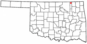
Copan Dam is a dam in Washington County, Oklahoma, in the northeastern part of the state.

Townshend Dam is a dam in Townshend, Windham County, Vermont.
