
Wadena County is a county in the U.S. state of Minnesota. As of the 2020 census, the population was 14,065. Its county seat is Wadena.

Cook County is the easternmost county in the U.S. state of Minnesota. As of the 2020 census, the population was 5,600, making it Minnesota's seventh-least populous county. Its county seat is Grand Marais. The Grand Portage Indian Reservation is in the county.

The Pigeon River forms part of the Canada–United States border between the state of Minnesota and the province of Ontario, west of Lake Superior. In pre-industrial times, the river was a waterway of great importance for transportation and the fur trade.

Eagle Mountain is the highest natural point in Minnesota, United States, at 2,301 feet (701 m). It is in northern Cook County in the Boundary Waters Canoe Area Wilderness and Superior National Forest in the Misquah Hills, northwest of Grand Marais. It is a Minnesota State Historic Site.
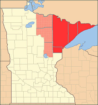
The Arrowhead Region is located in the northeastern part of the U.S. state of Minnesota, so called because of its pointed shape. The predominantly rural region encompasses 10,635.26 square miles (27,545.2 km2) of land area and includes Carlton, Cook, Lake and Saint Louis counties. Its population at the 2000 census was 248,425 residents. The region is loosely defined, and Aitkin, Itasca, and Koochiching counties are sometimes considered as part of the region, increasing the land area to 18,221.97 square miles (47,194.7 km2) and the population to 322,073 residents. Primary industries in the region include tourism and iron mining.
Fairbanks is an unincorporated community in Fairbanks Township, Saint Louis County, Minnesota, United States; located within the Superior National Forest.
Greaney is an unincorporated community in Saint Louis County, Minnesota, United States. Greaney is located within ZIP code 55771, based in Orr.
Ash Lake is an unincorporated community in Saint Louis County, Minnesota, United States; located within the Kabetogama State Forest.
Cusson is an unincorporated community in Leiding Township, Saint Louis County, Minnesota, United States; located in the Arrowhead Region of Minnesota.

Buyck is an unincorporated community in Portage Township, Saint Louis County, Minnesota, United States.
Little Marais is an unincorporated community in Lake County, Minnesota, United States; located on the North Shore of Lake Superior.

Tofte is an unincorporated community in Tofte Township, Cook County, Minnesota, United States.

Schroeder is an unincorporated community in Schroeder Township, Cook County, Minnesota, United States.
Ray is an unincorporated community in Koochiching County, Minnesota, United States.

The Caribou River is a 15.0-mile-long (24.1 km) river in northern Minnesota, the United States. It rises in a swamp about .6 miles (1 km) south of Morris Lake and two miles (3.2 km) east of Echo Lake, near the Lake/Cook County line, at an altitude about 1620 feet above sea level. It descends some 1,020 feet in elevation as it flows south to its mouth at Lake Superior, also near the eastern border of Lake County.
Nett Lake is an unincorporated community and census-designated place (CDP) in Nett Lake Territory, Saint Louis County, Minnesota, United States; located on the shore of Nett Lake. As of the 2020 census, its population was 230.
Gheen is an unincorporated community in Gheen Territory, Saint Louis County, Minnesota, United States, one mile (1.6 km) east of Gheen Corner on Willow River Road.
Island Lake is an unincorporated community in Beltrami County, in the U.S. state of Minnesota.
Christine Lake is a lake in Cook County, Minnesota, in the United States.
Wall Lake is an unincorporated community in Otter Tail County, in the U.S. state of Minnesota.
