John Augustine Edgell

Last updated

Sir John Edgell
SeaSurveys Edgell 1965 0023 06 John Augustine Edgell.jpg
Born(1880-12-20)20 December 1880
Teddington, Middlesex
Died14 November 1962(1962-11-14) (aged 81)
AllegianceUnited Kingdom
Service/branch Royal Navy
Years of service1893-1945
Rank Vice-admiral
Office Hydrographer of the Navy
Term1932-1945

Vice-Admiral Sir John Augustine Edgell, KBE, CB, FRS (20 December 1880 - 14 November 1962) was an officer in the Royal Navy and Hydrographer of the Navy from 1932 to 1945. He was noted for his support for innovations such as echo sounding and radio navigation, for the surveying and chart production operations of his department during World War II, and for his advocacy of the science of oceanography

Contents

Early life to 1914

Admiralty Chart of Johore Strait, surveyed by Edgell in 1921 Admiralty Chart No 2586 Eastern Portion of Johore Strait (Singapore Old Strait) Pulo Ubin to Sungi Kranji, Published 1924.jpg
Admiralty Chart of Johore Strait, surveyed by Edgell in 1921

Edgell was born at Teddington to James and Mary Beatrice Edgell. He joined the Navy aged 13, first on the cadet training ship HMS Britannia, and then on HMS Blenheim. He was promoted to midshipman in June 1897. He joined the surveying service in 1902 as a sub-lieutenant on HMS Triton in the North Sea. [1] [2] [3] :92–93 He was promoted to Lieutenant in 1903, [4] and then served on HMS Egeria in British Columbia and HMS Rambler in China and Borneo. He took a course on magnetic observations in 1906, and then continued survey work on HMS Merlin in the Red Sea, Malaya and Borneo, and on HMS Sealark in the Indian Ocean and south-west Pacific. His first command was HMS Mutine surveying on the west coast of Africa from 1912 to 1914. He then surveyed the east coast of Scotland and the Shetland Islands in HMS Hearty. [3] :92–93

World War I to 1931

In September 1915, having been promoted to Commander, Edgell took HMS Endeavour to the eastern Mediterranean in support of the Dardanelles operation. The ship carried printing presses so the charts prepared from her surveying work could be provided to the fleet without the need to be returned to England for printing. [3] :21 Edgell then became Superintendent of Charts, from 1917 to 1920. In 1921 he was again at sea, surveying in Singapore on HMS Merlin. He was promoted to captain in 1923, and again became Superintendent of Charts, from 1923 to 1925. His next surveying assignment was in Australia, commanding HMAS Moresby until 1928. He was Assistant Hydrographer from 1928 to 1932, interrupted by a surveying assignment on HMS Endeavour in the Red Sea in 1930–1931. [3] :92–93

Hydrographer: 1932-1939

Edgell became Hydrographer in October 1932, and would hold this position until the end of World War II. He was promoted to rear admiral in 1935, and to vice admiral in 1938, officially retiring at that point. However he continued in post until 1945. During his time as Hydrographer he oversaw many technical innovations, including the development of echo sounding for deep water work, and the change from flat-bed to rotary offset printing, the latter facilitated by the move of the Chart Printing Establishment to Taunton. He also planned the introduction of a new generation of surveying ships. These developments greatly increased productivity, and laid the basis for the enormous expansion of surveying and chart production needed during the war. [3] :92–93 Edgell developed his interest in the scientific aspects of surveying during this time, publishing a number of papers on surveying methods, and actively promoting research in oceanography. One project was the construction of a non-magnetic vessel specifically for research into magnetic fields. Construction of the Royal Research Ship (R.R.S.) Research was started in 1937, but interrupted on the outbreak and war, and never restarted. [3] :78 [2]

World War II

During the war, the nature of surveying changed. Minefields had to be cleared, and safe passages marked with buoys. Wrecks had to be surveyed, marked and charted. Damaged harbours had to be re-surveyed. Perhaps the most important work was surveying of coastal areas in preparation for landings, the largest being Operation Neptune on the Normandy coast in 1944. Clandestine surveys were carried out at night on the beaches prior to the planned landings, including shore parties taking samples of the sand. New charts were prepared, incorporating the new material, and also adding in land as well as sea data. During the actual landings, survey boats worked continuously, buoying channels and obstructions. As the invasion developed, they were deployed to survey the harbours of Cherbourg and St Malo when these were taken. [3] :123–128 Chart production and distribution also faced challenges. Production was greatly increased, and measures were taken to protect the original plates of the charts, and to provide backups. [3] :116–117

Later life: Scientific advisory work and honours

Edgell was elected a Fellow of the Royal Society in 1943. In 1944, at a meeting of the Scientific Advisory Committee to the War Cabinet, he suggested that a national oceanographic laboratory should be established in the United Kingdom. Much work had been done in the field in the first half of the 20th-century, but there were no permanent institutions to support this work. The idea bore fruit in 1949, when the National Institute of Oceanography was established under the direction of Dr G.E.R. Deacon. [5] [6] Edgell served on the executive committee of the institute, and on the National Geographic Council. [3] :92–93

Edgell was created K.B.E in 1942. He was the Admiralty's representative on the Boards of the Port of London Authority (1941-1950) and the Kent River Board, and acting conservator of the River Mersey (1945-1950). He died on 14 November 1962. [1]

Related Research Articles

<span class="mw-page-title-main">Francis Beaufort</span> Irish hydrographer

Sir Francis Beaufort was an Irish hydrographer, creator of the Beaufort cipher and the Beaufort scale, and naval officer.

A hydrographic office is an organization which is devoted to acquiring and publishing hydrographic information.

<span class="mw-page-title-main">United Kingdom Hydrographic Office</span> UK government agency concerned with providing hydrographic and marine geospatial data

The United Kingdom Hydrographic Office (UKHO) is the UK's agency for providing hydrographic and marine geospatial data to mariners and maritime organisations across the world. The UKHO is a trading fund of the Ministry of Defence (MoD) and is located in Taunton, Somerset, with a workforce of approximately 900 staff.

<span class="mw-page-title-main">Research vessel</span> Ship or boat designed, modified, or equipped to carry out research at sea

A research vessel is a ship or boat designed, modified, or equipped to carry out research at sea. Research vessels carry out a number of roles. Some of these roles can be combined into a single vessel but others require a dedicated vessel. Due to the demanding nature of the work, research vessels may be constructed around an icebreaker hull, allowing them to operate in polar waters.

<span class="mw-page-title-main">Admiralty chart</span> Nautical chart

Admiralty charts are nautical charts issued by the United Kingdom Hydrographic Office (UKHO) and subject to Crown Copyright. Over 3,500 Standard Nautical Charts (SNCs) and 14,000 Electronic Navigational Charts (ENCs) are available with the Admiralty portfolio offering the widest official coverage of international shipping routes and ports, in varying detail.

The Naval Oceanographic Office (NAVOCEANO), located at John C. Stennis Space Center in south Mississippi, comprises approximately 1,000 civilian, military and contract personnel responsible for providing oceanographic products and services to all elements within the Department of Defense.

<span class="mw-page-title-main">Thomas Henry Tizard</span> English naval officer and oceanographer (1839–1924)

Thomas Henry Tizard was an English oceanographer, hydrographic surveyor, and navigator.

Rear-Admiral Sir David William Haslam was a Royal Navy officer.

Rear-Admiral George Stephen Ritchie CB DSC was a British admiral noted for his cartographic and hydrographic work.

<span class="mw-page-title-main">Frederick Evans (hydrographer)</span> Officer of the Royal Navy and hydrographer

Sir Frederick John Owen Evans, was an officer of the Royal Navy. He became a distinguished hydrographer during his career and served as Hydrographer of the Navy.

<span class="mw-page-title-main">John Washington (Royal Navy officer)</span> English naval officer and hydrographer

John Washington was an officer of the Royal Navy, Hydrographer of the Navy, and a founding member of the Royal Geographical Society of London.

<span class="mw-page-title-main">Russian Hydrographic Service</span>

The Russian Hydrographic Service, full current official name Department of Navigation and Oceanography of the Ministry of Defence of the Russian Federation, is Russia's hydrographic office, with responsibility to facilitate navigation, performing hydrographic surveys and publishing nautical charts.

<span class="mw-page-title-main">Arthur Mostyn Field</span>

Admiral Sir Arthur Mostyn Field, was a senior officer in the Royal Navy who served as Hydrographer of the Navy from 1904 to 1909.

Noel Atherton was a British cartographer in the Admiralty Hydrographic Office; today known as the United Kingdom Hydrographic Office. Chief Civil Hydrographic Officer and Assistant Superintendent of Charts, for the Admiralty between 1951 and 1962.

<span class="mw-page-title-main">Herbert Purey-Cust</span>

Sir Herbert Edward Purey-Cust, KBE, CB was an officer in the Royal Navy and Hydrographer of the Navy from 1909 to 1914.

<span class="mw-page-title-main">Charles Gepp Robinson</span> British Royal Navy officer and hydrographic surveyor (1805–1875)

Charles Gepp Robinson was a Royal Navy Officer and hydrographic surveyor particularly noted for his survey work in the west of Scotland.

<span class="mw-page-title-main">Archibald Day</span> Royal Navy (UK) officer and Hydrographer to the Navy

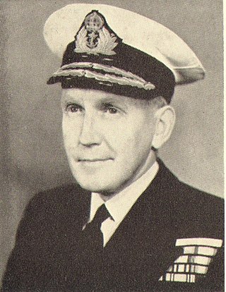
Vice-Admiral Sir Archibald Day, was an officer in the Royal Navy and Hydrographer of the Navy from 1950-1955. He played an important part in planning the evacuation from Dunkirk in 1940, and wrote a history of the Hydrographic Service.

<span class="mw-page-title-main">Frederick Bullock (Royal Navy officer)</span>

Admiral Frederick Bullock was a Royal Navy officer noted for his work as a surveyor, particularly in the Thames Estuary.

<span class="mw-page-title-main">John Edward Davis (Royal Navy officer)</span>

John Edward Davis (1815-1877) was a Royal Navy officer, hydrographic surveyor and artist, noted for his illustrations of the Antarctic voyage of James Clark Ross (1839-1843) and for his expertise in deep-sea sounding.

<span class="mw-page-title-main">Arthur Guy Norris Wyatt</span>

Arthur Guy Norris Wyatt (1893-1982), often known as Guy Wyatt, was a Royal Navy Officer and Surveyor who was Hydrographer of the Navy in 1945–1950.

References

  1. 1 2 Irving, E.G. (1962). "Sir John Edgell, K.B.E., C.B., F.R.S". Nature. 196 (4861): 1266–1277. Bibcode:1962Natur.196.1266I. doi: 10.1038/1961266a0 . S2CID   4220017.
  2. 1 2 Deacon, George Edward Raven (1963). "John Augustine Edgell, 1880-1962". Biographical Memoirs of Fellows of the Royal Society. 9: 87–90. doi:10.1098/rsbm.1963.0005. S2CID   71264279.
  3. 1 2 3 4 5 6 7 8 9 Morris, Roger O. (1995). Charts and Surveys in Peace and War: The History of the Royal Navy's Hydrographic Service, 1919-1970. H.M. Stationery Office. ISBN   978-0-11-772456-3. OCLC   1173816600.
  4. "John Augustine Edgell". The Dreadnought Project. Retrieved 8 October 2021.
  5. Deacon, G. E. R. (July 1954). "The National Institute of Oceanography". Journal of Navigation. 7 (3): 252–261. doi:10.1017/S0373463300020919. eISSN   1469-7785. ISSN   0373-4633. S2CID   30830137.
  6. Affholder, M.; Valiron, F. (1 January 2001). Descriptive Physical Oceanography. CRC Press. pp. 36–37. ISBN   978-0-203-96927-4.

Bibliography