
HMS Beagle was a Cherokee-class 10-gun brig-sloop of the Royal Navy, one of more than 100 ships of this class. The vessel, constructed at a cost of £7,803, was launched on 11 May 1820 from the Woolwich Dockyard on the River Thames. Later reports say the ship took part in celebrations of the coronation of King George IV of the United Kingdom, passing under the old London Bridge, and was the first rigged man-of-war afloat upriver of the bridge. There was no immediate need for Beagle, so she "lay in ordinary", moored afloat but without masts or rigging. She was then adapted as a survey barque and took part in three survey expeditions.

Sir Francis Beaufort was an Irish hydrographer, creator of the Beaufort cipher and the Beaufort scale, and naval officer.

HMS Erebus was a Hecla-class bomb vessel constructed by the Royal Navy in Pembroke dockyard, Wales, in 1826. The vessel was the second in the Royal Navy named after Erebus, the personification of darkness in Greek mythology.

The United Kingdom Hydrographic Office (UKHO) is the UK's agency for providing hydrographic and marine geospatial data to mariners and maritime organisations across the world. The UKHO is a trading fund of the Ministry of Defence (MoD) and is located in Taunton, Somerset, with a workforce of approximately 900 staff.

The Hecla class was a class of bomb vessels of the Royal Navy of the early 19th century. They were designed for use as bomb or mortar ships and were very heavily built. Eight ships were launched; all were converted for use as exploration or survey ships. Four ships of the class are known for the role they played in Arctic and Antarctic exploration.

Admiralty charts are nautical charts issued by the United Kingdom Hydrographic Office (UKHO) and subject to Crown Copyright. Over 3,500 Standard Nautical Charts (SNCs) and 14,000 Electronic Navigational Charts (ENCs) are available with the Admiralty portfolio offering the widest official coverage of international shipping routes and ports, in varying detail.

HMS Terror was a specialised warship and a newly developed bomb vessel constructed for the Royal Navy in 1813. She participated in several battles of the War of 1812, including the Battle of Baltimore with the bombardment of Fort McHenry. She was converted into a polar exploration ship two decades later, and participated in George Back's Arctic expedition of 1836–1837, the successful Ross expedition to the Antarctic of 1839 to 1843, and Sir John Franklin's ill-fated attempt to force the Northwest Passage in 1845, during which she was lost with all hands along with HMS Erebus.
Francis Rawdon Moira Crozier was an Irish officer of the Royal Navy and polar explorer who participated in six expeditions to the Arctic and Antarctic. In May 1845, he was second-in-command to Sir John Franklin and captain of HMS Terror during the Franklin expedition to discover the Northwest Passage, which ended with the loss of all 129 crewmen in mysterious circumstances.

Cockburn Island is an oval island 2.7 kilometres (1.7 mi) long, consisting of a high plateau with steep slopes surmounted on the northwest side by a pyramidal peak 450 m (1,476 ft) high, lying in the north-east entrance to Admiralty Sound, south of the north-east end of the Antarctic Peninsula. It was discovered by a British expedition (1839–43) led by Captain James Clark Ross, who named it for Admiral Sir George Cockburn, then serving as First Naval Lord.

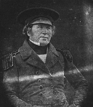
Sir James Clark Ross was a British Royal Navy officer and polar explorer known for his explorations of the Arctic, participating in two expeditions led by his uncle John Ross, and four led by William Edward Parry, and, in particular, for his own Antarctic expedition from 1839 to 1843.

Vice-Admiral Archibald McMurdo was a Scottish naval officer and polar explorer after whom Antarctica's McMurdo Sound, McMurdo Station, McMurdo Ice Shelf, McMurdo Dry Valleys and McMurdo–South Pole Highway are named.
Thomas Henry Tizard was an English oceanographer, hydrographic surveyor, and navigator.
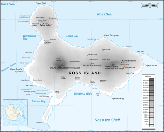
Cape Crozier is the most easterly point of Ross Island in Antarctica. It was discovered in 1841 during James Clark Ross's expedition of 1839 to 1843 with HMS Erebus and HMS Terror, and was named after Francis Crozier, captain of HMS Terror. The extinct volcano Mount Terror, also named during the Ross expedition, rises sharply from the Cape to a height of 3,230 m (10,600 ft), and the edge of the Ross Ice Shelf stretches away to its east.

The era of European and American voyages of scientific exploration followed the Age of Discovery and were inspired by a new confidence in science and reason that arose in the Age of Enlightenment. Maritime expeditions in the Age of Discovery were a means of expanding colonial empires, establishing new trade routes and extending diplomatic and trade relations to new territories, but with the Enlightenment scientific curiosity became a new motive for exploration to add to the commercial and political ambitions of the past. See also List of Arctic expeditions and List of Antarctic expeditions.

The Flora Antarctica, or formally and correctly The Botany of the Antarctic Voyage of H.M. Discovery Ships Erebus and Terror in the years 1839–1843, under the Command of Captain Sir James Clark Ross, is a description of the many plants discovered on the Ross expedition, which visited islands off the coast of the Antarctic continent, with a summary of the expedition itself, written by the British botanist Joseph Dalton Hooker and published in parts between 1844 and 1859 by Reeve Brothers in London. Hooker sailed on HMS Erebus as assistant surgeon.

The Ross expedition was a voyage of scientific exploration of the Antarctic in 1839 to 1843, led by James Clark Ross, with two unusually strong warships, HMS Erebus and HMS Terror. It explored what is now called the Ross Sea and discovered the Ross Ice Shelf. On the expedition, Ross discovered the Transantarctic Mountains and the volcanoes Mount Erebus and Mount Terror, named after each ship. The young botanist Joseph Dalton Hooker made his name on the expedition.

Thomas Abernethy was a Scottish seafarer, gunner in the Royal Navy, and polar explorer. Because he was neither an officer nor a gentleman, he was little mentioned in the books written by the leaders of the expeditions he went on, but was praised in what was written. In 1857, he was awarded the Arctic Medal for his service as an able seaman on the 1824–25 voyage of HMS Hecla, the first of his five expeditions for which participants were eligible for the award. He was in parties that, for their time, reached the furthest north, the furthest south (twice), and the nearest to the South Magnetic Pole. In 1831, along with James Clark Ross's team of six, Abernethy was in the first party ever to reach the North Magnetic Pole.

Anisotome antipoda is a species of flowering plant in the family Apiaceae, which is endemic to the Auckland, Campbell and Antipodes Islands.

Edward Killwick Calver was a Captain in the Royal Navy, and hydrographic surveyor. He is particularly noted for his surveying work in the east of Britain, and as the captain of HMS Porcupine, in oceanographic voyages in 1869 and 1870.

Richard Hoskyn (1811-1873) was a Royal Navy officer and hydrographic surveyor. He discovered the site of Ancient Kaunos in what is now southern Turkey, surveyed much of the coast of Ireland, carried out deep-sea sounding in preparation for the laying of telegraphic cables, and became superintendent of charts for the UK Admiralty.
 Collision of Erebus and Terror
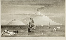 Beaufort Island and Mount Erebus
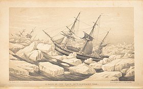 A Gale in the Pack


