Johnsons Landing, British Columbia

Last updated
Johnsons Landing
Unincorporated Community
Canada British Columbia location map 2.svg
Red pog.svg
Johnsons Landing
Location of Johnsons Landing in British Columbia
Coordinates: 50°04′59″N116°53′03″W / 50.08306°N 116.88417°W / 50.08306; -116.88417 Coordinates: 50°04′59″N116°53′03″W / 50.08306°N 116.88417°W / 50.08306; -116.88417
CountryFlag of Canada (Pantone).svg  Canada
Province Flag of British Columbia.svg  British Columbia
Region West Kootenay
Regional district Central Kootenay
Time zone UTC-7 (MST)
Area code(s) 250, 778, 236, & 672
Waterways Kootenay Lake
Gar Creek

Johnsons Landing is an unincorporated community in the West Kootenay region of southeastern British Columbia. The former steamboat landing comprises scattered rural properties adjacent to the mouth of Gar Creek. To the north is Gardner Creek and to the south is Fry Creek, the three creek mouths on the northeast shore of Kootenay Lake. [1] The locality, via BC Highway 31 and Argenta Rd, is about 121 kilometres (75 mi) northeast of Nelson.

Contents

Name origins

The earliest newspaper mention of Johnsons Landing is April 1911, and the census in that year recorded Swedish immigrant Algot Johnson and Robert McKinney as the only residents. However, May 1911 and April 1912 newspaper references placed Johnson at Fry Creek, then regarded as a separate locality. [2]

Fry Creek, likely named for prospector, trapper, and entrepreneur Richard Amherst Fry, is first mentioned regarding the Fry River in 1889, which was demoted to a creek by 1891. The earliest newspaper mention of that settlement was April 1911, and the census in that year recorded a population of 12, 10 of whom were a road building gang. Consequently, it is not unusual for a newspaper to adopt the more established name for the general area when defining Johnson's residence. [3] In 1906, Johnson is believed to have built the first house at Johnsons Landing. [4]

During the early 1910s, Fry Creek Gardens was one of the questionable Kootenay Lake orchard developments promoted by Fred (Honeymoon) Harris. [5] The Fry Creek steamboat landing operated at least until 1923. The 1921 census included Fry Creek as part of the more significant Johnsons Landing. [3]

Walter James Gardner bought 81 hectares (200 acres) at Gardner Creek before 1909. Gardners Landing recorded a population of five in the 1911 census, but the Gardner household was not present at that time. Gardiner Landing was the spelling used for the steamboat landing operating at least between 1913 and 1918. By that time, residents were included under Johnsons Landing in the civic directory, as was the Gardner household in the 1921 census. [3]

Early community

Arthur C. Raper was the inaugural Johnsons Landing postmaster 1917–1949. [6] The locality was known for its apple orchards. [7] In 1928, a telephone line was installed to Lardeau. [8] The next year, the wharf was replaced. [9]

The final year the steamboat flag stop existed was 1949. [10] A general store operated from the late 1940s at least into the mid-1950s. [11] [12]

The population, which was largely farmers, was about 20 by 1918, [13] 35 by 1927, [14] 48 by 1934, [15] 30 by 1943, [16] 32 by 1948, [11] and 27 by 1953. [12]

During 1953, the 3.7-metre (12 ft) wide Argenta–Johnsons Landing road was constructed, following the forestry trail. [17]

The back-to-the-land movement began during the late 1960s, with the arrival of hippies, US draft dodgers, and deserters. During 1966–1967, work on the Duncan Dam construction provided additional income that assisted these new farming ventures. [18]

The post office closed in 1970. [2]

Later community

A small community hall serves local needs and the Johnsons Landing Retreat Centre caters to visitors. Fry Creek Canyon offers hiking. [19]

In a community of about 35 permanent residents, a landslide down Gar Creek on July 12, 2012 failed to negotiate a sharp bend, climbed a ridge and spread out. The debris killed four people, decimated five houses, took out the road, and destroyed much of the water supply infrastructure. A report from the regional government in 2013 determined the slide was caused by a late snow melt and heavy rain. [4] [20] A second slide the following day narrowly missed emergency responders, residents and journalists. Two years after the landslide, the last of the evacuated residents were allowed to return to their homes. [21]

Between Johnsons Landing and Argenta, a 32.5-hectare (80-acre) subdivision called Bulmer's Pointe has been created, comprising 25 lakeside lots and eight wilderness lots. [22]

Johnsons Landing was one of the communities benefitting from a fibre-optic cable installed deep in Kootenay Lake in 2019 by the Kaslo infoNet Society. [23]

Related Research Articles

Rogers Pass (British Columbia) Mountain pass in British Columbia, Canada

Rogers Pass is a high mountain pass through the Selkirk Mountains of British Columbia, but the term also includes the approaches used by the Canadian Pacific Railway (CP) and the Trans-Canada Highway. In the heart of Glacier National Park, this tourism destination since 1886 is a National Historic Site.

Eholt is in the Boundary Country region of south central British Columbia. This ghost town, on BC Highway 3, is by road about 27 kilometres (17 mi) northwest of Grand Forks and 14 kilometres (9 mi) northeast of Greenwood.

Holberg, British Columbia Place in British Columbia, Canada

Holberg is a former ferry terminal about 35 kilometres (22 mi) from the northwest tip of Vancouver Island, British Columbia. This unincorporated community is at the head of Holberg Inlet, which forms the western arm of Quatsino Sound.

Silverton, British Columbia Village in British Columbia, Canada

Silverton is a village about 5 kilometres (3 mi) south of New Denver in the West Kootenay region of southeastern British Columbia. The former steamboat landing is at the mouth of Silverton Creek on the eastern shore of Slocan Lake. The locality, on BC Highway 6 at the junction of BC Highway 31A, is about 95 kilometres (59 mi) by road north of Castlegar and 155 kilometres (96 mi) by road and ferry south of Revelstoke.

Winlaw Place in British Columbia, Canada

Winlaw is an unincorporated community adjacent to Winlaw Creek on the east side of the Slocan River in the West Kootenay region of southeastern British Columbia. The locality is on BC Highway 6 about 20 kilometres (12 mi) south of Slocan, and 49 kilometres (30 mi) north of Castlegar.

Brookmere Locality in British Columbia, Canada

Brookmere is an unincorporated community adjacent to Brook Creek in the Nicola region of southern British Columbia. The former railway town, on Coldwater Rd, is by road about 44 kilometres (27 mi) south of Merritt.

Glacier, British Columbia

Glacier, which once comprised small communities, is on the western approach to Rogers Pass in southeastern British Columbia. The name derives from the Great Glacier, which in the 1880s was just over a mile from the original train station.

Albert Canyon Railway point in British Columbia, Canada

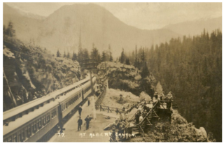
Albert Canyon is about 32 kilometres (20 mi) east of Revelstoke in southeastern British Columbia. The former community no longer exists, but the Canyon Hot Springs Resort borders to its north, both immediately southwest of the Tangier River confluence with the Illecillewaet River.

Cody is at the confluence of Cody Creek into Carpenter Creek in the West Kootenay region of southeastern British Columbia. The ghost town, about one kilometre east of Sandon, lies off BC Highway 31A. By road, the former mining community is about 15 kilometres (9 mi) east of New Denver and 44 kilometres (27 mi) west of Kaslo.

Trout Lake, British Columbia Place in British Columbia, Canada

Trout Lake is an unincorporated community in the West Kootenay region of southeastern British Columbia. The former steamboat landing is at the north end of Trout Lake. The locality, on BC Highway 31, is by road about 177 kilometres (110 mi) north of Nelson and 90 kilometres (56 mi) by road and ferry southeast of Revelstoke.

Rosebery, British Columbia Place in British Columbia, Canada

Rosebery is an unincorporated community about 6 kilometres (4 mi) north of New Denver in the West Kootenay region of southeastern British Columbia. The former steamboat landing and ferry terminal is at the mouth of Wilson Creek on the eastern shore of Slocan Lake. The locality, on BC Highway 6, is about 106 kilometres (66 mi) by road north of Castlegar and 144 kilometres (89 mi) by road and ferry south of Revelstoke.

Wynndel Unincorporated Community in British Columbia, Canada

Wynndel is an unincorporated community adjacent to Duck Creek, east of the Kootenay River, in the West Kootenay region of southeastern British Columbia. The locality, on BC Highway 3A, is by road about 11 kilometres (7 mi) north of Creston and 128 kilometres (80 mi) southeast of Nelson.

Thrums unincorporated community in British Columbia, Canada

Thrums is an unincorporated community on the northwest shore of the Kootenay River in the West Kootenay region of southeastern British Columbia. The location, on BC Highway 3A, is by road about 11 kilometres (7 mi) northeast of Castlegar, and 33 kilometres (21 mi) southwest of Nelson.

Vallican Place in British Columbia, Canada

Vallican is an unincorporated community on the west side of the Slocan River in the West Kootenay region of southeastern British Columbia. At the mouth of the Little Slocan River, the locality formerly spanned both sides of the Slocan River. The rural neighbourhood is off BC Highway 6 about 30 kilometres (19 mi) south of Slocan, and 39 kilometres (24 mi) north of Castlegar.

Edgewood, British Columbia Place in British Columbia, Canada

Edgewood is a settlement on the west shore of Lower Arrow Lake in the West Kootenay region of southeastern British Columbia. The former steamboat landing is between the mouths of Inonoaklin Creek and Eagle Creek. The locality, off BC Highway 6, is by road about 136 kilometres (85 mi) southeast of Vernon and 76 kilometres (47 mi) by road and ferry southwest of Nakusp.

Three Forks, British Columbia Place in British Columbia, Canada

Three Forks is a ghost town at the junction of Carpenter, Seaton, and Kane creeks in the West Kootenay region of southeastern British Columbia. This former mining community, on BC Highway 31A, is by road about 8 kilometres (5 mi) east of New Denver and 38 kilometres (24 mi) west of Kaslo.

Shushartie is a ghost town on the east shore of Shushartie Bay near the northeastern extremity of Vancouver Island, British Columbia.

Kildonan is an unincorporated community in the Alberni Inlet-Barkley Sound region of the west coast of southern Vancouver Island, British Columbia. The former steamboat landing and ferry dock is on the east shore of Uchuchklesit Inlet, which branches northwest of the lower reaches of Alberni Inlet. Adjacent to Pacific Rim National Park Reserve, the locality is by road and ferry about 120 kilometres (75 mi) southwest of Port Alberni.

South Slocan is an unincorporated community on the northwest shore of the Kootenay River in the West Kootenay region of southeastern British Columbia. The village, which comprises 51 households, provides a very small tax base. Over the years the population has fluctuated between 50 and 175 people. A former railway junction on BC Highway 6, it is approximately 24 kilometres (15 mi) northeast of Castlegar, and 20 kilometres (12 mi) southwest of Nelson. Its postal category is Rural Route One.

Beavermouth (railway point), British Columbia Railway point in British Columbia, Canada

Beavermouth is about 43 kilometres (27 mi) west of Golden, and about 32 kilometres (20 mi) east of the mid-point of the Connaught Tunnel beneath Rogers Pass, in southeastern British Columbia. At the mouth of the Beaver River, the train station was called Beavermouth, but the adjacent community, which no longer exists, was known as Beaver or Beaver Mouth. Nowadays, the closest road access is to the nearby Kinbasket Lake Resort.

References

  1. "Johnsons Landing (community)". BC Geographical Names .
    "Gar Creek (creek)". BC Geographical Names .
    "Gardner Creek (creek)". BC Geographical Names .
    "Fry Creek (creek)". BC Geographical Names .
  2. 1 2 "Nelson Star, 27 Apr 2015". www.nelsonstar.com.
  3. 1 2 3 "Castlegar News, 5 Apr 2018". www.castlegarnews.com.
  4. 1 2 "Tyee, 27 Jul 2012". www.thetyee.ca.
  5. "Trail Times, 19 Aug 2018". www.trailtimes.ca.
  6. "Postmasters". www.bac-lac.gc.ca.
  7. "Daily News, 13 May 1924". www.library.ubc.ca. p. 9.
  8. "Daily News, 24 Jul 1928". www.library.ubc.ca. p. 6.
  9. "Daily News, 1 Jan 1930". www.library.ubc.ca. p. 8.
  10. "1949 timetable". www.library.ubc.ca. p. 47 (TT135).
  11. 1 2 "1948 BC Directory". www.bccd.vpl.ca.
  12. 1 2 "1953 BC Directory". www.bccd.vpl.ca.
  13. "1918 BC Directory". www.bccd.vpl.ca.
  14. "1927 BC Directory". www.bccd.vpl.ca.
  15. "1934 BC Directory". www.bccd.vpl.ca.
  16. "1943 BC Directory". www.bccd.vpl.ca.
  17. "Public Works annual report 1953-54". www.library.ubc.ca. p. M57.
  18. "Review #518 Matriarchs of Johnsons Landing". www.ormsbyreview.com.
  19. "Johnsons Landing". www.ourbc.com.
  20. "Global News, 23 May 2013". www.globalnews.ca.
  21. "CBC News, 30 Jul 2014". www.cbc.ca.
  22. "Bulmer's Pointe: site plan". www.bulmerspointe.ca.
  23. "KiN 2020 President's Report". www.kin.bc.ca.