The region now known as Guinea-Bissau, in West Africa, has been inhabited by humans for thousands of years. During the 13th century CE, it was a province of the Mali Empire which later became independent as the empire of Kaabu. The Portuguese Empire claimed the region during the 1450s, but its control was limited to several forts along the coast during most of this period; it gained control of the mainland after a series of "pacification campaigns" from 1912 to 1915, which used military forces to violently crush local resistance. The offshore Bijagos Islands were not colonized until 1936. Guinea-Bissau gained independence from Portugal in 1974. The introduction of multi-party politics in 1991 led to the first multi-party elections in 1994. A civil war broke out in 1998, which lasted until the following year.

Guinea-Bissau is divided into 8 regions and 1 autonomous sector. The regions are subdivided into a total of 37 sectors ; which are further subdivided into smaller groups called sections ; which are further subdivided into populated places. Here are the following listed below:

Google Maps is a web mapping platform and consumer application offered by Google. It offers satellite imagery, aerial photography, street maps, 360° interactive panoramic views of streets, real-time traffic conditions, and route planning for traveling by foot, car, bike, air and public transportation. As of 2020, Google Maps was being used by over one billion people every month around the world.

Cacheu is a town in northwestern Guinea-Bissau lying on the Cacheu River, capital of the eponymous region. Its population was estimated to be 9,849 as of 2008.
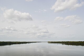
The Cacheu is a river of Guinea-Bissau also known as the Farim along its upper course. Its total length is about 257 km. One of its major tributaries is the Canjambari River.

Farim is a town of northern Guinea-Bissau. It sits on the north bank of the Farim/Cacheu River, about 215 km up the river from Cacheu. Population 8,661.

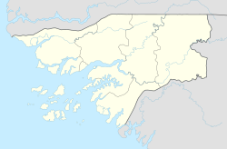
Cacheu is a region in western Guinea-Bissau, on the border with Senegal. It has an area of 5,175 km2 and a population estimated in 2004 at 164,676. Its capital is Cacheu. There has not been any local administration since the civil war of 1998-99 and all the social services are done by organs of civil society and other government agencies. It is a coastal region covered with Mangrove swamps, rain forest and tangled forest and receives an annual rainfall of more than 1,000 mm (39 in)

Guinea-Bissau Creole, also known as Kiriol or Crioulo, is a creole language whose lexicon derives mostly from Portuguese. It is spoken in Guinea Bissau, Senegal and The Gambia. It is also called by its native speakers as guinensi, kriyol, or portuguis.
There are 39 sectors of Guinea-Bissau which subdivide the regions. The sectors are further subdivided into smaller groups called sections ; which are further subdivided into populated places. Here are the following listed below, by region:

The Guinean mangroves are a coastal ecoregion of mangrove swamps in rivers and estuaries near the ocean of West Africa from Senegal to Sierra Leone.
The Cacheu River Mangroves Natural Park is a national park situated on the Cacheu River in Guinea-Bissau. It was established on 1 December 2000. This site is 886 km2. The park has been designated as a Ramsar site since 2015.
Bissau-Guinean Americans are Americans of Bissau-Guinean descent. As was the case with almost all current West African coastal countries, the first people in the United States from present-day Guinea-Bissau were imported as slaves. Thus, in the 21st century, there are many African Americans who have discovered, through DNA analysis, they descend mainly or at least partly, from Bissau-Guinean enslaved people.
Fort São José of Amura, also known locally as Amura Fort, is a fortification located in the city of Bissau, region of Bissau, capital of Guinea-Bissau, in West Africa.
André Álvares de Almada was a Cape Verdean writer, trader and explorer of mestiço (mixed) descent. He was one of the first recorded Cape Verdean writers.
The Cacheu and Cape Verde Company was a chartered company created by Portugal which operated the colonies of Cacheu and Cape Verde in the late 17th and early 18th centuries. It was created as part of the economic reforms of Luís de Meneses, 3rd Count of Ericeira, under King Peter II.
The Company of Cacheu and Rivers and Commerce of Guinea was a Portuguese colonial company. It succeeded the Guinea Coast Company and was intended to promote trade in manufactured fabrics, ivory, and slaves in the Guinea region of West Africa.
The Fort of Cacheu is located near the mouth of the Cacheu River, in the city of Cacheu, Cacheu region, in the northwest of Guinea-Bissau.