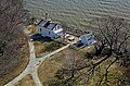
Jones Point is a geographic point on the Potomac River within the city of Alexandria, Virginia, United States. The Jones Point Light and Jones Point Park are located at the point, which is immediately North of the confluence of Hunting Creek and the Potomac River.

The George Washington Memorial Parkway, colloquially the G.W. Parkway, is a 25-mile-long (40 km) limited-access parkway that runs along the south bank of the Potomac River from Mount Vernon, Virginia, northwest to McLean, Virginia, and is maintained by the National Park Service (NPS). It is located almost entirely in Northern Virginia, except for a short portion of the parkway northwest of the Arlington Memorial Bridge that passes over Columbia Island in Washington, D.C.

The Pensacola Light is a lighthouse at Pensacola Bay, in Florida. It is the third iteration of what was originally a lightship, the Aurora Borealis, and remains an aid to navigation.

Alexandria National Cemetery is a United States National Cemetery, of approximately 5.5 acres (2.2 ha), located in the city of Alexandria, Virginia. Administered by the United States Department of Veterans Affairs, it is one of the original national cemeteries that were established in 1862. As of 2014, it was site to over 4,500 interments. The cemetery can accommodate the cremated remains of eligible individuals.

Sapelo Island Lighthouse is a lighthouse in Georgia, United States, near the southern tip of Sapelo Island. It is the nation's second-oldest brick lighthouse and the oldest survivor among lighthouses designed by Winslow Lewis. The lighthouse, oil building, the cistern, the footing of the 1905 light, the ruins of the fortification, and the associated range light were added to the National Register of Historic Places in 1997.
The Piney Point Lighthouse was built in 1836 located at Piney Point on the Potomac River in Maryland just up the river from the mouth of the Chesapeake Bay. The Coast Guard decommissioned it in 1964 and it has since become a museum. It is known as the Lighthouse of Presidents because several early US Presidents visited or stayed on the grounds.

Leesylvania State Park is located in the southeastern part of Prince William County, Virginia. The land was donated in 1978 by businessman Daniel K. Ludwig, and the park was dedicated in 1985 and opened full-time in 1992.

Horton Point Light is a lighthouse on the north side of Eastern Long Island, New York in the hamlet of Southold. The lighthouse and the grounds surrounding it are under the supervision of the Town of Southold Park District.

The boundary markers of the original District of Columbia are the 40 milestones that marked the four lines forming the boundaries between the states of Maryland and Virginia and the square of 100 square miles (259 km2) of federal territory that became the District of Columbia in 1801. Working under the supervision of three commissioners that President George Washington had appointed in 1790 in accordance with the federal Residence Act, a surveying team led by Major Andrew Ellicott placed these markers in 1791 and 1792. Among Ellicott's assistants were his brothers Joseph and Benjamin Ellicott, Isaac Roberdeau, George Fenwick, Isaac Briggs and an African American astronomer, Benjamin Banneker.

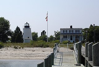
New Point Comfort Light is a lighthouse in the Virginia portion of the Chesapeake Bay, United States, off the tip of the Middle Peninsula. Finished in 1804, it is the third-oldest surviving light in the bay, and the tenth-oldest in the United States.

Old Point Comfort Light is a lighthouse located on the grounds of Fort Monroe in the Virginia portion of the Chesapeake Bay. It is the second oldest light in the bay and the oldest still in use. The lighthouse is owned and maintained by the U.S. Coast Guard and is listed on the National Register of Historic Places.
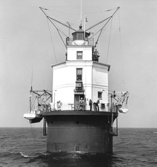
Smith Point Light is a caisson lighthouse in the Virginia portion of the Chesapeake Bay at the mouth of the Potomac River. It was added to the National Register of Historic Places in 2002.

The Alexandria Historic District is a National Historic Landmark District in Alexandria, Virginia. Encompassing all of the city's Old Town and some adjacent areas, this area contains one of the nation's best-preserved assemblages of the late-18th and early-19th century urban architecture. The district was locally designated in 1946 and was declared a National Historic Landmark in 1966.

Alexandria is an independent city in the northern region of the Commonwealth of Virginia, United States. It lies on the western bank of the Potomac River approximately 7 miles (11 km) south of downtown Washington, D.C. Alexandria is the third-largest principal city of the Washington metropolitan area, which is part of the larger Washington–Baltimore combined statistical area. As of 2022, the city's population of 159,467 made it the sixth-most populous city in Virginia and the 173rd-most populous city in the nation.
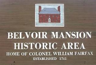
Belvoir was the plantation and estate of colonial Virginia's prominent William Fairfax family. Operated with the forced labor of enslaved people, it was located on the west bank of the Potomac River on the present site of Fort Belvoir in Fairfax County, Virginia.

Aquia Creek sandstone is a brown to light-gray freestone used extensively in building construction in Washington, D.C. in the late 18th and early 19th centuries. Quarried at Aquia Creek in Stafford County, Virginia, the stone was valuable for its ease of shaping and the quarry's proximity to the tidewater portion of the Potomac River, 45 miles (72 km) south of Washington.

Bear Island Light is a lighthouse on Bear Island near Mt. Desert Island, at the entrance to Northeast Harbor, Maine. It was first established in 1839. The present structure was built in 1889. It was deactivated in 1981 and relit as a private aid to navigation by the Friends of Acadia National Park in 1989. Bear Island Light was listed on the National Register of Historic Places as Bear Island Light Station on March 14, 1988.

Hendricks Head Light is a lighthouse in Southport, Maine marking the west side of the mouth of the Sheepscot River. The light station was established in 1829, and its present structures date to 1875. It was deactivated in 1933, but relit in 1951. The two-story wood keeper's house is now a private summer residence. The light is on continuously, showing white to the west and red to the east. It was listed on the National Register of Historic Places as Hendricks Head Light Station on November 20, 1987.
Alexandria, Virginia is an independent city in the Commonwealth of Virginia, located along the western bank of the Potomac River. The city of approximately 151,000 is about six miles south of downtown Washington, D.C.
Leesylvania was a plantation and historic home in Prince William County, Virginia, now part of Leesylvania State Park. During the 18th century, it was the home of Henry Lee II, his family and numerous slaves, and known for its productive land and especially the quality of its tobacco. Lee's sons Henry "Light-Horse Harry" Lee, Richard Bland Lee and Charles Lee, held prominent positions in Virginia during the American Revolutionary War and early federal government.