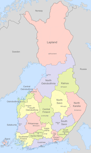
Finland is divided into 19 regions which are governed by regional councils that serve as forums of cooperation for the municipalities of each region. The councils are composed of delegates from the municipal councils. The main tasks of regional councils are regional planning, the development of enterprises, and education. Between 2004 and 2012, the regional council of Kainuu was elected via popular elections as part of an experimental regional administration.

Lahti is a city in Finland and the regional capital of Päijät-Häme. It is located in the Finnish Lakeland. The population of Lahti is approximately 121,000, while the sub-region has a population of approximately 204,000. It is the 9th most populous municipality in Finland, and the sixth most populous urban area in the country.

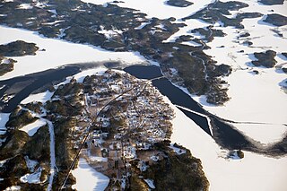
Sund is a municipality of Åland. It is an autonomous territory of Finland, and one of the official 27 national landscapes of Finland.

Valkeakoski is a town and municipality in Finland. It is located 35 kilometres (22 mi) south of Tampere, 45 km (28 mi) north of Hämeenlinna and 150 km (93 mi) north of Helsinki in the Pirkanmaa region. The municipality has a population of 20,694 (31 December 2023) and covers an area of 372.03 square kilometres (143.64 sq mi) of which 100.06 km2 (38.63 sq mi) is water. The population density is 76.07 inhabitants per square kilometre (197.0/sq mi).
Kolari is a municipality of Finland at the Swedish border, which follows the Torne River, the longest free-flowing river in Europe.
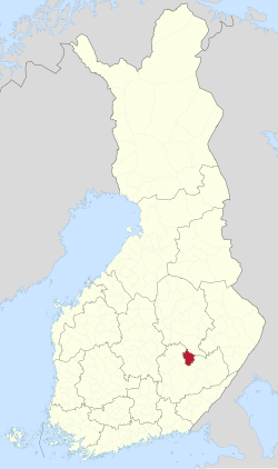
Juva is a municipality of Finland. It is located in the Southern Savonia region some 270 kilometres (170 mi) North-East of Helsinki. It was founded on 19 January 1442, and is the oldest parish/municipality in Finland whose exact date of birth is known. At the time, it was only the second parish in Eastern Finland, and later, several other parishes were separated from it, such as Sääminki,, Kuopio, Iisalmi, Pieksämäki, Joroinen, Leppävirta, Siilinjärvi, Lapinlahti and Maaninka. Secular municipal administration was established in 1868.

Hollola is a municipality of Finland, located in the western part of the Päijänne Tavastia region. The municipality is unilingually Finnish and has a population of 22,885 and covers an area of 727.47 square kilometres (280.88 sq mi) of which 68.66 km2 (26.51 sq mi) is water. The population density is 35.13 inhabitants per square kilometre (91.0/sq mi).

Iisalmi is a town and municipality in the region of Northern Savonia in Finland. It is located 87 kilometres (54 mi) north of Kuopio and south of Kajaani. The municipality has a population of 20,618, which makes it the second largest of the five towns in Northern Savonia in population, only Kuopio being larger. It covers an area of 872.20 square kilometres (336.76 sq mi) of which 109.22 km2 (42.17 sq mi) is water. The population density is 27.02 inhabitants per square kilometre (70.0/sq mi). The municipality is unilingually Finnish.

Kitee is a town and a municipality of Finland. It is located in the province of Eastern Finland and is part of the North Karelia region, about 65 kilometres (40 mi) south of Joensuu and about 175 kilometres (109 mi) northeast of Lappeenranta. The municipality has a population of 9,689 and covers an area of 1,724.41 square kilometres (665.80 sq mi) of which 275.61 km2 (106.41 sq mi) is water. The population density is 7.73 inhabitants per square kilometre (20.0/sq mi).

Kuusamo is a town and municipality in Finland. It is located in Koillismaa, the northeastern part of the Northern Ostrobothnia region. The municipality has a population of 15,019 and covers an area of 5,808.92 square kilometres (2,242.84 sq mi) of which 830.81 km2 (320.78 sq mi) is water. The population density is 3.02 inhabitants per square kilometre (7.8/sq mi).

Laukaa is a municipality of Finland. It is located next to Jyväskylä and is part of the Central Finland region. The municipality has a population of 18,762 and covers an area of 825.59 square kilometres (318.76 sq mi) of which 177.09 km2 (68.37 sq mi) is water. The population density is 28.93 inhabitants per square kilometre (74.9/sq mi).

Leppävirta is a municipality of Finland. It is located in the Northern Savonia region, 56 kilometres (35 mi) south of Kuopio along the Finnish national road 5. The municipality has a population of 9,049 (31 December 2023) and covers an area of 1,519.64 square kilometres (586.74 sq mi) of which 383.62 km2 (148.12 sq mi) is water. The population density is 7.96 inhabitants per square kilometre (20.6/sq mi).

Lohja is a town in Finland, located in the southern interior of the country. Lohja is situated in the western part of the Uusimaa region. The population of Lohja is approximately 46,000. It is the 25th most populous municipality in Finland. Lohja is part of the Helsinki sub-region, but not directly part of the Helsinki metropolitan area.

Nakkila is a municipality of Finland. It is located in the province of Western Finland and is part of the Satakunta region, 19 kilometres (12 mi) southeast of Pori. The Kokemäki River flows along the center of Nakkila. The municipality has a population of 4,966 and covers an area of 184.88 square kilometres (71.38 sq mi) of which 1.97 km2 (0.76 sq mi) is water. The population density is 27.15 inhabitants per square kilometre (70.3/sq mi). The municipality is unilingually Finnish. The name Nackeby was earlier used in Swedish.

Pieksämäki is a town and municipality of Finland. It is located in the Southern Savonia region, about 75 kilometres (47 mi) north of Mikkeli, 85 kilometres (53 mi) east of Jyväskylä and 95 kilometres (59 mi) south of Kuopio. The town has a population of 17,050 and covers an area of 1,836.22 square kilometres (708.97 sq mi) of which 266.76 km2 (103.00 sq mi) is water. The population density is 10.87 inhabitants per square kilometre (28.2/sq mi). Neighbour municipalities are Hankasalmi, Joroinen, Juva, Kangasniemi, Leppävirta, Mikkeli, Rautalampi and Suonenjoki.
Puumala is a municipality of Finland. It is located in the Southern Savonia region. The municipality has a population of 2,108 and covers an area of 1,237.75 square kilometres (477.90 sq mi) of which 443.17 km2 (171.11 sq mi) is water. The population density is 2.65 inhabitants per square kilometre (6.9/sq mi).

Reisjärvi is a municipality of Finland.

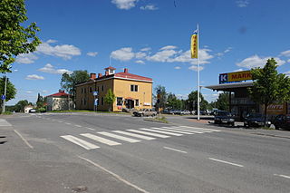
Sievi is a municipality of Finland.

Sotkamo is a municipality of Finland, located in the Kainuu region about 40 kilometres (25 mi) east of Kajaani, the capital of Kainuu. Vuokatti, in west of Sotkamo, is the most populous village in the municipality and also a popular skiing resort. Both Hiidenportti National Park and Tiilikkajärvi National Park are located in the municipality.
Tohmajärvi is a municipality of Finland. It is located in the North Karelia region. The municipality has a population of 4,066 (31 December 2023) and covers an area of 895.36 square kilometres (345.70 sq mi) of which 57.62 km2 (22.25 sq mi) is water. The population density is 4.85 inhabitants per square kilometre (12.6/sq mi). The municipality is unilingually Finnish.