
The Yakima River is a tributary of the Columbia River in south central and eastern Washington state, named for the indigenous Yakama people. Lewis and Clark mention in their journals that the Chin-nâm pam called the river Tâpe têtt, possibly from the French tape-tête, meaning "head hit". The length of the river from headwaters to mouth is 214 miles (344 km), with an average drop of 9.85 feet per mile (1.866 m/km). It is the longest river entirely in Washington state.

The Red River, or sometimes the Red River of the South to differentiate it from the Red River in the north of the continent, is a major river in the Southern United States. It was named for its reddish water color from passing through red-bed country in its watershed. It is known as the Red River of the South to distinguish it from the Red River of the North, which flows between Minnesota and North Dakota into the Canadian province of Manitoba. Although once a tributary of the Mississippi River, the Red River is now a tributary of the Atchafalaya River, a distributary of the Mississippi that flows separately into the Gulf of Mexico. This confluence is connected to the Mississippi River by the Old River Control Structure.

The Yakama are a Native American tribe with nearly 10,851 members, based primarily in eastern Washington state.

The Holston River is a 136-mile (219 km) river that flows from Kingsport, Tennessee, to Knoxville, Tennessee. Along with its three major forks, it comprises a major river system that drains much of northeastern Tennessee, southwestern Virginia, and northwestern North Carolina. The Holston's confluence with the French Broad River at Knoxville marks the beginning of the Tennessee River.

The Cle Elum River is a tributary of the Yakima River, approximately 28 miles (45 km) long in the U.S. state of Washington. A Northern Pacific Railway station at the future site of the city of Cle Elum, Washington was named Clealum after the Kittitas name Tie-el-Lum, meaning "swift water", referring to the Cle Elum River. In 1908, Clealum was altered to Cle Elum. This spelling came to be used for the river as well. Some maps in the 1850s also have the river labeled as Samahma River.

The Caney River is a 180-mile-long (290 km) river in southern Kansas and northeastern Oklahoma. The river is a tributary of the Verdigris River, and is usually a flatwater stream.

The Entiat River is a tributary of the Columbia River, joining the Columbia near Entiat. The United States Geological Survey (USGS) lists two variant names for the Entiat River: En-ti-at-kwa River and Entiatqua River. The river's name is derived from the Columbia-Moses (Salishan) term /nt'yátkw/ [nt'iátkw], meaning "place of grassy water"; another source states that it was called Enteatqua which means "Rapid Water" or "Rushing Water." The name, spelled "Entiat", was selected for the river in 1958 by the Chelan County Public Utility District.

The Naches River is a tributary of the Yakima River in central Washington in the United States. Beginning as the Little Naches River, it is about 75 miles (121 km) long. After the confluence of the Little Naches and Bumping River the name becomes simply the Naches River. The Naches and its tributaries drain a portion of the eastern side of the Cascade Range, east of Mount Rainier and northeast of Mount Adams. In terms of discharge, the Naches River is the largest tributary of the Yakima River.

The Tieton River is a tributary of the Naches River, in Yakima County, Washington in the United States.

The Bumping River is a tributary of the Naches River, in Washington in the United States. It flows down the east side of the Cascade Range, through Wenatchee National Forest and the William O. Douglas Wilderness. From its source at Fish Lake near Crag Mountain, it flows northeast to Bumping Lake, a natural lake enlarged and regulated by Bumping Lake Dam. Below the dam, the Bumping River continues flowing northeast. It is joined by the American River, its main tributary, a few miles above its mouth where it joins the Little Naches River to form the Naches River.

Cle Elum Lake is a lake and reservoir along the course of the Cle Elum River, in Washington state USA. At the site of the future city of Cle Elum, Washington, a Northern Pacific Railway station was named Clealum after the Kittitas name Tle-el-Lum (tlielləm), meaning "swift water", referring to the Cle Elum River. The lake was also labeled as Kleattam Lake in maps of the 1850s.

Kachess Lake is a lake and reservoir along the course of the Kachess River in Kittitas County, Washington, United States. The upper part of the lake, north of a narrows, is called Little Kachess Lake. The Kachess River flows into the lake from the north, and out from the south. Kachess Lake is the middle of the three large lakes which straddle Interstate 90 north of the Yakima River in the Cascade Range. The other two are Cle Elum Lake, the easternmost which is also north of I-90 and Keechelus Lake, the westernmost, which is south of I-90.

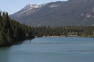
Keechelus Lake is a lake and reservoir in the northwest United States, near Hyak in Kittitas County, Washington. Approximately fifty miles (80 km) southeast of Seattle and a few miles southeast of Snoqualmie Pass, it is the source of the Yakima River.

The Teanaway River is a tributary of the Yakima River, in the U.S. state of Washington. It flows into the Yakima River near Cle Elum. The Teanaway River is part of the Columbia River basin, being a tributary of the Yakima River, which is a tributary to the Columbia River. The river's name comes from Sahaptin, possibly /tyawnawí-ins/, "drying place".

Umtanum Ridge is a long anticline mountain ridge in Yakima County and Kittitas County in the U.S. state of Washington. It runs for approximately 55 miles east-southeast from the Cascade Range, through the Yakima Training Center to the edge of the Columbia River at Priest Rapids Dam and Hanford Reach. The eastern end of Umtanum Ridge enters Hanford Reach National Monument and the Hanford Site. Umtanum Ridge is paralleled on the north by Manastash Ridge and on the south by Yakima Ridge. The Yakima River cuts through the ridge at the Umtanum Ridge Water Gap.
Lake Easton is a lake and reservoir along the course of the Yakima River in the U.S. state of Washington. It is located in Township 20N, Range 13E. The Yakima River flows into the lake from the west, and out to the southwest, through the 1929 Easton Diversion Dam. The Kachess River also flows into the lake from the north, where it effectively empties into the Yakima River.
The following outline is provided as an overview of and topical guide to infrastructure of the U.S. state of Washington.


