Kamphaeng Phet

Last updated
Kamphaeng Phet
กำแพงเพชร
Town
Kamphaeng Phet City Pillar Shrine.jpg
Kamphaeng Phet city pillar shrine
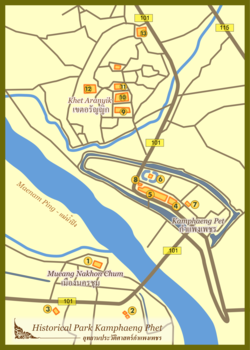
Histparkkamphet.png
Map of Kamphaeng Phet
CountryFlag of Thailand.svg  Thailand
Province Kamphaeng Phet Province
Area
  Metro
14.9 km2 (5.8 sq mi)
Population
 (2020)
  Town28,817 [1]
Time zone UTC+7 (ICT)

Kamphaeng Phet is a town ( thesaban mueang ) in central Thailand, former capital of the Kamphaeng Phet Province. It covers the complete tambon Nai Mueang of the Mueang Kamphaeng Phet district. As of 2020, it has a population of 28,817.

Contents

Wat Chang Rop (Kamphaeng Phet).jpg
Wat Chang Rop (Kamphaeng Phet) 04.JPG
Wat Singha (Kamphaeng Phet) 03.JPG
Wat Phra That (Kamphaeng Phet) 05.JPG
Kamphaeng Phet Historical Park.jpg
Kamphaeng Phet historical park 03.JPG
Kamphaeng Phet national museum Kamphaeng Phet National Museum.jpg
Kamphaeng Phet national museum
Wat Phra Borom That Wat Phra Borom That Kamphaeng Phet, Thailand. 03.jpg
Wat Phra Borom That
Wat Bang Wat Bang1.jpg
Wat Bang

History

Kamphaeng Phet was an ancient outpost town during the Sukhothai period, as evidenced by the city walls and fortifications that remain today. Before the creation of the city, legends says that there were two cities present in the location; Chakangrao (ชากังราว) and Nakhon Chum (นครชุม). [2] Chakangrao was built on the east bank of the Ping River while Nakhon Chum was built on the west bank of the Ping River. [2]

Kamphaeng Phet received municipality status on March 11, 1936. [3] When the municipality was established, it had an operation area of 4.5 square kilometers. Later in 1966, it expanded to an area of 14.9 square kilometers.

Demographics

Since 2005, the population of Kamphaeng Phet has been decreasing. [4]

Estimation date31 Dec 200531 Dec 201031 Dec 201531 Dec 2019
Population30,11429,37429,19128,817

Climate

Climate data for Kamphaeng Phet (1991–2020)
MonthJanFebMarAprMayJunJulAugSepOctNovDecYear
Record high °C (°F)37.0
(98.6)
39.8
(103.6)
40.8
(105.4)
43.0
(109.4)
41.8
(107.2)
39.6
(103.3)
38.0
(100.4)
37.8
(100.0)
36.2
(97.2)
36.1
(97.0)
36.5
(97.7)
35.4
(95.7)
43.0
(109.4)
Mean daily maximum °C (°F)32.0
(89.6)
34.1
(93.4)
35.9
(96.6)
37.2
(99.0)
35.5
(95.9)
33.9
(93.0)
33.1
(91.6)
32.7
(90.9)
32.8
(91.0)
32.4
(90.3)
32.1
(89.8)
31.2
(88.2)
33.6
(92.4)
Daily mean °C (°F)24.9
(76.8)
26.8
(80.2)
28.9
(84.0)
30.6
(87.1)
29.6
(85.3)
28.7
(83.7)
28.2
(82.8)
27.9
(82.2)
27.9
(82.2)
27.5
(81.5)
26.4
(79.5)
24.6
(76.3)
27.7
(81.8)
Mean daily minimum °C (°F)19.1
(66.4)
20.5
(68.9)
23.0
(73.4)
25.1
(77.2)
25.5
(77.9)
25.4
(77.7)
25.1
(77.2)
24.9
(76.8)
24.7
(76.5)
24.0
(75.2)
22.0
(71.6)
19.5
(67.1)
23.2
(73.8)
Record low °C (°F)10.1
(50.2)
12.2
(54.0)
14.8
(58.6)
19.9
(67.8)
20.8
(69.4)
22.3
(72.1)
21.4
(70.5)
22.5
(72.5)
21.6
(70.9)
17.0
(62.6)
12.6
(54.7)
8.2
(46.8)
8.2
(46.8)
Average precipitation mm (inches)5.3
(0.21)
12.8
(0.50)
40.4
(1.59)
56.2
(2.21)
191.1
(7.52)
157.2
(6.19)
175.8
(6.92)
180.3
(7.10)
268.0
(10.55)
166.3
(6.55)
27.5
(1.08)
8.7
(0.34)
1,289.6
(50.77)
Average precipitation days (≥ 1.0 mm)1.01.43.03.911.712.714.215.415.710.92.90.893.6
Average relative humidity (%)70.666.065.566.075.180.681.683.584.082.977.873.275.6
Average dew point °C (°F)18.5
(65.3)
19.1
(66.4)
21.0
(69.8)
22.7
(72.9)
24.2
(75.6)
24.7
(76.5)
24.5
(76.1)
24.6
(76.3)
24.7
(76.5)
24.0
(75.2)
21.8
(71.2)
19.0
(66.2)
22.4
(72.3)
Mean monthly sunshine hours 257.3243.0238.7243.0198.4156.0120.9117.8144.0179.8219.0257.32,375.2
Mean daily sunshine hours 8.38.67.78.16.45.23.93.84.85.87.38.36.5
Source 1: World Meteorological Organization [5]
Source 2: Office of Water Management and Hydrology, Royal Irrigation Department (sun 1981–2010) [6] (extremes) [7]

See also

Related Research Articles

<span class="mw-page-title-main">Khon Kaen</span> City Municipality in Thailand

Khon Kaen is the capital of Khon Kaen province and the fourth largest city in Thailand. It is one of the four major cities of Isan, Thailand, also known as the "big four of Isan", the others being Udon Thani, Nakhon Ratchasima, and Ubon Ratchathani.

<span class="mw-page-title-main">Nakhon Sawan province</span> Province of Thailand

Nakhon Sawan is one of Thailand's seventy-six provinces (changwat). It lies in lower northern Thailand, neighbouring the provinces of Kamphaeng Phet, Phichit, Phetchabun, Lopburi, Sing Buri, Chai Nat, Uthai Thani, and Tak.

<span class="mw-page-title-main">Kamphaeng Phet province</span> Province of Thailand

Kamphaeng Phet is a province in upper central Thailand. It borders the provinces of Sukhothai to the north; Phitsanulok to the northeast; Phichit to the east; Nakhon Sawan to the south; and Tak to the west and northwest, covering over 8,607.49 square kilometres (3,323.37 sq mi) and is the fourth-largest provinces in central Thailand. Kamphaeng Phet has the Ping River flow through is main river of the province, making river flats make up much of the east of the province, while the west is mountainous which is part of Dawna Range and it covered with plentifully forest. Kamphaeng Phet known its natural environment and has a long history. National and historical parks in the province include Kamphaeng Phet Historical Park, Khlong Lan National Park, and Mae Wong National Park.

<span class="mw-page-title-main">Surat Thani</span> City in Surat Thani Province in southern Thailand

Surat Thani is a city in Amphoe Mueang Surat Thani, Surat Thani Province, southern Thailand. It lies 651 km (405 mi) south of Bangkok. It is the capital of Surat Thani Province. The city has a population of 132,040 (2019), and an area of 68.97 km2 (26.63 sq mi). The city's population density is 1,914 inhabitants per km2.

<span class="mw-page-title-main">Trang, Thailand</span> City Municipality in Trang, Thailand

Thesaban nakhon Trang, City of Trang, or Trang, also called Mueang Thap Thiang (เมืองทับเที่ยง), is a thesaban nakhon and the capital of Trang Province, Thailand. The city has a population of 59,637 (2005) and covers the whole tambon Thap Thiang of Mueang Trang district. Trang is 839 km south of Bangkok.

<span class="mw-page-title-main">Chaiyaphum</span> Town in Thailand

Chaiyaphum is a town in northeastern Thailand, capital of Chaiyaphum Province. As of 2015 it had a population of 58,350, and covers the full tambon Nai Mueang of Mueang Chaiyaphum District. Chaiyaphum is 337 road kilometres northeast of Bangkok.

<span class="mw-page-title-main">Sakon Nakhon</span> City Municipality in Thailand

Sakon Nakhon is a city in Thailand within the Isan region, and capital city of Sakon Nakhon Province as well as Mueang Sakon Nakhon District, with a population of approximately 76,000. Sakon Nakhon covers the whole tambon of That Choeng Chum and parts of tambons Ngio Don, Huai Yang, Dong Mafai, That Na Weng and Hang Hong. Sakon Nakhon is 651 km (405 mi) north-east of Bangkok by road.

<span class="mw-page-title-main">Phetchaburi</span> Town in Phetchaburi Province, Thailand

Phetchaburi or Phet Buri is a town in southern Thailand, capital of Phetchaburi Province. In Thai, Phetchaburi means "city of diamonds". It is approximately 160 km south of Bangkok, at the northern end of the Thai peninsula. As of 2005, the town had a population of 26,181 and covers the two tambon Tha Rap and Khlong Krachaeng.

<span class="mw-page-title-main">Tak, Thailand</span> Town in Thailand

Tak is a town in north-west Thailand, capital of the Tak Province and the Tak district. As of 2005 the town had a population of 19,900 and an area of 7.27 km2. It covers the tambon Rahaeng, Nong Luang, Chiang Ngoen, and Hua Diat. It is on the Ping River, 418 km north-north-west of Bangkok.

Narathiwat is a town in southern Thailand and capital of Narathiwat Province. The town is in the Mueang Narathiwat District and was established in 1936. As of 2008, the population was 40,521. It lies 1,141 km south of Bangkok.

<span class="mw-page-title-main">Ranong</span> Town in Ranong Province, Thailand

Ranong is a town in southern Thailand, capital of the Ranong Province and the Mueang Ranong District. The town covers completely the area of the tambon Khao Niwet (เขานิเวศน์). As of 2005, it had a population of 16,163. Ranong lies 586 kilometres (364 mi) south-southwest of Bangkok by road.

<span class="mw-page-title-main">Chumphon</span> Town in Chumphon Province, Thailand

Chumphon is a town in southern Thailand, capital of the Chumphon Province and Mueang Chumphon District. The city is about 463 kilometers from Bangkok. As of 2018 it had a population of around 33,600. The town covers the commune (tambon) Tha Taphao completely and parts of tambons Bang Mak, Wang Phai, Na Thung, Tak Daet, and Khun Krathing. Its main economic activity is agriculture.

Prachinburi is a town in central Thailand, capital of Prachinburi Province. It covers the entire tambon Na Mueang of the Mueang Prachinburi District. As of 2000, the population of the town was 25,157.

<span class="mw-page-title-main">Nakhon Phanom</span> Town in Nakhon Phanom Province, Thailand

Nakhon Phanom is a town in northeastern Thailand, capital of Nakhon Phanom Province. The town covers tambons Nai Mueang and Nong Saeng and parts of tambons At Samat and Nong Yat, all in Mueang Nakhon Phanom District. As of 2006, it had a population of 27,591. This town is located 736 kilometres (457 mi) northeast of Bangkok.

<span class="mw-page-title-main">Mueang Kamphaeng Phet district</span> District in Kamphaeng Phet, Thailand

Mueang Kamphaeng Phet is the capital district of Kamphaeng Phet province, central Thailand.

<span class="mw-page-title-main">Kosamphi Nakhon district</span> District in Kamphaeng Phet, Thailand

Kosamphi Nakhon is a district (amphoe) in the northwestern part of Kamphaeng Phet province, central Thailand.

<span class="mw-page-title-main">Kamphaeng Phet Historical Park</span> UNESCO World Heritage Site in Kamphaeng Phet Province, Thailand

Kamphaeng Phet Historical Park is an archeological site in Kamphaeng Phet, Thailand. Along with Sukhothai Historical Park and Si Satchanalai historical park, it is a part of the UNESCO World Heritage Site Historic Town of Sukhothai and Associated Historic Towns. Major features in the Kamphaeng Phet Historical Park include archaeological remains of ancient sites such as Mueang Chakangrao to the east of the Ping River, Mueang Nakhon Chum to the west and Mueang Trai Trueng some 18 km from the town to the southwest. Chakangrao, the ancient Kamphaeng Phet town, had the same town planning concept as the old Sukhothai and Si Satchanalai, with separate zones for religious sites both within and outside of town limits. Structures are usually large and made of laterite. Religious sites on the west bank of the Ping River at Nakhon Chum are built of bricks and of smaller size.

<span class="mw-page-title-main">Historic Town of Sukhothai and Associated Historic Towns</span> UNESCO World Heritage Site in Sukhothai and Kamphaeng Phet provinces in Thailand

The Historic Town of Sukhothai and Associated Historic Towns is a UNESCO World Heritage Site which consists of Sukhothai historical park, Kamphaeng Phet historical park and Si Satchanalai historical park. These historical parks preserve the remains of the three main cities of the Sukhothai Kingdom which flourished during the 13th and 14th century CE. The Sukhothai Kingdom is viewed as having been the first of the Thai kingdoms.

<span class="mw-page-title-main">Kamphaeng Phet Provincial Administrative Organization Stadium</span>

Kamphaengphet Provincial Administrative Organization Stadium or Cha Kung Rao Stadium is a multi-purpose stadium in Kamphaeng Phet Province, Thailand. It is currently used mostly for football matches and is the home stadium of Kamphaeng Phet F.C. The stadium holds 2,406 people.

<span class="mw-page-title-main">Nakhon Sawan</span> City Municipality in Thailand

Nakhon Sawan is a city in Thailand. The name literally means "Heavenly City". The city is the capital of Nakhon Sawan Province, and covers the complete subdistrict (tambon) of Pak Nam Pho and parts of Khwae Yai, Nakhon Sawan Tok, Nakhon Sawan Ok and Wat Sai, as well as all of Mueang Nakhon Sawan district. As of 31 December 2020, it has a population of 82,305. Nakhon Sawan is 238 km north of Bangkok.

References

  1. "Thailand: Major Cities, Towns & Communes - Population Statistics, Maps, Charts, Weather and Web Information".
  2. 1 2 "เล่าเรื่องเมืองชากังราว องค์การบริหารส่วนจังหวัดกำแพงเพชร (อบจ.กำแพงเพชร)".
  3. "ประวัติเทศบาล".
  4. "THAILAND: Major Cities, Towns & Communes".
  5. "World Meteorological Organization Climate Normals for 1991–2020". World Meteorological Organization. Retrieved 12 October 2023.
  6. "ปริมาณการใช้น้ำของพืชอ้างอิงโดยวิธีของ Penman Monteith (Reference Crop Evapotranspiration by Penman Monteith)" (PDF) (in Thai). Office of Water Management and Hydrology, Royal Irrigation Department. p. 36. Retrieved 1 August 2016.
  7. "Climatological Data for the Period 1981–2010". Thai Meteorological Department. Retrieved 4 August 2016.

16°28′52″N99°31′20″E / 16.48111°N 99.52222°E / 16.48111; 99.52222