
Masovian Voivodeship, also known as Mazovia Province and Mazowsze Province, is a voivodeship (province) in east-central Poland, containing Poland's capital Warsaw.
There are 23 national parks in Poland. These were formerly run by the Polish Board of National Parks, but in 2004 responsibility for their management was transferred to what is now the Ministry of Climate and the Environment. Most national parks are divided into strictly and partially protected zones. They currently encompass around 186000 hectares of forest, or around 2% of all the country's woodlands.

The Lublin Voivodeship, also known as the Lublin Province, is a voivodeship (province) of Poland, located in southeastern part of the country. It was created on January 1, 1999, out of the former Lublin, Chełm, Zamość, Biała Podlaska and (partially) Tarnobrzeg and Siedlce Voivodeships, pursuant to Polish local government reforms adopted in 1998. The region is named after its largest city and regional capital, Lublin, and its territory is made of four historical lands: the western part of the voivodeship, with Lublin itself, belongs to Lesser Poland, the eastern part of Lublin Area belongs to Red Ruthenia, and the northeast belongs to Polesie and Podlasie. Lublin Voivodeship borders Subcarpathian Voivodeship to the south, Świętokrzyskie Voivodeship to the south-west, Masovian Voivodeship to the west and north, Podlaskie Voivodeship along a short boundary to the north, Belarus and Ukraine to the east. The region's population as of 2019 was 2,112,216. It covers an area of 25,155 square kilometres (9,712 sq mi).

Forests cover an estimated 38.5% of Poland's territory, and are mostly owned by the state. And are increasing at a fast rate by 2035 Polands forest percentage will be 42-46%. Western and northern parts of Poland as well as the Carpathian Mountains in the extreme south, are much more forested than eastern and central provinces. The most forested administrative districts of the country are: Lubusz Voivodeship (60,2%), Subcarpathian Voivodeship (58,2%), and Pomeranian Voivodeship (50,1%). The least forested are: Łódź Voivodeship (36%), Masovian Voivodeship (34,6%), and Lublin Voivodeship (32,8%).

Bieszczady County is a unit of territorial administration and local government (powiat) in Subcarpathian Voivodeship, in the extreme south-east of Poland, on the border with Ukraine. It takes its name from the Bieszczady mountain range. The county was created on January 1, 1999, as a result of the Polish local government reforms passed in 1998. In 2002 the western part of the county was split off to form Lesko County. The only town in Bieszczady County is now Ustrzyki Dolne, the county seat, which lies 80 kilometres (50 mi) south-east of the regional capital Rzeszów.

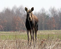
Kampinos Forest is a large forest complex located in Masovian Voivodeship, west of Warsaw in Poland.

The Slovincian National Park, also known as Słowiński National Park, is a national park in Pomeranian Voivodeship, northern Poland. It is situated on the Baltic coast, between Łeba and Rowy. The northern boundary of the park consists of 32.5 kilometres (20.2 mi) of coastline.

Wigry National Park is a national park in Podlaskie Voivodeship in north-eastern Poland. It covers parts of the Masurian Lake District and Augustów Primeval Forest. It is named after lake Wigry, the largest of the park's many lakes. It is also classed as a Ramsar wetland site, one of 13 such sites in Poland.

Biebrza National Park is a national park in Podlaskie Voivodeship, northeastern Poland, along the Biebrza River.

Narew National Park is a National Park in Podlaskie Voivodeship, north-eastern Poland, created in 1996. Prior to that, its area was part of the Narew Landscape Park.

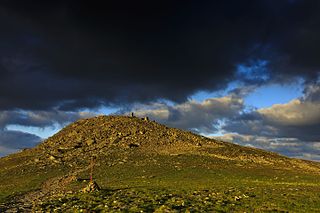
Bieszczady National Park is the third-largest national park in Poland, located in Subcarpathian Voivodeship in the extreme southeast corner of the country. In 2021, the national park became a UNESCO World Heritage Site.
Babia Góra National Park is one of the 23 national parks in Poland, located in the southern part of the country, in Lesser Poland Voivodeship, on the border with Slovakia. Its headquarters are located in Zawoja. A Nature Reserve which roughly covered the area of the modern-day national park was created in 1933, with the actual park established on October 30, 1954. Since 1976, it has been designated by UNESCO as a biosphere reserve.

Tuchola Forest National Park is a national park in Poland, created on July 1, 1996. It covers an area of 46.13 square kilometres (17.81 sq mi) of forests, lakes, meadows and peatlands. The park is in the northern part of Poland, in Chojnice County in Pomeranian Voivodeship, in the heart of the Tuchola Forest, the largest woodland in Poland. It is surrounded by a larger protected area called Zaborski Landscape Park. The park forms the core of the Tuchola Forest Biosphere Reserve, designated by UNESCO in 2010.

Drawa National Park is located in north-western Poland, on the border of Greater Poland, Lubusz and West Pomeranian Voivodeships. The park is a part of the huge Drawsko Forest, which lies on the vast Drawsko Plain. It takes its name from the River Drawa. The national park was created in 1990 and initially covered 86.91 km2. Later, it was enlarged to 113.42 square kilometres (43.79 sq mi) of which forests account for 96.14 km2, and water bodies cover 9.37 km2.

Stołowe Mountains National Park, anglicized to Table Mountains National Park, is a national park in southwestern Poland. It comprises the Polish section of the Table Mountains, which are part of the Sudetes range. It is located in Kłodzko County of the Lower Silesian Voivodeship, at the border with the Czech Republic. Created in 1993, the park covers an area of 63.39 square kilometres (24.48 sq mi), of which forests account for 57.79 km2. The area of strict protection is 3.76 km2.
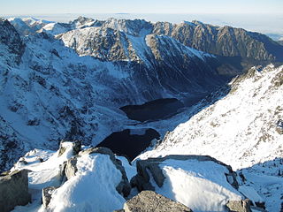
Tatra National Park is a national park located in the Tatra Mountains in Tatra County, in the Lesser Poland Voivodeship in central-southern Poland. The park is headquartered in the town of Zakopane.

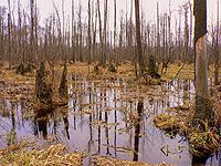
Białowieża National Park is a national park in Podlaskie Voivodeship, in Eastern Poland adjacent to the border with Belarus. The total area of the park is 105.2 square kilometres (40.6 sq mi). It is located 62 km (39 mi) southeast of Białystok (Poland). It is known for the protection of the best preserved part of the Białowieża Forest, Europe's last temperate primaeval forest fragment that once allegedly stretched across the European Plain. It is home to the world's largest population of European bison, the continent's heaviest land animals. The border between the two countries runs through the forest, the Belovezhskaya Pushcha National Park is adjacent on the Belarus side of the border. There is a border crossing for hikers and cyclists within the forest. According to one study, the park brings in tourist revenues of about 72 million zloty per year.
Gmina Kampinos is a rural gmina in Warsaw West County, Masovian Voivodeship, in east-central Poland. Its seat is the village of Kampinos, which lies approximately 25 kilometres (16 mi) west of Ożarów Mazowiecki and 38 km (24 mi) west of Warsaw.
Gmina Puszcza Mariańska is a rural gmina in Żyrardów County, Masovian Voivodeship, in east-central Poland. Its seat is the village of Puszcza Mariańska, which lies approximately 10 kilometres (6 mi) south-west of Żyrardów and 52 km (32 mi) south-west of Warsaw.
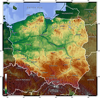
Poland is a country that extends across the North European Plain from the Sudetes and Carpathian Mountains in the south to the sandy beaches of the Baltic Sea in the north. Poland is the fifth-most populous country of the European Union and the ninth-largest country in Europe by area. The territory of Poland covers approximately 312,696 km2 (120,733 sq mi), of which 98.52% is land and 1.48% is water. The Polish coastline was estimated at 770 km (478 mi) in length. Poland's highest point is Rysy, at 2,500 m (8,202 ft).


 Green forester moth


