The Republic of Equatorial Guinea is located in west central Africa. Bioko Island lies about 40 kilometers (24.9 mi) from Cameroon. Annobón Island lies about 595 kilometres (370 mi) southwest of Bioko Island. The larger continental region of Río Muni lies between Cameroon and Gabon on the mainland; it includes the islands of Corisco, Elobey Grande, Elobey Chico, and adjacent islets. The total land area is 28,051 km2 (10,831 sq mi). It has an Exclusive Economic Zone of 303,509 km2 (117,185 sq mi).

Transport in Guinea is composed by a variety of systems that people in the country use to get around as well as to and from domestic and international destinations. The railway from Conakry to Kankan ceased operating in the mid-1980s. Most vehicles in Guinea are 20+ years old, and cabs are any four-door vehicle which the owner has designated as being for hire. Domestic air services are intermittent. Conakry International Airport is the largest airport in the country, with flights to other cities in Africa as well as to Europe.

The geography of Guinea-Bissau is that of low coastal plains bordering the Atlantic Ocean. The country borders Senegal in the north and Guinea in the southeast.
Cotonou is the largest city in Benin. Its official population count was 679,012 inhabitants in 2012; however, over two million people live in the larger urban area.
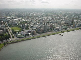
Libreville is the capital and largest city of Gabon. Occupying 65 square kilometres (25 sq mi) in the northwestern province of Estuaire, Libreville is a port on the Komo River, near the Gulf of Guinea. As of the 2013 census, its population was 703,904.
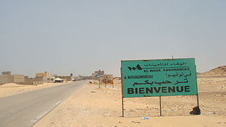
Nouadhibou is the second largest city in Mauritania and serves as a major commercial center. The city has about 118,000 inhabitants. It is situated on a 65-kilometre peninsula or headland called Ras Nouadhibou, Cap Blanc, or Cabo Blanco, of which the western side has the city of La Güera. Nouadhibou is consequently located merely a couple of kilometers from the border between Mauritania and Morocco. Its current Mayor is Elghassem Ould Bellali, who was installed on 15 October 2018.

Mamou is a city and sub-prefecture in a valley of the Fouta Djallon area of Guinea. The population is 376,269.

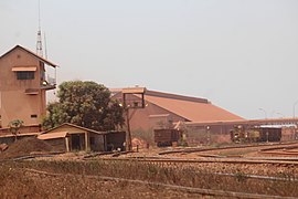
Fria is a town and Sub-prefecture in Lower Guinea, lying north of Conakry near the Amaria Dam on the Konkouré River. As of 2014 it had a population of 61,691 people.

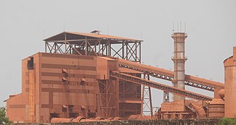
Dabola is a town in central Guinea. As of 2014 it had a population of 38,617 people. It grew around the railway line from Conakry to Kankan and is known for the Tinkisso Falls and for its important dam.

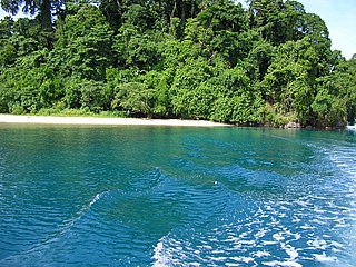
Kribi is a beach resort and sea port in Cameroon.
Kimbe is the capital of the province of West New Britain in Papua New Guinea, and the largest settlement on the island. The bustling town of Kimbe is the third largest port in Papua New Guinea and is the fastest growing city in the South Pacific. The town of Kimbe is served by Hoskins Airport.
Sangarédi is a mining town and sub-prefecture in western Guinea, where bauxite is mined. The ore is shipped by a railway to the Atlantic coast port of Kamsar, 135km to the west. As of 2016, Sangarédi had a population of 81,736 people, an increase of around 5% in just two years from 2014 due to the expansion of the area's three bauxite mines and refinery by CBG which currently produces around 14,000,000 tonnes per year from Sangarédi.
Matakong is an island just off the coast of Guinea between the capital Conakry and the Sierra Leone border.
The Transguinean Railways is a proposed set of heavy duty standard gauge railways in Guinea to support heavy duty haulage of primarily iron ore and bauxite.

Barcarena is a Brazilian municipality in the state of Pará adjacent the Tocantins River. It has a population of 127,027 and is part of the Belém metropolitan area. The city's economy relies largely on agriculture and bauxite. There are also facilities for pig iron nearby. They city and port is developing as a major transshipping port that takes goods for international export linked by rail from nearby inland ports, from all over Brazil, speeding up shipment and reducing time and costs as opposed to traditional megaports in the Southeast.
Railway stations in Guinea include:

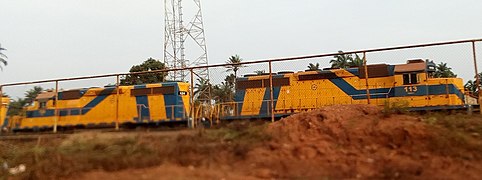
Guinea has 1,086 km of railways. This includes 279 km at 1,435 mm gauge and 807 km at 1,000 mm gauge. The latter includes 662 km in common carrier service from Kankan to Conakry.
Fatoumata Baldé is a Guinean association football player who plays for her country's national women's team and currently plays for US Orléans in the Division 2 Feminine.

Compagnie des bauxites de Guinée (CBG) is a Guinean mining company. Since 1963 it has extracted bauxite from the notable mine in Sangarédi, in Boké Region in Guinea. It is 49% owned by the Guinean State, with the remainder owned by the Boké Investment Company, a 100%-owned subsidiary of Halco Mining, a consortium opened in 1962 by Harvey Aluminum Company to run mining operations in Guinea. Halco's stock is owned by Alcoa (45%), Rio Tinto Alcan (45%) and Dadco Investments (10%).