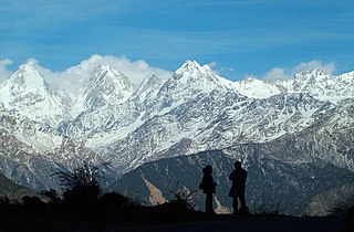
Kumaon is a revenue and administrative division in the Indian State of Uttarakhand. It spans over the eastern half of the state and is bounded on the north by Tibet, on the east by Nepal, on the south by the state of Uttar Pradesh, and on the west by Garhwal. Kumaon comprises six districts of the state: Almora, Bageshwar, Champawat, Nainital, Pithoragarh and Udham Singh Nagar.

Almora is a district in the Kumaon Division of Uttarakhand state, India. The headquarters is at Almora. It is 1,638 meters above sea level. The neighbouring regions are Pithoragarh district to the east, Chamoli district to the west, Bageshwar district to the north and Nainital district to the south.

Gangolihat is a town in the Pithoragarh district of Uttarakhand, India. It is the headquarters of an eponymous tehsil ~ one of the 12 revenue subdivisions of the Pithorarh district.

The Chand kings were a Hindu ruling dynasty of Kumaon. The Chand kingdom was established by displacing the Katyuri kings, The Chand kings ruled over the Kumaon Kingdom and parts of the Farwestern Nepal called Doti in present day Sudurpashchim Province.

Pithoragarh is a Himalayan town with a Municipal Board in Pithoragarh district in the Indian state of Uttarakhand. It is the largest hill town in Kumaon Division.

Bageshwar is a district of Uttarakhand state in northern India. The town of Bageshwar is the district headquarters. Prior to its establishment as a district in 1997 it was part of Almora district.
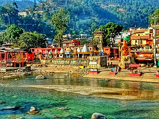
Bageshwar is a town and a municipal board in Bageshwar district in the state of Uttarakhand, India. It is located at a distance of 470 km from the National Capital New Delhi and 332 km from the State Capital Dehradun. Bageshwar is known for its scenic environment, glaciers, rivers and temples. It is also the administrative headquarters of Bageshwar district.

Almora is a municipal board and a cantonment town in the state of Uttarakhand, India. It is the administrative headquarters of Almora district. Almora is located on a ridge at the southern edge of the Kumaon Hills of the Himalaya range. The Koshi (Kaushiki) and Suyal (Salmale) rivers flow along the city and snow-capped Himalayas can be seen in the background.

Lohaghat is a town and a nagar palika in Champawat district in the Indian state of Uttarakhand.
Chandola is a Brahmin surname of Garhwali and Kumaoni origin mostly used in the Indian state of Uttarakhand.

Chaukori is a hill station in the Pithoragarh district set among the lofty peaks of the western Himalayan Range in the Kumaon Division of Uttarakhand, India. To its north is Tibet and to its south is Terai. The Mahakali River, running along its eastern boundary, forms the Indo-Nepal international border. This place has become a prominent tourist place and from here a wide and picturesque view of Himalayan range can be viewed. The golden yellow colour of sun rays falling on the Himalayan range in the morning time is really worth seeing. There are cottages available here where one can stay and enjoy the serene surroundings. Tourists coming to this place generally also visit the nearby tourist places like Patal Bhuvaneshwar, Kausani, Bageshwar and Almora.

Baijnath is a small town on the banks of the Gomati river in the Bageshwar district in Kumaon division of Uttarakhand, India. The place is most noted for its ancient temples, which have been recognized as Monuments of National Importance by the Archaeological Survey of India in Uttarakhand. Baijnath has been selected as one of the four places to be connected by the 'Shiva Heritage Circuit' in Kumaon, under the Swadesh Darshan Scheme of the Government of India.
The Katyuri kings were a medieval Hindu ruling clan of Khasha origin that ruled over the regions in Uttarakhand in India and western Nepal from 700 to 1200 CE. The founder of this dynasty, King Vasu Dev was originally a Buddhist ruler, but later he started following Hindu practices sometimes attributed to a vigorous campaign of Hindu philosopher Adi Shankara.
Uttarakhand is a state in North India. Its name, which means "northern land" or "section" or "northern part" in Sanskrit, is mentioned in early Hindu texts as the combined region of Kedarkhand and Manaskhand.

Kumaon Kingdom was an independent Himalayan kingdom in Kumaon, a region located in the eastern part of the present-day Uttarakhand state of India. It was established around 7th century and remained an independent and sovereign kingdom until 1791.
Kapkot or Kapkote is a village in Bageshwar district, Uttarakhand, India. It houses the headquarters of Kapkot Tehsil, the largest administrative subdivision of Bageshwar district. It is known for being the last bus terminus on the route to Pindari Glacier. Kapkot is located almost 25 kilometres (16 mi) from its district headquarters at Bageshwar.

Bagnath Temple is an ancient shrine dedicated to Shiva, situated in the Bageshwar city at the confluence of Sarayu and Gomati rivers. Bagnath Temple is festooned with bells of all sizes and features impressive carvings. It is the most famous Temple in Bageshwar District. It is flooded with devotees on the occasion of Shivratri. The city of Bageshwar gets its name from this Temple.
Mankot is a Village situated in Bageshwar district in the State of Uttarakhand, India. It is located at a distance of 13.5 kilometres (8.4 mi) from Bageshwar on the National Highway 309A. Mankot is a medium-sized village with total 118 families residing.

Baijnath Temple Complex is a cluster of 18 Hindu temples which are situated in the town of Baijnath in Uttarakhand, India. The complex is located in Bageshwar district along the banks of Gomati river at an elevation of 1,125 m (3,691 ft) above the mean sea level. These temples are renowned for possibly being one of the very few temples in the world where Parvati is depicted with her husband Shiva. Pilgrims arrive here on occasion of Shivratri and Makar Sankranti.
The Coolie-Begar or Coolie- Utar movement was a non-violent movement by the general public of Kumaun in the Bageshwar town of United Provinces in 1921. This movement was led by Hargovind Pant and Badri Datt Pandey, who were awarded the titles of 'Jannayak' and 'Kumaon Kesari' respectively after the success of this movement. The aim of this movement was to put pressure on the British to end the practice of Coolie-Begar. Mahatma Gandhi, while praising the movement, named it 'Bloodless Revolution'.


