Related Research Articles
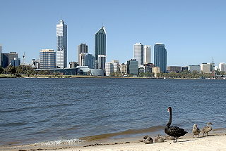
The Swan River is a river in the south west of Western Australia. The river runs through the metropolitan area of Perth, Western Australia's capital and largest city.

Heathcote National Park is a protected national park that is located in the southern region of Sydney, New South Wales in eastern Australia, and is situated on Dharawal country. The 2,679-hectare (6,620-acre) national park is situated approximately 35 kilometres (22 mi) southwest of the Sydney central business district, west of the South Coast railway line, the Princes Highway and Motorway, and the suburbs of Heathcote and Waterfall.

Warragamba Dam is a heritage-listed dam in the outer South Western Sydney suburb of Warragamba, Wollondilly Shire in New South Wales, Australia. It is a concrete gravity dam, which creates Lake Burragorang, the primary reservoir for water supply for the city of Sydney. The dam wall is located approximately 65 kilometres (40 mi) W of Sydney central business district, 4½ km SW of the town of Wallacia, and 1 km NW of the village of Warragamba.

Lake Burragorang is a man-made reservoir in the lower Blue Mountains of New South Wales, Australia, serving as a major water supply for greater metropolitan Sydney. The dam impounding the lake, the Warragamba Dam, is located approximately 60 kilometres (37 mi) southwest of the Sydney central business district.

The River Torrens, is the most significant river of the Adelaide Plains. It was one of the main reasons for the siting of the city of Adelaide, capital of South Australia. It flows 85 kilometres (53 mi) from its source in the Adelaide Hills near Mount Pleasant, across the Adelaide Plains, past the city centre and empties into Gulf St Vincent between Henley Beach South and West Beach. The upper stretches of the river and the reservoirs in its watershed supply a significant part of the city's water supply.

Blackburn Lake Sanctuary is an example of regenerated and remnant bushland in suburban Melbourne, Australia. It is located in the suburb of Blackburn. It is the most significant of the many parks in the City of Whitehorse, featuring areas of regenerated bushland and various walking tracks.

The Grose Valley is a rugged valley in the Blue Mountains, New South Wales, Australia. It has been formed by the Grose River, the headwaters of which are in the Mount Victoria area. The valley is located between the Great Western Highway and Bells Line of Road, the two major routes across the Blue Mountains. The majority of the valley falls within the Blue Mountains National Park.

The Helena River is a tributary of the Swan River in Western Australia. The river rises in country east of Mount Dale and flows north-west to Mundaring Weir, where it is dammed. It then flows west until it reaches the Darling Scarp.

The Queanbeyan River, a perennial stream that is part of the Molonglo catchment within the Murray–Darling basin, is located in the Monaro and Capital Country regions of New South Wales and the Australian Capital Territory, in Australia. The river is 104 kilometres (65 mi) in length with a catchment area of 96,000 hectares. The Queanbeyan River and the Cotter River meet the potable water supply needs of the Canberra and Queanbeyan region and whose water quality is specifically protected under Federal legislation.

Copeton Dam is a major clay core and rock fill embankment dam with nine radial gates and a gated concrete chute spillway across the Gwydir River upstream of Bingara in the New England region of New South Wales, Australia. The dam's purpose includes environmental flows, hydro-electric power generation, irrigation, and water supply. The impounded reservoir is called Lake Copeton.
The Shoalhaven Scheme is a dual-purpose water supply and Pumped-storage Hydroelectricity scheme located on the South Coast region of New South Wales, Australia.

Tempe Terra is a heavily cratered highland region in the northern hemisphere of the planet Mars. Located at the northeastern edge of the Tharsis volcanic province, Tempe Terra is notable for its high degree of crustal fracturing and deformation. The region also contains many small shield volcanoes, lava flows, and other volcanic structures.
The Lerderderg Gorge is in Victoria, Australia. The Lerderderg River which emerges from the Great Dividing Range has cut a deep gorge as it winds toward the southern plains.

The Canning Dam and reservoir provide a major fresh water resource for the city of Perth, Western Australia. The dam is situated on the Darling Scarp and is an impoundment of the Canning River. It is noted for its innovative structural and hydraulic design that was considered to be at the forefront of concrete gravity dam design at the time of construction. The Canning Dam was Perth's primary water supply up until the 1960s when other sources of fresh water were tapped. Currently the dam supplies approximately 20 percent of Perth's fresh water. Inflow into the Canning Reservoir is estimated to be 22 gigalitres and has a storage capacity of 90.352 gigalitres.

Catalina Park is a disused motor racing venue, located at Katoomba, in the Blue Mountains, New South Wales, Australia, and is recognised as an Aboriginal Place due to the long association of the local Gundungarra and Darug clans to the area.

A drop structure, also known as a grade control, sill, or weir, is a manmade structure, typically small and built on minor streams, or as part of a dam's spillway, to pass water to a lower elevation while controlling the energy and velocity of the water as it passes over. Unlike most dams, drop structures are usually not built for water impoundment, diversion or raising the water level. Mostly built on watercourses with steep gradients, they serve other purposes such as water oxygenation and erosion prevention.

The Canning Contour Channel is a 16 kilometres (9.9 mi) series of man-made concrete channels and steel and cast-iron pipelines in the Darling Scarp in Western Australia constructed between July 1935 and December 1936. The project was a Depression era public works scheme to carry potable water from just below Canning Dam through the hills around and above Roleystone and Kelmscott to a screening, fluoridation and pumping station near Gosnells by following the natural contours of the Canning Valley—hence it was entirely gravity-fed. Where a tributary valley needed to be crossed, suspended or siphoning pipelines were used. From Gosnells, the water entered the city's pipeline distribution system.

A check dams is a small, sometimes temporary, dam constructed across a swale, drainage ditch, or waterway to counteract erosion by reducing water flow velocity. Check dams themselves are not a type of new technology; rather, they are an ancient technique dating from the second century A.D. Check dams are typically, though not always, implemented in a system of several dams situated at regular intervals across the area of interest.
The Kangaroo River Nature Reserve, part of the Kangaroo Valley Group of Nature Reserves, is a protected nature reserve that is located on the floor of the Kangaroo Valley in the Southern Highlands and South Coast regions of New South Wales in eastern Australia. The reserve is situated approximately 150 kilometres (93 mi) south of Sydney, 50 kilometres (31 mi) southwest of Wollongong and 16 kilometres (9.9 mi) northwest of Nowra. The reserve has a protective covenant placed upon it with purpose to ensure the protection of the natural heritage of this area. National parks in the area include the Morton National Park and the Budderoo National Park. Other nature reserves in the area include the Barren Grounds Nature Reserve, and the Cambewarra Range, Barrengarry and Rodway nature reserves – the latter three part of the Kangaroo Valley Group of Nature Reserves.

The Blue Gum Forest is a forest located in Blue Mountains National Park within the Grose Valley of the Blue Mountains in New South Wales west of Sydney, southeastern Australia. It is one of the best-known bushwalking sites in Australia. The forest is located within the UNESCO World Heritage Site known as the Greater Blue Mountains Area. The forest survived through the efforts of early Australian conservationists.
References
- ↑ "Perth Bushwalkers Club - Perth Bushwalkers Club". Perthbushwalkers.asn.au.
- ↑ "Archived copy". Archived from the original on 25 March 2021. Retrieved 4 January 2022.
{{cite web}}: CS1 maint: archived copy as title (link)