
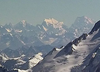
The Himalayas, or Himalaya, , is a mountain range in Asia separating the plains of the Indian subcontinent from the Tibetan Plateau. The range has many of Earth's highest peaks, including the highest, Mount Everest, at the border between Nepal and China. The Himalayas include over fifty mountains exceeding 7,200 m (23,600 ft) in elevation, including ten of the fourteen 8,000-metre peaks. By contrast, the highest peak outside Asia is 6,961 m (22,838 ft) tall.

The Karakoram is a mountain range spanning the borders of China, India, and Pakistan, with the northwest extremity of the range extending to Afghanistan and Tajikistan; its highest 15 mountains are all based in Pakistan. It begins in the Wakhan Corridor (Afghanistan) in the west and encompasses the majority of Gilgit-Baltistan (Pakistan) and extends into Ladakh (India) and the disputed Aksai Chin region controlled by China. It is the second highest mountain range in the world and part of the complex of ranges including the Pamir Mountains, the Hindu Kush and the Himalayan Mountains. The Karakoram has eighteen summits over 7,500 m (24,600 ft) height, with four of them exceeding 8,000 m (26,000 ft): K2, the second highest peak in the world at 8,611 m (28,251 ft), Gasherbrum I, Broad Peak and Gasherbrum II.

Ladakh is a region administered by India as a union territory, and constituting a part of the larger Kashmir region, which has been the subject of dispute between India, Pakistan, and China since 1947. It is bordered by the Tibet Autonomous Region to the east, the Indian state of Himachal Pradesh to the south, both the Indian union territory of Jammu and Kashmir and the Pakistan-administered Gilgit-Baltistan to the west, and the southwest corner of Xinjiang across the Karakoram Pass in the far north. It extends from the Siachen Glacier in the Karakoram range to the north to the main Great Himalayas to the south. The eastern end, consisting of the uninhabited Aksai Chin plains, is claimed by the Indian Government as part of Ladakh, and has been under Chinese control since 1962. Until 2019, Ladakh was a region of the state of Jammu and Kashmir. In August 2019, the Parliament of India passed an act by which Ladakh became a union territory on 31 October 2019.

Saser Kangri is a mountain in India. It is the highest peak in the Saser Muztagh, the easternmost subrange of the Karakoram range. Sasir Kangri is located within Ladakh, the northernmost union territory in India.
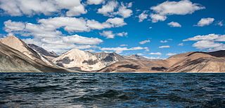
Pangong Tso or Pangong Lake is an endorheic lake spanning eastern Ladakh and West Tibet situated at an elevation of 4,225 m (13,862 ft). It is 134 km (83 mi) long and divided into five sublakes, called Pangong Tso, Tso Nyak, Rum Tso and Nyak Tso. Approximately 50% of the length of the overall lake lies within Tibet, 40% in Ladakh and the rest is disputed but controlled by China. The lake is 5 km (3.1 mi) wide at its broadest point. All together it covers 604 km2. During winter the lake freezes completely, despite being saline water. It has a land-locked basin separated from the Indus River basin by a small elevated ridge, but is believed to have been part of the latter in prehistoric times.
Saltoro Kangri is the highest peak of the Saltoro Mountains, also known as the Saltoro Range, which is a part of the Karakoram. It is the 31st highest mountain in the world, but it is in a very remote location deep in the Karakoram. It is located on the Actual Ground Position Line between Indian controlled territory in the Siachen region and Pakistani controlled territory west of the Saltoro Range.

Harish Kapadia is a distinguished Himalayan mountaineer, author and long-time editor of the Himalayan Journal from India. He has been awarded the Patron's Medal of the Royal Geographical Society, the Life Time Achievement Award for Adventure by the President of India and the King Albert Mountain Award presented by The King Albert I Memorial Foundation. He has written numerous books and articles on the Indian Himalayas. Harish was awarded the Piolets d'Or Asia Life Time Achievement Award in 2017 for his mountaineering and exploratory endeavours and he became the first and only Indian so far to ever receive this award.

The Saltoro Mountains are a subrange of the Karakoram Range. They are located in the heart of the Karakoram, on the southwest side of the Siachen Glacier, one of the two longest glaciers outside the polar regions. The name given to this range is shared with the Saltoro Valley which is located to the west of this range, downslope on the gilgit baltistan side of the Actual Ground Position Line.

The Rimo Muztagh is one of the most remote subranges of the Karakoram range. The southern part of Rimo Muztagh is in the Ladakh portion of far northwestern India, also claimed by Pakistan. The northern half, including the Rimo massif, is in the Siachen area. It is far from major towns, and close to the militarily sensitive Siachen Glacier, so it has seen little exploration or climbing activity compared to, for example, the nearby Baltoro Muztagh. The highest peak is Mamostong Kangri, 7,516 metres.
Rimo I is the main summit of the Rimo massif with an elevation of 7,385 metres (24,229 ft). It lies in the northern part of the remote Rimo Muztagh, a subrange of the Karakoram range. It is located about 20 km northeast of the snout of the Siachen Glacier and is the world's 71st highest mountain. Rimo means "striped mountain". The Rimo Glacier, originating here, drains to the Shyok river.
Surveyed as K35, Mamostong Kangri or Mamostang Kangri is the highest peak in the remote Rimo Muztagh, a subrange of the Karakoram range in Ladakh union territory of India near its border with China. It is located about 30 km east-southeast of the snout of the Siachen Glacier. It is the 48th highest independent peak in the world.
The Teram Kangri group is a mountain massif in the remote Siachen Muztagh, a subrange of the Karakoram range. The high point of the group, and of the Siachen Muztagh, is Teram Kangri I. The peak lies on the boundary between China and the disputed Siachen Glacier region near the line of control between India and Pakistan. The northeast side of the peak is in Chinese-controlled territory, the southwest side in the disputed Siachen area currently controlled by India. Teram Kangri I was first climbed on August 10, 1975 by a Japanese expedition led by H. Katayama, which obtained a permit from the Govt. of Pakistan and made the long approach via Bilafond La. They climbed the SW ridge of Teram Kangri II and then took the East ridge to the top. Teram Kangri II was climbed on August 12 and 13 by six Japanese climbers.
Ghent Kangri is a high peak near the north end of the Saltoro Mountains, a subrange of the Karakoram range. It is located west of the Siachen Glacier on the Actual Ground Position Line between India and Pakistan.

The geographical region of Ladakh union territory is the highest altitude plateau region in India, incorporating parts of the Himalayan and Karakoram mountain ranges and the upper Indus River valley. Historically populated by the Ladakhi people, continued immigration and preferential treatment to Kashmiris by the J&K government have led to demographic changes in the Ladakh region.
The Indian Himalayan Region (IHR) is the section of the Himalayas within India, spanning 11 Indian states and union territories namely Jammu and Kashmir, Ladakh, Himachal Pradesh, Uttarakhand, Sikkim, Arunachal Pradesh, Nagaland, Manipur, Mizoram, Tripura, Meghalaya, Assam and West Bengal. The region is responsible for providing water to a large part of the Indian subcontinent and contains various flora and fauna.
The Indira Col, also called Indira Col West lies next to Indira Col East, is a col on the Indira Ridge in the Siachen Muztagh in the Karakoram Range. It is within 3 km of Sia Kangri to the west, the summit of which is the tripoint where territories controlled by India, Pakistan, and China meet.
Sia Kangri is a mountain in the Baltoro Muztagh in the Karakoram. Its summit lies on the boarder of Pakistan and China. About a kilometer southeast of the Sia Kangri summit is the tri point where territories controlled by India, Pakistan and China meet. Territories on all sides are disputed. The land immediately to the southwest of the peak is claimed by both Pakistan and India and controlled by Pakistan. The land to the northeast is part of the Trans-Karakoram Tract, controlled by China under a 1963 border agreement with Pakistan but is claimed by India. The land to the southeast is claimed by Pakistan and India, but controlled by India, as a part of Ladakh. It is the 63rd highest mountain in the world, and the 25th highest in Pakistan. The peak is on the watershed between the Indus River basin and the Tarim Basin. Indira Col which is 3 km to the east is India's northernmost point.

Apsarasas Kangri is a mountain in the Siachen subrange of the Karakoram mountain range. With an elevation of 7,245 m (23,770 ft) it is the 96th highest mountain in the world. Apsarasas Kangri is located within the broader Kashmir region disputed between India, Pakistan and China. It is situated on the border between the areas controlled by China as part of the Xinjiang autonomous region, and the Siachen Glacier controlled by India as part of Ladakh.
