Kanturk

Last updated

Kanturk
Irish: Ceann Toirc
Town
Kanturk, County Cork - Kanturk Castle.jpg
Kanturk Castle
Ireland adm location map.svg
Red pog.svg
Kanturk
Location in Ireland
Coordinates: 52°10′30″N8°54′0″W / 52.17500°N 8.90000°W / 52.17500; -8.90000
CountryIreland
Province Munster
County County Cork
Population
 (2022) [1]
2,803
Time zone UTC+0 (WET)
  Summer (DST) UTC-1 (IST (WEST))

Kanturk (Irish : Ceann Toirc, meaning 'boar's head') [2] [3] is a town in the north west of County Cork, Ireland. It is situated at the confluence of the Allua (Allow) and Dallow (Dalua) rivers, [4] which stream further on as tributaries to the River Blackwater. It is about 50 kilometres (31 miles) from Cork and Limerick, and lies just north of the main N72 road, 15 km (9 miles) from Mallow and about 40 km (25 miles) from Killarney. Kanturk is within the Cork North-West Dáil constituency.

Contents

History

Located at a crossing point at the confluence of the River Allow and River Dalua, evidence of ancient settlement near Kanturk includes a number of ringfort, holy well and fulacht fiadh sites in the surrounding townlands of Coolacoosane, Curragh, Greenane and Gurteenard. [5] The town's English name, Kanturk, derives from the Irish Ceann Toirc or Ceann Tuirc, meaning head (or headland) of the boar. [2] [6]

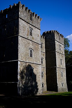
To the south of the town, in Paal East townland, is Kanturk Castle. Known locally as the Old Court, [7] this fortified house was built c.1601 for MacDonogh McCarthy as a defence against English settlers during the Plantation of Ireland. [8] [9] The building was a limestone rubble Tudor mansion four storeys high, 28 metres in length and 11 metres wide, with four towers of five storeys high and a height of 29 metres. The castle was never fully completed. [10] [4] Work stopped c.1618, reputedly because local English settlers were concerned that the structure was too large and fortified, and could be used as a base to attack them. [11] Accordingly, the Privy Council in England ordered that building works be stopped. After changing hands several times in the intervening centuries, Kanturk Castle is now owned by An Taisce (the National Trust for Ireland), [12] and is a designated National Monument. [10]

As of 2015, there were 32 buildings or structures listed on the Record of Protected Structures for County Cork. [13] These include a number of the town's bridges, which date to the late 18th and early 19th centuries. [14] [15] The larger religious and administrative buildings in Kanturk date to the early to mid-19th century, including the former market house (1810), [16] court house (1825), [17] Church of Ireland church (1858), [18] and Roman Catholic church (1867). [19]

Economy and amenities

The local creamery, North Cork Creameries, was founded in 1928 and produces casein powder and other milk products. [20] [21]

The "Unity Stone", in Kanturk Unity Park has an inscription and a notice indicating that the park was opened by then President Mary McAleese on 7 July 1998 Unity Stone, Kanturk Park, Co. Cork.jpg
The "Unity Stone", in Kanturk Unity Park has an inscription and a notice indicating that the park was opened by then President Mary McAleese on 7 July 1998

Kanturk's library offers lending facilities, newspapers, reference books, internet access and also organises cultural events. [22] [23]

Kanturk Town Park is a short distance from the town shopping centre. The "Unity Stone" monument is located near the park's entrance. The park has oak, beech, chestnut and ash trees, a children's playground, some cultural exhibits, and a walkway by the banks of the Dalua.[ citation needed ]

The town's schools include a number of national (primary) schools and two co-educational secondary schools. The secondary schools, Coláiste Treasa and Scoil Mhuire, have enrollments of over 500 and 270 students respectively. [24] [25]

Sport

Kanturk GAA club has a hurling team and a football team, both men's and women's from underage to Intermediate level. The local pitch is located in Kilroe, just outside the town. Kanturk RFC is a rugby union club which is also located just outside the town, at Knocknacolan. Founded in 1927, the club played in the All-Ireland League for five years and now plays in the Munster Junior League. An eighteen-hole golf course is located on Mill Road, where milling used to take place. The local association football soccer pitch has facilities to accommodate a number of teams. Kanturk also has a cycling club with its own outdoor 250m velodrome, one of only three on the island of Ireland. [26]

Kanturk has a trout fishing club which maintains the rivers that flow through the town. From Newmarket, the Dalua river flows into the Allow (Freemount River) in the centre of the town. A further 2 km (1 mile) south of the town the river Brogeen flows into the Allow. The Allow joins the River Blackwater; known for its salmon fishing, a further 3 km (2 mi) downstream at Leaders Bridge on the N72 Mallow to Killarney road. The Kanturk Trout Anglers Association has been represented on the international stage on several occasions, with past members participating at the World Fly Fishing Championships. [27] [28]

Transport

By rail, Kanturk is served by the nearby Banteer railway station, which is 6 km (4 mi) from Kanturk. The town's one-time railway station opened on 1 April 1889, closed for passenger traffic on 27 January 1947 and finally closed altogether on 4 February 1963. [35]

Bus routes serving Kanturk include weekday services to Mallow, one of which continues to Cork. On Saturdays, there is a single bus service to Cork via Mallow. Kanturk is not served by bus on Sundays.

Kanturk is 51 km (32 mi) from Kerry Airport and a little over 60 km (37 mi) from Cork Airport.

People

Thady Kelleher, International Champion Ploughman from Duhallow, displayed on the approach roadside to Kanturk Bronze ploughman, Kanturk, Co Cork, Ireland.JPG
Thady Kelleher, International Champion Ploughman from Duhallow, displayed on the approach roadside to Kanturk

People of note from the area include:

See also

Notes

  1. 1 2 "Census Mapping – Kanturk". Census 2022 . Central Statistics Office . Retrieved 7 December 2023.
  2. 1 2 "Ceann Toirc / Kanturk". logainm.ie. Irish Placenames Database. Retrieved 27 October 2020.
  3. "S.I. No. 395/2012 – Placenames (County Cork) Order 2012". Irish Statute Book. Office of the Attorney General. 2012. Retrieved 24 June 2022.
  4. 1 2 3 Lewis, Samuel (1837). "Kanturk". A Topographical Dictionary of Ireland . Dublin. Archived from the original on 30 October 2020. Retrieved 27 October 2020.
  5. Archaeological Inventory of County Cork. Volume 4: North Cork. Dublin: Government Stationery Office. 2000.
  6. Joyce, Patrick Weston (1869). The origin and history of Irish names of places, Volume 1. Dublin: McGlashan & Gill. p. 429. Kanturk, in Cork, is written by the Four Masters, Ceann-tuirc, the head or hill of the boar
  7. "The Old Court: The Story of Kanturk Castle". Archived from the original on 2 January 2017. Retrieved 28 November 2015.
  8. "Learning Zone – Primary School Students – Looking at Places – Kanturk Castle". askaboutireland.ie. Archived from the original on 16 April 2012. Retrieved 27 May 2013.
  9. "Historic Kanturk – An Overview". kanturk.ie. Archived from the original on 4 November 2017.
  10. 1 2 Heritage Castles of County Cork (PDF) (Report). Cork County Council. 2017. pp. 138–139. Archived (PDF) from the original on 30 October 2020. Retrieved 27 October 2020.
  11. "An Abandoned Project". theirishaesthete.com. 7 December 2015. Archived from the original on 1 November 2020. Retrieved 28 October 2020.
  12. "Our Work – Properties – Kanturk Castle, Co. Cork". antaisce.org. An Taisce – the National Trust for Ireland. 21 August 2019. Archived from the original on 31 October 2020. Retrieved 28 October 2020.
  13. "Section 3 (Settlements and other locations) Kanturk". Kanturk Electoral Area Local Area Plan, Second Edition, January 2015 (PDF) (Report). Cork County Council. 2015. p. 35. Retrieved 24 June 2022. Throughout the town as a whole, there are also 32 buildings or other structures entered in the Record of Protected Structures
  14. "Kanturk Bridge, William O'Brien Street, Main Street, Kanturk, County Cork". buildingsofireland.ie. National Inventory of Architectural Heritage. Archived from the original on 30 October 2020. Retrieved 27 October 2020.
  15. "Brogeen Bridge, Kanturk, County Cork". buildingsofireland.ie. National Inventory of Architectural Heritage. Archived from the original on 30 October 2020. Retrieved 27 October 2020.
  16. "Kanturk Credit Union, Strand Street, Kanturk, County Cork". buildingsofireland.ie. National Inventory of Architectural Heritage. Archived from the original on 30 October 2020. Retrieved 27 October 2020.
  17. "Court House, Church Street, Kanturk, County Cork". buildingsofireland.ie. National Inventory of Architectural Heritage. Archived from the original on 30 October 2020. Retrieved 27 October 2020.
  18. "Saint Peter's Church, Freemount Road, Egmont Place, Kanturk, County Cork". buildingsofireland.ie. National Inventory of Architectural Heritage. Archived from the original on 30 October 2020. Retrieved 27 October 2020.
  19. "Church of the Immaculate Conception, Church Street, Kanturk, County Cork". buildingsofireland.ie. National Inventory of Architectural Heritage. Archived from the original on 30 October 2020. Retrieved 27 October 2020.
  20. "It truly is dairy gold for North Cork Creameries". The Corkman. Independent News & Media. 2 November 2019. Archived from the original on 30 October 2020. Retrieved 27 October 2020.
  21. "North Cork Creameries reveal details of merger with co-op". The Corkman. Independent News & Media. 10 February 2018. Archived from the original on 30 October 2020. Retrieved 27 October 2020.
  22. "Kanturk Library Homepage". Archived from the original on 14 November 2016. Retrieved 13 February 2020.
  23. "Permanent library for Kanturk after three-year delay". irishexaminer.com. Irish Examiner. 11 September 2020. Archived from the original on 30 October 2020. Retrieved 27 October 2020.
  24. "Whole School Evaluation Report – Coláiste Treasa, Kanturk, County Cork" (PDF). education.ie. Department of Education. 8 May 2014. Archived (PDF) from the original on 30 October 2020. Retrieved 27 October 2020.
  25. "Whole School Evaluation Report – Scoil Mhuire, Kanturk, Co Cork" (PDF). education.ie. Department of Education. 7 December 2012. Archived (PDF) from the original on 13 October 2020. Retrieved 27 October 2020.
  26. "Our 'drome of dreams". The Corkman. Independent News & Media. 23 September 2012. Archived from the original on 30 October 2020. Retrieved 27 October 2020. There are two other tracks in Ireland, one which is in Dublin and which is 440 metres and the other is in Belfast
  27. "Michael hooks a bronze beauty at world c'ships in South Africa". The Corkman. Independent News & Media. 2 March 2019. Archived from the original on 30 October 2020. Retrieved 27 October 2020.
  28. "Kanturk man to join Irish team for World C'ships". The Corkman. Independent News & Media. 16 September 2000. Archived from the original on 30 October 2020. Retrieved 27 October 2020.
  29. "Census 2016 Sapmap Area – Settlements – Kanturk". CSO. 2016. Archived from the original on 19 August 2018. Retrieved 18 August 2018.
  30. "Census for post 1821 figures". Archived from the original on 9 March 2005. Retrieved 1 August 2009.
  31. "histpop.org". Archived from the original on 7 May 2016. Retrieved 13 February 2020.
  32. "nisranew.nisra.gov.uk". Archived from the original on 17 February 2012. Retrieved 28 January 2010.
  33. Lee, JJ (1981). "On the accuracy of the Pre-famine Irish censuses". In Goldstrom, J. M.; Clarkson, L. A. (eds.). Irish Population, Economy, and Society: Essays in Honour of the Late K. H. Connell. Oxford, England: Clarendon Press.
  34. Mokyr, Joel; O Grada, Cormac (November 1984). "New Developments in Irish Population History, 1700–1850". The Economic History Review. Volume. 37 (4): 473–488. doi:10.1111/j.1468-0289.1984.tb00344.x. hdl: 10197/1406 . Archived from the original on 4 December 2012.
  35. "Kanturk station" (PDF). Railscot – Irish Railways. Archived (PDF) from the original on 26 September 2007. Retrieved 16 October 2007.
  36. "The Doc: Remembering Pat O'Callaghan – Ireland's first Olympic hero". irishexaminer.com. Irish Examiner. 1 August 2018. Retrieved 5 October 2022.
  37. Jackie Daly kanturkarts.ie [ dead link ]
  38. Maume, Patrick (2009). "Johnson, Philip Francis". Dictionary of Irish Biography . doi:10.3318/dib.004295.v1 . Retrieved 5 October 2022.
  39. Maume, Patrick (2021). "Keating, Sean P." Dictionary of Irish Biography . doi:10.3318/dib.009790.v1 . Retrieved 5 October 2022.
  40. "Birthplace of Edel Quinn". kanturk.ie. Retrieved 5 October 2022.
  41. Maume, Patrick (2009). "Sheehan, Daniel Desmond ('D. D.')". Dictionary of Irish Biography . doi:10.3318/dib.008016.v1 . Retrieved 5 October 2022.
  42. Luddy, Maria (2009). "Skeffington, (Johanna) Hanna Sheehy-". Dictionary of Irish Biography . doi:10.3318/dib.008106.v1 . Retrieved 5 October 2022.
  43. Lunney, Linde; Cronin, Maurice (2009). "Ó Síocháin (Sheehan), Pádraig Augustine". Dictionary of Irish Biography . doi:10.3318/dib.006438.v1 . Retrieved 5 October 2022.

52°10′30″N8°54′0″W / 52.17500°N 8.90000°W / 52.17500; -8.90000

Related Research Articles

<span class="mw-page-title-main">Mallow, County Cork</span> Town in County Cork, Ireland

Mallow is a town in County Cork, Ireland, approximately thirty-five kilometres north of Cork. Mallow is in the barony of Fermoy.

<span class="mw-page-title-main">Kinvara</span> Village in south County Galway, Ireland

Kinvara or Kinvarra is a sea port village in the southwest of County Galway, Ireland. It is located in the civil parish of Kinvarradoorus in the north of the barony of Kiltartan. Kinvarra is also an electoral division.

<span class="mw-page-title-main">Lismore, County Waterford</span> Town in County Waterford, Ireland

Lismore is a historic town in County Waterford, in the province of Munster, Ireland. Originally associated with Saint Mochuda of Lismore, who founded Lismore Abbey in the 7th century, the town developed around the medieval Lismore Castle. As of the 21st century, Lismore supports a rural catchment area, and was designated as a "district service centre" in Waterford County Council's 2011–2017 development plan. As of 2022, the town had a population of 1,347 people.

<span class="mw-page-title-main">Millstreet</span> Town in County Cork, Ireland

Millstreet is a town in north County Cork, Ireland. As of the 2022 census, it had a population of 1,722.

The Dead Christ or The Redeemer in Death is a statue of Jesus Christ executed in white Carrara marble by the Irish sculptor John Hogan (1800–1858). The work was first sculpted by Hogan when he was based in Rome, alongside other artists such as sculptor Bertel Thorvaldsen (1770–1844). Thorvaldsen reputedly described the statue as Hogan's "masterpiece". In all, Hogan carved three versions of the statue in marble:

The Corkman is a weekly Irish regional newspaper based in County Cork. It is part of the Corkman Group and owned by Independent News and Media. The paper, based in Mallow, was primarily a North Cork newspaper. As of 2009, The Corkman was published in three editions, covering North Cork, Muskerry and Avondhu.

<span class="mw-page-title-main">Craughwell</span> Village and townland in County Galway, Ireland

Craughwell is a village and townland in County Galway, Ireland. As of the 2022 census, the village had a population of approximately 1,000 people.

<span class="mw-page-title-main">Kildorrery</span> Village in County Cork, Ireland

Kildorrery is a village in north County Cork, Ireland. It lies at the crossroads of the N73 road from Mallow to Mitchelstown and the R512 from Kilmallock to Fermoy. Kildorrery is part of the Cork East Dáil constituency.

<span class="mw-page-title-main">Dromcolliher</span> Town in County Limerick, Ireland

Dromcollogher, officially Dromcolliher, is a village located at the crossroads of the R522 and R515 regional roads in the west of County Limerick, Ireland. It is part of the parish of Dromcollogher-Broadford. It is also very close to the northern boundary of County Cork.

Rockchapel is a village in north County Cork in Ireland. It is located near the border of counties Cork, Kerry and Limerick. Rockchapel is within the Dáil constituency of Cork North-West.

<span class="mw-page-title-main">Newmarket, County Cork</span> Town in County Cork, Ireland

Newmarket, historically known as Aghatrasna, is a town in the barony of Duhallow, County Cork, Ireland. It is situated at the junction of the R576 and R578 regional roads. Newmarket is within the Cork North-West Dáil constituency

<span class="mw-page-title-main">Tallow, County Waterford</span> Town in County Waterford, Ireland

Tallow is a town, civil parish and townland in County Waterford, Ireland. Tallow is in the province of Munster near the border between County Cork and County Waterford and situated on a small hill just south of the River Bride.

<span class="mw-page-title-main">Mount Loftus</span>

Mount Loftus is a country estate in the civil parish of Powerstown in County Kilkenny, Ireland. It was originally home to the Loftus baronets, the baronetcy being extinct since the death of the third baronet in 1864. The original 18th century manor house was demolished in 1906. The current house on the estate, built in the early 20th century, was rebuilt from staff accommodations after a fire in the 1930s. This house, and several of its outbuildings, are included on Kilkenny County Council's Record of Protected Structures.

<span class="mw-page-title-main">Boherbue GAA</span> Gaelic games club in County Cork, Ireland

Boherbue GAA is a Gaelic Athletic Association club founded in 1888 and based in the village of Boherbue in the north-west of County Cork, Ireland. The club plays Intermediate A football in the Cork County Championship.

<span class="mw-page-title-main">Rockchapel GAA</span>

Rockchapel GAA is a Gaelic Athletic Association club based in the village of Rockchapel in the North West of County Cork, Ireland which forms part of the parish of Rockchapel and Meelin. The village is located close to border with County Kerry and County Limerick. The club plays Gaelic Football in the Duhallow division competitions. Ladies' Gaelic football is also played within the club. Rockchapel juvenile footballers play with St. Peter's which is an amalgamation of Meelin, Freemount and Rockchapel clubs at juvenile level. They last won the Duhallow Football Championship in 2012 and won the Cork County Junior Football Championship later that year.

<span class="mw-page-title-main">Castlemagner</span> Village in County Cork, Ireland

Castlemagner is a village and townland in the Duhallow area of north-west County Cork, Ireland. Castlemagner is within the Cork North-West.

<span class="mw-page-title-main">Ladysbridge</span> Village in County Cork, Ireland

Ladysbridge, known for census purposes as Knockglass, is a village in County Cork, Ireland. As of the 2016 census, the area had a population of 658 people.

The 1970 Cork Intermediate Hurling Championship was the 61st staging of the Cork Intermediate Hurling Championship since its establishment by the Cork County Board in 1909. The draw for the opening round fixtures took place on 25 January 1970. The championship began on 5 April and ended on 4 October 1970.

<span class="mw-page-title-main">Castlehyde</span> Townland and estate in County Cork, Ireland

Castlehyde is a townland and estate, slightly west of Fermoy in County Cork, Ireland. The estate's manor house, Castlehyde House, had been the ancestral home of Douglas Hyde's family and is one of several houses owned by Irish dancer, Michael Flatley.

<span class="mw-page-title-main">Araglin</span> Village in Counties Cork, Tipperary and Waterford in Ireland

Araglin, also known as Araglen, is a village on the border between counties Cork, Tipperary and Waterford in Ireland. It is approximately 17 km east of Fermoy, County Cork, 8 km south of Ballyporeen, County Tipperary and 18 km northwest of Lismore, County Waterford. The surrounding ecclesiastical parish, of Kilworth-Araglin, is in the Roman Catholic Diocese of Cloyne.