| Kaptai Lake | |
|---|---|
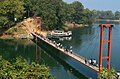
 Islets in the lake | |
 Kaptai Lake Location within Bangladesh | |
| Location | South-Eastern Bangladesh |
| Coordinates | 22°29′45″N92°13′45″E / 22.49583°N 92.22917°E |
| Type | reservoir |
| Primary inflows | Karnaphuli River |
| Primary outflows | Karnaphuli River |
| Catchment area | 11,122 km2 (4,294 sq mi) [ original research? ] |
| Basin countries | Bangladesh |
| Surface area | 688 km2 (266 sq mi) |
| Average depth | 100 ft (30 m) |
| Max. depth | 175 ft (53 m) |
Kaptai Lake is the largest man-made lake in Bangladesh. [1] It is located in the Kaptai Upazila under Rangamati District of Chittagong Division. The lake was created as a result of building the Kaptai Dam on the Karnaphuli River, as part of the Karnafuli Hydropower Station. Kaptai Lake's average depth is 100 feet (30 m) and maximum depth is 175 feet (53 m).