Karafuto Prefecture

Last updated

Karafuto Prefecture
樺太庁
Former subdivision of the Empire of Japan
1905–1945
Karafuto.svg
Green: Karafuto Prefecture within Japan in 1942
Light green: Other constituents of the Empire of Japan
Anthem
Karafuto tōka
Capital Ōtomari (1907–1908)
Toyohara (1908–1945)
Population 
 December 1941
406,557
History 
5 September 1905
 External territory status
1907
 Upgraded to "inner land"
1943
11–25 August 1945
 Dissolution
1 June 1945
Preceded by
Succeeded by
Flag of Russia.svg Sakhalin Department
Soviet Union Flag of the Soviet Union.svg
Sakhalin Oblast Flag of Sakhalin Oblast.svg
Today part of Russia

Karafuto Agency, from 1943 Karafuto Prefecture, [lower-alpha 1] commonly known as South Sakhalin, was a colony of the Empire of Japan on Sakhalin from 1907 to 1943 and later a prefecture until 1945.

Contents

Karafuto became a territory of the Empire of Japan in 1905 after the Russo-Japanese War, when the portion of Sakhalin south of 50°N was ceded from the Russian Empire in the Treaty of Portsmouth. Karafuto was established in 1907 as an external territory, until being upgraded to an "Inner Land" of the Japanese metropole in 1943. Ōtomari (Korsakov) was the capital of Karafuto from 1905 to 1908 and Toyohara (Yuzhno-Sakhalinsk) from 1908 to 1945.

In August 1945, the Japanese administration ceased to function following the invasion of South Sakhalin by the Soviet Union. Karafuto Prefecture was de facto replaced with Sakhalin Oblast, although it continued to exist de jure under Japanese law until it was formally abolished as a legal entity by Japan in June 1949.

Name

The Japanese name Karafuto purportedly comes from Ainu kamuy kar put ya mosir (カムィ・カㇻ・プッ・ヤ・モシㇼ), which means 'the island a god has created on the estuary (of Amur River)'.[ not verified in body ] It was formerly known as Kita Ezo, meaning Northern Ezo (Ezo was the former name for Hokkaido). When the Japanese administered the prefecture, Karafuto usually meant Southern Sakhalin only. For convenience, the northern part of the island was sometimes called Sagaren.

In Russian, the entire island was named Sakhalin or Saghalien. It is from Manchu sahaliyan ula angga hada, meaning "peak of the mouth of Amur River". The southern part was simply called Yuzhny Sakhalin ("South Sakhalin"). In Korean, the name is Sahallin or Hwataedo, with the latter name in use during Korea under Japanese rule.

History

Map of Sakhalin with parallels showing the division at the 50th parallel north with the Karafuto Prefecture highlighted in red Karafuto map.png
Map of Sakhalin with parallels showing the division at the 50th parallel north with the Karafuto Prefecture highlighted in red
The Karafuto Prefectural Office in Toyohara Karafuto Prefectural Office.JPG
The Karafuto Prefectural Office in Toyohara

Japanese settlement on Sakhalin dates to at least the Edo period. Ōtomari was established in 1679, and cartographers of the Matsumae domain mapped the island, and named it "Kita-Ezo". Japanese cartographer and explorer Mamiya Rinzō established that Sakhalin was an island through his discovery of what is now named Mamiya Strait (Strait of Tartary) in 1809. Japan unilaterally proclaimed sovereignty over the whole island in 1845.

The 1855 Treaty of Shimoda acknowledged that both the Russian Empire and Japan had joint rights of occupation to Sakhalin, without setting a definite territorial demarcation. As the island became settled in the 1860s and 1870s, this ambiguity led to increasing friction between settlers. Attempts by the Tokugawa shogunate to purchase the entire island from the Russian Empire failed, and the new Meiji government was unable to negotiate a partition of the island into separate territories. In the Treaty of Saint Petersburg (1875), Japan agreed to give up its claims on Sakhalin in exchange for undisputed ownership of the Kuril Islands.

Japan invaded Sakhalin in the final stages of the Russo-Japanese War of 1904–1905, but per the 1905 Treaty of Portsmouth was allowed to retain only the southern portion of the island below the 50° N parallel. Russia retained the northern portion, although the Japanese were awarded favorable commercial rights, including fishing and mineral extraction rights in the north. In 1907, Karafuto Prefecture was officially established, with the capital at Ōtomari. In 1908, the capital was relocated to Toyohara.

In 1920, Karafuto was officially designated an external territory of Japan, and its administration and development came under the aegis of the Ministry of Colonial Affairs. Following the Nikolaevsk Incident in 1920, Japan briefly seized the northern half of Sakhalin, and occupied it until the establishment of formal diplomatic relations with the Soviet Union in 1925; however, Japan continued to maintain petroleum and coal concessions in northern Sakhalin until 1944. In 1943, the status of Karafuto was upgraded to that of an "inner land", making it an integral part of the Empire of Japan.

As Japan was extending its influence over East Asia and the Pacific through the establishment of a Greater East Asia Co-Prosperity Sphere, the Imperial Japanese Army as part of its offensive contingency plans to invade the Soviet Union if it either became involved in the Pacific War or collapsed due to the ongoing German invasion, proposed the annexation of the remaining northern half of Sakhalin to Japan. [1]

Soviet invasion

In August 1945, after repudiating the Soviet–Japanese Neutrality Pact in April, and according to the signed agreements of Yalta, in which Stalin pledged that the Soviet Union would enter the Pacific War three months after the defeat of Germany, the Soviet Union invaded Karafuto. The Soviet attack started on 11 August 1945, three weeks before the surrender of Japan. The Soviet 56th Rifle Corps, part of the 16th Army, consisting of the 79th Rifle Division, the 2nd Rifle Brigade, the 5th Rifle Brigade and the 214 Armored Brigade, [2] attacked the Japanese 88th Infantry Division. Although the Soviet Red Army outnumbered the Japanese by three to one, they advanced only slowly due to strong Japanese resistance. It was not until the 113th Rifle Brigade and the 365th Independent Naval Infantry Rifle Battalion from Sovetskaya Gavan landed in Tōro, a seashore village in western Karafuto, on 16 August that the Soviets broke the Japanese defense line. Japanese resistance grew weaker after this landing. Actual fighting continued until 21 August. Between 22 and 23 August, most remaining Japanese units agreed to a ceasefire. The Soviets completed the conquest of Karafuto on 25 August 1945, by occupying the capital of Toyohara.

Post-war

A Japanese soldier at the border between the Karafuto Prefecture and Soviet Sakhalin Border Security of the 50th parallel of north.JPG
A Japanese soldier at the border between the Karafuto Prefecture and Soviet Sakhalin

There were over 400,000 people living in Karafuto when the Soviet offensive began in early August 1945. Most were of Japanese or Korean extraction, though there was also a small White Russian community as well as some Ainu indigenous tribes. By the time of the ceasefire, approximately 100,000 civilians had managed to escape to Hokkaidō. The military government established by the Soviet Army banned the local press, confiscated cars and radio sets and imposed a curfew. Local managers and bureaucrats were made to aid Russian authorities in the process of reconstruction, before being deported to labor camps, either on North Sakhalin or in Siberia. In schools, courses in Marxism–Leninism were introduced, and Japanese children were obliged to sing songs in praise of Stalin.

Step by step Karafuto lost its Japanese identity. Sakhalin Oblast was created in February 1946, and by March all towns, villages and streets were given Russian names. More and more colonists began to arrive from mainland Russia, with whom the Japanese were obliged to share the limited stock of housing. In October 1946 the Soviets began to repatriate all remaining Japanese. By 1950 most had been sent, willing or not, to Hokkaidō. They had to leave all of their possessions behind, including any currency, Russian or Japanese. Today some keep alive the memory of their former home in the meetings of the Karafuto Renmei, an association for former Karafuto residents.

In 1945, with the defeat of Japan in World War II, the Japanese administration in Karafuto ceased to function. The Japanese government formally abolished Karafuto Prefecture as a legal entity on 1 June 1949. In 1951, at the Treaty of San Francisco, Japan renounced its rights to Sakhalin, but did not formally acknowledge Soviet sovereignty over it. [3] Since that time, no final peace treaty has been signed between Japan and Russia, and the status of the neighboring Kuril Islands remains disputed.

Geography

Economy

This Japanese D51 steam locomotive stands outside the present day Yuzhno-Sakhalinsk Railway Station, Sakhalin Oblast, Russia. They were used by the Soviet Railways until 1979. Japanese SL D51-22.jpg
This Japanese D51 steam locomotive stands outside the present day Yuzhno-Sakhalinsk Railway Station, Sakhalin Oblast, Russia. They were used by the Soviet Railways until 1979.

The pre-war economy of Karafuto was based on fishing, forestry and agriculture, together with extraction of coal and petroleum. In terms of industry, the paper industry and the charcoal production industry was well developed. Pulp for rayon production in Honshu was predominately sourced from Karafuto. [4] The territory suffered from a labor shortage through most of its history, and tax incentives were provided to encourage immigration. [5] Indigenous Nivkh and Oroks worked in Japanese-run fisheries and a synthetic textile plant near the Russian border. For the construction of the Toyohara-Maoka line, bonded labor was put to use, including Chinese contract laborers. By the end of the 1920s, these laborers would be replaced with Koreans. With the start of the Second Sino-Japanese War in 1937, their population would increase substantially. [6]

An extensive railway network was constructed in Karafuto to support the extraction of natural resources. The Karafuto Railway Bureau (樺太鐵道局, Karafuto Tetsudōkyoku) maintained 682.6 kilometers of track in four main lines and an additional 58.2 kilometers of track.

Government

Karafuto was administered from the central government in Tokyo as the Karafuto Agency (樺太廳, Karafuto-chō) under the Colonization Bureau (拓務局, Takumukyoku) of the Home Ministry. The Colonization Bureau became the Ministry of Colonial Affairs (拓務省, Takumushō) in 1923 at which time Karafuto was officially designated an overseas territory of the Empire of Japan.

When the Ministry of Colonial Affairs was absorbed into the new Ministry of Greater East Asia in 1942, the administration of Karafuto was separated, and Karafuto became an integral part of the Japanese archipelago.

Directors of the Karafuto Agency

NameFromTo
Kiichirō Kumagai 28 July 190531 March 1907
Kusunose Yukihiko 1 April 190724 April 1908
Takejirō Tokonami 24 April 190812 June 1908
Sadatarō Hiraoka 12 June 19085 June 1914
Bunji Okada 5 June 19149 October 1916
Akira Masaya 13 October 191617 April 1919
Kinjirō Nagai 17 April 191911 June 1924
Akira Masaya (second term)11 June 19245 August 1926
Katsuzō Toyota 5 August 192627 July 1927
Kōji Kita27 July 19279 July 1929
Shinobu Agata 9 July 192917 December 1931
Masao Kishimoto 17 December 19315 July 1932
Takeshi Imamura 5 July 19327 May 1938
Toshikazu Munei 7 May 19389 April 1940
Masayoshi Ogawa 9 April 19401 July 1943
Toshio Ōtsu 1 July 194311 November 1947

Major cities

Karafuto Prefecture with 4 subprefectures, namely Toyohara, Maoka, Esutoru and Shikuka. Toyohara City was also a part of Toyohara Subprefecture. Subprefectures of Karafuto Prefecture.png
Karafuto Prefecture with 4 subprefectures, namely Toyohara, Maoka, Esutoru and Shikuka. Toyohara City was also a part of Toyohara Subprefecture.

As of 1945, Karafuto was divided into four subprefectures, which in turn were subdivided into 11 districts, in turn divided into 41 municipalities (one city, 13 towns, and 27 villages).

Karafuto's largest city was Toyohara, while other major cities included Esutoru in the north central and Maoka in the south central region.

The list below are the towns and the city of the prefecture. These in italics are the corresponding current Russian names.

Esutoru Subprefecture ( 惠須取支廳 )

Maoka Subprefecture ( 眞岡支廳 [7] )

Shikuka Subprefecture ( 敷香支廳 )

Toyohara Subprefecture ( 豐原支廳 [7] )

See also

Notes

  1. Japanese: 樺太庁, Karafuto-chō later 樺太県, Karafuto-ken; Russian: Префектура Карафуто, romanized: Prefektura Karafuto

Related Research Articles

<span class="mw-page-title-main">Sakhalin</span> Island in the Sea of Okhotsk

Sakhalin is an elongated island in Northeast Asia, located just 6.5 km (4.0 mi) off the southeastern coast of Khabarovsk Krai in Russia, and 40 kilometres (25 mi) north of Japan's Hokkaido. A marginal island of the West Pacific, Sakhalin divides the Sea of Okhotsk to its east from the Sea of Japan to its southwest. It is administered as part of Sakhalin Oblast and is the largest island of Russia, with an area of 72,492 square kilometres (27,989 sq mi). The island has a population of roughly 500,000, the majority of whom are Russians. The indigenous peoples of the island are the Ainu, Oroks, and Nivkhs, who are now present in very small numbers.

<span class="mw-page-title-main">Kuril Islands</span> Island chain located in Northeast Asia

The Kuril Islands or Kurile Islands are a volcanic archipelago administered as part of Sakhalin Oblast in the Russian Far East. The islands stretch approximately 1,300 km (810 mi) northeast from Hokkaido in Japan to Kamchatka Peninsula in Russia, separating the Sea of Okhotsk from the north Pacific Ocean. There are 56 islands and many minor islets. The Kuril Islands consist of the Greater Kuril Chain and, at the southwest end, the parallel Lesser Kuril Chain. They cover an area of around 10,503.2 square kilometres (4,055.3 sq mi), with a population of roughly 20,000.

<span class="mw-page-title-main">Treaty of Saint Petersburg (1875)</span> Territorial settlement between Japan and Russia

The Treaty of Saint Petersburg between the Empire of Japan and the Russian Empire was signed on 7 May 1875, and its ratifications exchanged at Tokyo on 22 August 1875. The treaty itself went into effect in 1877.

<span class="mw-page-title-main">Sakhalin Oblast</span> First-level administrative division of Russia

Sakhalin Oblast is a federal subject of Russia comprising the island of Sakhalin and the Kuril Islands in the Russian Far East. The oblast has an area of 87,100 square kilometers (33,600 sq mi). Its administrative center and largest city is Yuzhno-Sakhalinsk. As of the 2021 Census, the oblast has a population of roughly 500,000.

Subprefecture of Japan are a Japanese form of self-government which focuses on local issues below the prefectural level. It acts as part of the greater administration of the state and as part of a self-government system.

<span class="mw-page-title-main">Invasion of the Kuril Islands</span> 1945 Soviet invasion of the Japanese-owned Kuril Islands

The Invasion of the Kuril Islands was the World War II Soviet military operation to capture the Kuril Islands from Japan in 1945. The invasion, part of the Soviet–Japanese War, was decided on when plans to land on Hokkaido were abandoned. The successful military operations of the Red Army at Mutanchiang and during the invasion of South Sakhalin created the necessary prerequisites for invasion of the Kuril Islands.

<span class="mw-page-title-main">Shikotan</span> Disputed island in the Kurils

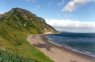
Shikotan, also known as Shpanberg or Spanberg, is an island in the Kurils administered by the Russian Federation as part of Yuzhno-Kurilsky District of Sakhalin Oblast. It is claimed by Japan as the titular Shikotan District, organized as part of Nemuro Subprefecture of Hokkaido Prefecture. The island's primary economic activities are fisheries and fishing, with the principal marine products being cod, crab, and kelp.

<span class="mw-page-title-main">Korsakov (town)</span> Town in Sakhalin Oblast, Russia

Korsakov is a town and the administrative center of Korsakovsky District of Sakhalin Oblast, Russia. It is located 42 kilometers (26 mi) south from Yuzhno-Sakhalinsk, at the southern end of Sakhalin Island, on the coast of the Salmon Cove in the Aniva Bay. The town has a population of 33,526 as of the 2010 census.

The Karafuto Fortress was the defensive unit formed by the Karafuto fortification installations, and the Karafuto detachment of Japanese forces, the 88th Division, created to defend against the Soviet invasion of South Sakhalin.

Between 1905 and 1945, the Japanese Empire administered the southern half of Sakhalin, using the name Karafuto (樺太). The area was designated a chō (廳), the same term given to Hokkaidō at the time. It is commonly referred to as Karafuto Prefecture in English. The prefecture was divided into 4 subprefectures, which in turn were subdivided into 11 districts, in turn divided into 41 municipalities

<span class="mw-page-title-main">Yuri (island)</span> Island in Sakhalin Oblast, Russia

Yuri (Iurii) is an uninhabited island in the Habomai Islands sub-group of the Kuril Islands chain in the south of the Sea of Okhotsk, northwest Pacific Ocean. The island is uninhabited from 1945 after the Soviet invasion of the Kuril Islands and deportation of Japanese to Hokkaido. It is currently administered as part of Yuzhno-Kurilsky District, Sakhalin Oblast of the Russian Federation. Its name is derived from the Ainu language word for cormorant.

<span class="mw-page-title-main">Shumshu</span> Island in the Kurile island chain

Shumshu is the easternmost and second-northernmost island of the Kuril Islands chain, which divides the Sea of Okhotsk from the northwest Pacific Ocean. The name of the island is derived from the Ainu language, meaning "good island". It is separated from Paramushir by the very narrow Second Kuril Strait in the northeast 2.5 kilometres (1.6 mi), and its northern tip is 11 kilometres (6.8 mi), from Cape Lopatka at the southern tip of the Kamchatka Peninsula. The island has a seasonal population of around 100 inhabitants.

<span class="mw-page-title-main">Tyuleny Island (Sea of Okhotsk)</span> Island in Sakhalin Oblast, Russian Federation

Tyuleny Island is a small uninhabited island in the Sea of Okhotsk, to the east of Russia's Sakhalin Island, in Northeast Asia. It is also known by its Japanese name 海豹島 and has two widely used spelling alternatives: Tuleny and Tyuleniy.

Kiri no Hi (霧の火) is a Japanese television drama which originally aired on Nippon Television (NTV) on August 25, 2008. Directed by Nozomu Amamiya and with a screenplay by Yō Takeyama, it starred Etsuko Ichihara and Karina Nose. The production won a TV Drama Award at the 2008 Festival of the Arts of the Japanese Agency for Cultural Affairs.

<span class="mw-page-title-main">Sakhalin Railway</span> Railway line in Sakhalin Oblast, Russia

Sakhalin Railway is a division of the Far Eastern Railway that primarily serves Sakhalin Island. Due to its island location, the railway is the second isolated 1520mm gauge network in Russia, like the Norilsk railway. The only main connection to the mainland is the Vanino–Kholmsk train ferry. The management is located at Yuzhno-Sakhalinsk.

<span class="mw-page-title-main">Japanese evacuation of Karafuto and the Kuril Islands</span> Evacuation of Japanese residents in the aftermath of World War II

The evacuation of Karafuto (Sakhalin) and the Chishima (kuril) islands refers to the events that took place during the Pacific theater of World War II as the Japanese population left these areas, to August 1945 in the northwest of the main islands of Japan.

<span class="mw-page-title-main">Japan–Russia border</span> International border

The Japan–Russia border is the de facto maritime boundary that separates the territorial waters of the two countries. According to the Russia border agency, the border's length is 194.3 km (120.7 mi).

<span class="mw-page-title-main">Soviet invasion of South Sakhalin</span> 1945 Soviet invasion of the Japanese portion of Sakhalin Island

The Soviet invasion of South Sakhalin, also known as the Battle of Sakhalin, was the Soviet invasion of the Japanese portion of Sakhalin Island known as Karafuto Prefecture. The invasion was part of the Soviet–Japanese War, a minor campaign in the Asian Theatre during Second World War.

Karafuto Prefecture, commonly called South Sakhalin, was the Japanese administrative division corresponding to Japanese territory on southern Sakhalin island from 1905 to 1945.

<span class="mw-page-title-main">Sakhalin Regional Museum</span> Building in Sakhalin Oblast, Russia

The Sakhalin Regional Museum is a museum in Yuzhno-Sakhalinsk on the Russian island of Sakhalin. It is the largest museum in the Sakhalin Oblast. The Museum collects, researches, and displays materials relating to the natural history, archaeology, history, and ethnography of the region.

References

  1. Krebs, Gerhard (1997). "31. Japan and the German-Soviet War". In Wegner, Bernd (ed.). From peace to war: Germany, Soviet Russia, and the world, 1939–1941. Berghahn Books. p. 551. ISBN   1-57181-882-0.
  2. 16th Army, 2nd Far Eastern Front, Soviet Far East Command, 09.08,45 [ permanent dead link ]
  3. Sevela, Marie. "Sakhalin: The Japanese Under Soviet rule". History Today, Vol. 48, 1998.
  4. Suzuki, Shinichi (January 1935). "The Rayon Industry in Japan". Economic Geography. 11 (1): 107. doi:10.2307/140653.
  5. Steven Ivings: Recruitment and coercion in Japan’s far north: Evidence from colonial Karafuto’s forestry and construction industries, 1910–37, in: Labor History, Vol. 57 (2016), No. 2, pp. 215–234.
  6. Morris-Suzuki, Tessa (August 2001). "Northern Lights: The Making and Unmaking of Karafuto Identity". The Journal of Asian Studies. 60 (3): 645–671. doi:10.2307/2700105.
  7. 1 2 3 4 樺太地名改正 明治四十一年三月三十一日內務省告示第二十九號

Further reading