
The Saale, also known as the Saxon Saale and Thuringian Saale, is a river in Germany and a left-bank tributary of the Elbe. It is not to be confused with the smaller Franconian Saale, a right-bank tributary of the Main, or the Saale in Lower Saxony, a tributary of the Leine.
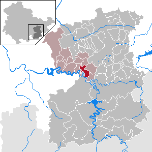
Saale-Holzland is a Kreis (district) in the east of Thuringia, Germany. Neighboring districts are the district Burgenlandkreis in Saxony-Anhalt, the district-free city Gera, the districts Greiz, Saale-Orla, Saalfeld-Rudolstadt, Weimarer Land and the district-free city Jena.
Saale-Orla is a Kreis (district) in the east of Thuringia, Germany. Neighboring districts are the districts Saale-Holzland, Greiz, the Vogtlandkreis in Saxony, the Bavarian districts Hof and Kronach, and the district Saalfeld-Rudolstadt.
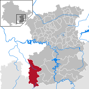
Saalfeld-Rudolstadt is a Kreis (district) in the south of Thuringia, Germany. Neighboring districts are the districts Weimarer Land, Saale-Holzland, Saale-Orla, the district Kronach in Bavaria, and the districts Sonneberg, Hildburghausen and Ilm-Kreis.
Weimarer Land is a Landkreis (district) in the east of Thuringia, Germany. Neighboring districts are the district Burgenlandkreis in Saxony-Anhalt, the district Saale-Holzland and the district-free city Jena, the district Saalfeld-Rudolstadt, Ilm-Kreis, and the district-free city Erfurt. The district-free city Weimar is completely enclosed by the district.
Saalfeld is a town in Germany, capital of the Saalfeld-Rudolstadt district of Thuringia. It is best known internationally as the ancestral seat of the Saxe-Coburg and Gotha branch of the Saxon House of Wettin.
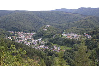
Schwarzburg is a municipality in the valley of the Schwarza in the district Saalfeld-Rudolstadt in Thuringia, Germany.

Rudolstadt is a town in the German federal state Thuringia, within the Thuringian Forest, to the southwest, and to Jena and Weimar to the north.

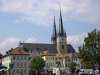
Bad Lobenstein is a spa town in the Saale-Orla-Kreis district, in Thuringia, Germany with a population of about 6,000 inhabitants. Until 2005, the town was named Lobenstein.

Gräfenthal is a town in the district of Saalfeld-Rudolstadt in Thuringia, Germany.

Hirschberg is a town in the Saale-Orla-Kreis district, in Thuringia, Germany. It is situated on the river Saale, 20 km south of Schleiz, 12 km northwest of Hof (Bavaria), and 25 km southwest of Plauen (Saxony).

Orlamünde is a small town in the Saale-Holzland district, in Thuringia, Germany. It is part of the Verwaltungsgemeinschaft Südliches Saaletal.

Ranis is a town in the Saale-Orla-Kreis district, in Thuringia, Germany. It is situated 15 km east of Saalfeld, and 30 km south of Jena.
Wurzbach is a town in the Saale-Orla-Kreis district, in southern Thuringia, Germany. It is situated 33 kilometres (21 mi) southeast of Saalfeld, and 45 kilometres (28 mi) northwest of Hof.
Ziegenrück is a town in the Saale-Orla-Kreis district, in southern Thuringia, Germany. It is situated on the river Saale, 22 km east of Saalfeld, and 35 km south of Jena.
Weißbach is a municipality in the district Saale-Holzland, in Thuringia, Germany. The name of the location was vouched first about 1400, according to other sources in 1072. Meat production is dominating in local business.
Crossen an der Elster is a village and municipality in the district Saale-Holzland, in Thuringia, Germany. The White_Elster is the name of the small river which flows through the municipality, so 'Crossen on the Elster' would be the English equivalent.
Hohenwarte is a municipality in the district Saalfeld-Rudolstadt, in Thuringia, Germany.
Uhlstädt-Kirchhasel is a municipality in the district Saalfeld-Rudolstadt, in Thuringia, Germany. On 1 December 2007, the former municipalities Großkochberg and Heilingen were incorporated by Uhlstädt-Kirchhasel. The valley of the river Saale is the centre of Uhlstädt-Kirchhasel. Both Uhlstädt and Kirchhasel are villages inside this valley, which divides the municipality into a northern and a southern part. The nearest bigger towns are Rudolstadt, Saalfeld and Jena.
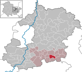
Saalfeld-Rudolstadt II is an electoral constituency represented in the Landtag of Thuringia. It elects one member via first-past-the-post voting. Under the current constituency numbering system, it is designated as constituency 29 and It covers the eastern part of Saalfeld-Rudolstadt.


