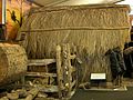
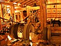
Kauri Museum

Last updated

Kauri Museum at Matakohe
NZ-Northland plain map2.png
Disc Plain red.svg
Kauri Museum at Matakohe
Coordinates: 36°7′46″S174°11′6″E / 36.12944°S 174.18500°E / -36.12944; 174.18500
1929 Caterpillar Sixty on display in the Kauri Museum. This 60 horsepower crawler tractor, one of five imported into New Zealand in 1930 for hauling logs, replaced eight bullock teams (112 animals). 1929 Caterpillar.jpg
1929 Caterpillar Sixty on display in the Kauri Museum. This 60 horsepower crawler tractor, one of five imported into New Zealand in 1930 for hauling logs, replaced eight bullock teams (112 animals).

The Kauri Museum is in the west coast village of Matakohe, Northland, New Zealand. The museum, to the south of the Waipoua Forest, contains many exhibits that tell the story of the pioneering days when early European settlers in the area extracted kauri timber and kauri gum. [1]

The museum has over 4000 sq metres of undercover exhibits, including the largest collection of kauri gum in the world, and the largest collection of kauri furniture. It has a model of a 1900s kauri house with furniture and models in the dress of the early years, and an extensive collection of photographs and pioneering memorabilia. [2] On the wall, there are full-scale circumference outlines of the huge trees, including one of 812 metres, larger even than Tāne Mahuta. The museum includes a working mock-up of a steam sawmill. [3]

It tells its story from the colonial viewpoint, and presents its representation of the kauri gum industry as part of the process of creating the New Zealand identity. It has little to say about negative aspects, such as the impact on the Māori people. [4]

The Kauri Museum has however helped raise awareness of the need to conserve the remaining forest through a display of photographs by the conservationist Stephen King, presented in partnership with the Waipoua Forest Trust. [5]

Related Research Articles

<span class="mw-page-title-main">Great Barrier Island</span> Island in New Zealand

Great Barrier Island lies in the outer Hauraki Gulf, New Zealand, 100 kilometres (62 mi) north-east of central Auckland. With an area of 285 square kilometres (110 sq mi) it is the sixth-largest island of New Zealand and fourth-largest in the main chain. Its highest point, Mount Hobson, is 627 metres (2,057 ft) above sea level. The local authority is the Auckland Council.

<span class="mw-page-title-main">National parks of New Zealand</span> Wikimedia list

The national parks of New Zealand are protected natural areas administered by the Department of Conservation (DOC). The first national parks established in the country were all focused on mountain scenery. Since the 1980s the focus has been on developing a more diverse representation of New Zealand landscapes. The parks are all culturally significant and many also contain historic features. Tongariro National Park is one of the World Heritage Sites that are of both cultural and natural significance, while four of the South Island national parks form Te Wahipounamu, another World Heritage Site. There are currently 13 national parks; a 14th, Te Urewera National Park, was disestablished in 2014.

<i>Agathis australis</i> Species of conifer in the family Araucariaceae

Agathis australis, or kauri, is a coniferous tree in the family Araucariaceae, found north of 38°S in the northern regions of New Zealand's North Island.

<i>Agathis</i> Genus of conifers in the kauri family Araucariaceae

Agathis, commonly known as kauri or dammara, is a genus of evergreen coniferous trees, native to Australasia and Southeast Asia. It is one of three extant genera in the family Araucariaceae, alongside Wollemia and Araucaria. Its leaves are much broader than most conifers. Kauri gum is commercially harvested from New Zealand kauri.

<span class="mw-page-title-main">Northland Region</span> Region of New Zealand

The Northland Region is the northernmost of New Zealand's 16 local government regions. New Zealanders sometimes refer to it as the Winterless North because of its mild climate all throughout the year. The main population centre is the city of Whangārei, and the largest town is Kerikeri. At the 2018 New Zealand census, Northland recorded a population growth spurt of 18.1% since the previous 2013 census, placing it as the fastest growing region in New Zealand, ahead of other strong growth regions such as the Bay of Plenty Region and Waikato.

<span class="mw-page-title-main">Waipoua Forest</span> Forest on New Zealands North Island

Waipoua Forest is a forest, on the west coast of the Northland Region of New Zealand's North Island. It preserves some of the best examples of kauri forest remaining in New Zealand. It is notable for having two of the largest living kauri trees, Tāne Mahuta and Te Matua Ngahere.

<span class="mw-page-title-main">Dargaville</span> Town in Northland, New Zealand

Dargaville is a town located in the North Island of New Zealand. It is situated on the bank of the Northern Wairoa River in the Kaipara District of the Northland region. Dargaville is located 55 kilometres (34 mi) southwest of Whangārei, and 174 kilometres (108 mi) north of Auckland.

<span class="mw-page-title-main">1873 Vienna World's Fair</span> International exhibition of the 19th century

The 1873 Vienna World's Fair was the large world exposition that was held from 1 May to 31 October 1873 in the Austria-Hungarian capital Vienna. Its motto was "Culture and Education".

<span class="mw-page-title-main">Kaipara Harbour</span> Harbour estuary in New Zealand

Kaipara Harbour is a large enclosed harbour estuary complex on the north western side of the North Island of New Zealand. The northern part of the harbour is administered by the Kaipara District and the southern part is administered by the Auckland Council. The local Māori tribe is Ngāti Whātua.

<span class="mw-page-title-main">Te Matua Ngahere</span> Large individual kauri tree in New Zealand

Te Matua Ngahere is a giant kauri coniferous tree in the Waipoua Forest of Northland Region, New Zealand. The tree's Māori name means "Father of the Forest". Although not as massive or tall as its neighbour Tāne Mahuta, Te Matua Ngahere is stouter, with a girth just over 16 metres (52 ft). It is believed to be the second largest living kauri tree, and to have the biggest girth of any kauri in the country. According to The New Zealand Herald, it has the biggest girth of any tree in New Zealand.

<span class="mw-page-title-main">Kauri gum</span> Resin

Kauri gum is resin from kauri trees, which historically had several important industrial uses. It can also be used to make crafts such as jewellery. Kauri forests once covered much of the North Island of New Zealand, before climate change caused the forests to retreat, causing several areas to revert to sand dunes, scrubs, and swamps. Even afterwards, ancient kauri fields and the remaining forests continued to provide a source for the gum. Between 1820 and 1900, over 90% of Kauri forests were logged or burnt by Europeans.

<span class="mw-page-title-main">Houhora</span> Place in Northland Region, New Zealand

Houhora is a locality and harbour on the east side of the Aupouri Peninsula of Northland, New Zealand. It is 41 km (25 mi) north of Kaitaia. Waihopo, Te Raupo, Pukenui, Raio and Houhora Heads are associated localities on the southern shores of the harbour. State Highway 1 passes through all these localities except for Houhora Heads. Te Kao is 24 km north west, and Waiharara is 22 km south east.

<span class="mw-page-title-main">Ruawai</span> Place in Northland Region, New Zealand

Ruawai is a small town located 30 km south of Dargaville in Northland, New Zealand.

<span class="mw-page-title-main">Matakohe</span> Place in Northland Region, New Zealand

Matakohe is a settlement in Northland, New Zealand. The Matakohe River is a short river which runs from the north into the Arapaoa River, which is part of the Kaipara Harbour. State Highway 12 passes through Matakohe. Ruawai is 16 km to the west, and Paparoa is 6 km north east. The Hukatere Peninsula extends south into the Kaipara Harbour.

<span class="mw-page-title-main">Deforestation in New Zealand</span>

Deforestation in New Zealand has been a contentious environmental issue in the past, but native forests now have legal protection, and are not allowed to be tampered with by humans.

<span class="mw-page-title-main">Northland temperate kauri forests</span>

The Northland temperate kauri forests is an ecoregion in northern New Zealand, within the temperate broadleaf and mixed forests biome.

<span class="mw-page-title-main">William Roy McGregor</span> New Zealand zoologist and conservationist (1894–1977)

William Roy McGregor was a New Zealand zoologist and conservationist who was successful in halting forestry in the Waipoua forest and establishing the forest as a protected sanctuary.

<span class="mw-page-title-main">Matakohe Post Office</span>

The former Matakohe Post and Telegraph Office was opened in 1909 and remained in use until its closure in 1988. The building was purchased in 1989 by the Kauri Museum then moved from its original location and resited to its current one next to the main museum complex on Church Street, Matakohe. and renovated to hold a collection of postal and communication related objects and images. The building was listed as a Category 2 Historic Place List No: 3911 with Heritage New Zealand in September 1984.

<span class="mw-page-title-main">Āwhitu Peninsula</span> Place in Auckland, New Zealand

The Āwhitu Peninsula is a long peninsula in the North Island of New Zealand, extending north from the mouth of the Waikato River to the entrance to Manukau Harbour.

<span class="mw-page-title-main">Ōmāpere</span> Place in Northland Region, New Zealand

Ōmāpere is a settlement on the south shore of Hokianga Harbour in Northland, New Zealand. State Highway 12 runs through Ōmāpere. Opononi is on the shore to the north of Ōmāpere.

References

  1. "The Kauri Museum". The Kauri Museum. Retrieved 8 December 2010.
  2. "The Kauri Museum Matakohe". National Services Te Paerangi . Retrieved 8 December 2010.
  3. Darroch Donald (2003). "Matakohe and the Kauri Museum". New Zealand. Footprint Travel Guides. p. 199. ISBN   1-903471-74-5.
  4. Paula Hamilton, Linda Shopes (2008). Oral history and public memories. Temple University Press. p. 162. ISBN   978-1-59213-141-9.
  5. "Other displays at the Kauri Museum". The Kauri Museum. Retrieved 7 December 2010.

36°7′46″S174°11′6″E / 36.12944°S 174.18500°E / -36.12944; 174.18500